
North-eastern Australia prepares for Severe Tropical Cyclone “Ita” landfall
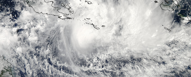
Image credit: NASA Goddard MODIS Rapid Response
What was once Low Pressure System that brought heavy rain and caused devastating floods to Solomon Islands strengthened into Tropical Storm Ita on April 5 on its approach to north-eastern Australia. Australian Government Bureau of Meteorology (BOM) has declared a Cyclone WATCH for coastal areas from Cape Grenville to Cairns.
At 12:00 UTC today (22:00 EST) Severe Tropical Cyclone Ita, Category 3, was estimated to be 670 kilometers east-northeast of Lockhart River and 630 kilometers northeast of Cooktown, moving west at 19 km/h.
The system is expected to continue moving in a general westwards direction towards the far north Queensland coast, while intensifying. GALES extend 220 kilometres out from the centre and may develop between Coen and Cooktown late Thursday and develop elsewhere between Cape Grenville and Cairns during Friday.
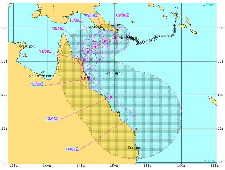
TC Ita forecast track by JTWC
According to Tropical Cyclone Warning Centre notification issued at 12:47 UTC (22:47 EST) today Severe Tropical Cyclone Ita poses a significant threat to communities along the far north Queensland coast and at this stage it is expected to approach the coast between Lockhart River and Cape Flattery and make landfall late Friday as a SEVERE CATEGORY 4 TROPICAL CYCLONE with VERY DESTRUCTIVE WINDS near the core and GALES extending some distance from the landfall location.
The sea may rise steadily up to a level which will be significantly above the normal tide between Cape Grenville and Cairns close to landfall on Friday, with damaging waves, strong currents and flooding of low-lying areas possible.
People living in low lying areas that may be affected by this flooding should take measures to protect their property as much as possible and be prepared to follow instructions regarding evacuation of the area if advised to do so by the authorities.
Very heavy rain, which may lead to flash flooding, is expected to develop about the Peninsula and northern parts of the North Tropical Coast and Tablelands districts on Thursday and persist into Friday.
People between Cape Grenville and Cairns should consider what action they will need to take if the cyclone threat increases and listen to the next advice at 5 am EST Thursday (19:00 UTC on Wednesday).

NASA's Aqua satellite captured this visible image of Tropical Cyclone Ita near eastern Papua New Guinea on April 8 at 3:30 UTC. Image credit: NASA Goddard MODIS Rapid Response
I'm a dedicated researcher, journalist, and editor at The Watchers. With over 20 years of experience in the media industry, I specialize in hard science news, focusing on extreme weather, seismic and volcanic activity, space weather, and astronomy, including near-Earth objects and planetary defense strategies. You can reach me at teo /at/ watchers.news.
Commenting rules and guidelines
We value the thoughts and opinions of our readers and welcome healthy discussions on our website. In order to maintain a respectful and positive community, we ask that all commenters follow these rules.