
Super Typhoon Bavi weakens slightly as Taiwan, Yaeyama Islands and eastern China brace for impacts
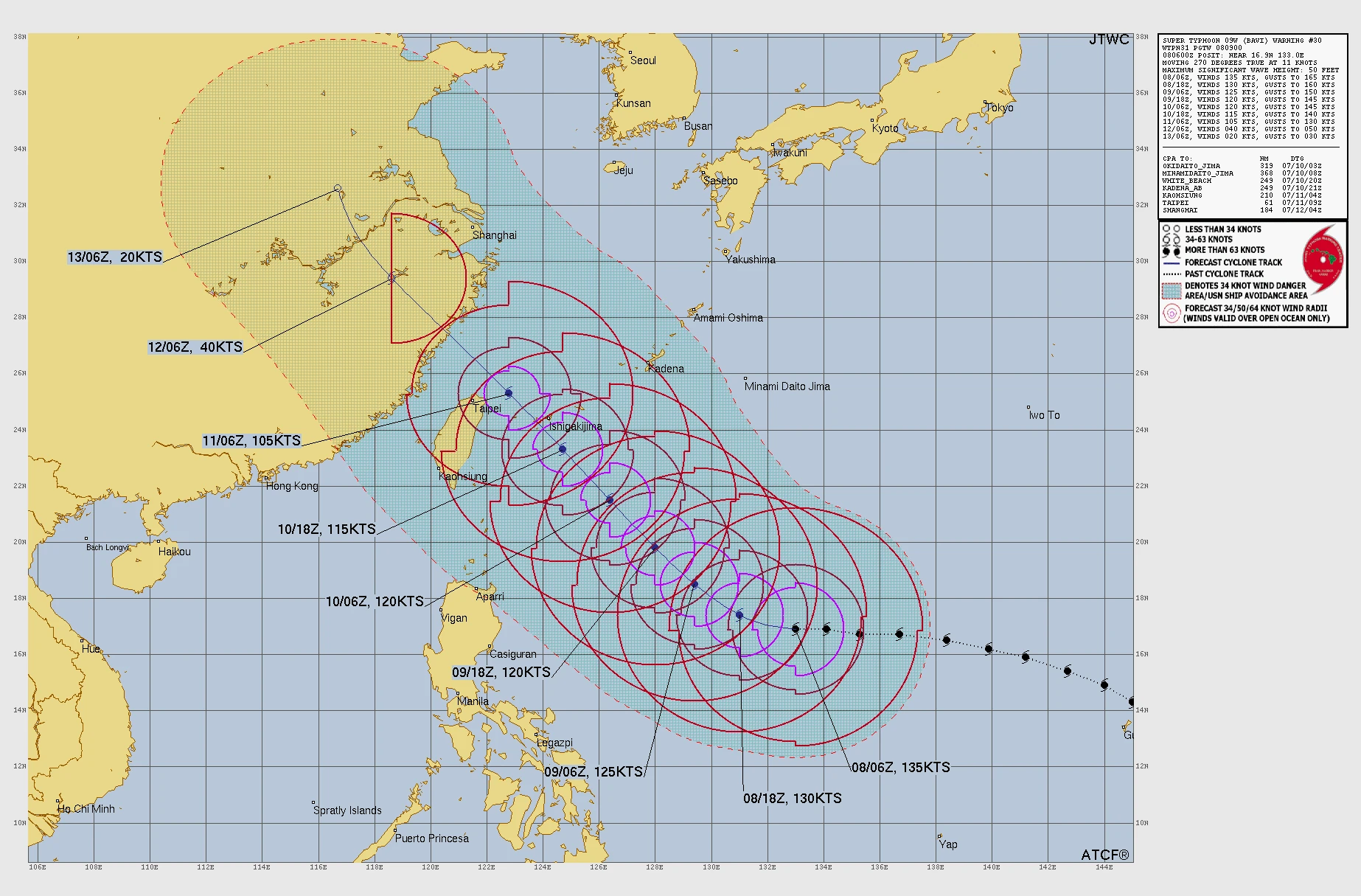
Super Typhoon Bavi maintained Category 4-equivalent intensity over the Philippine Sea on July 8, 2026, with maximum sustained winds of 250 km/h (155 mph) and higher gusts. The cyclone is forecast to weaken gradually before passing near Taiwan and Japan’s Yaeyama Islands around July 11 and making a possible landfall along the eastern coast of China around July 12.
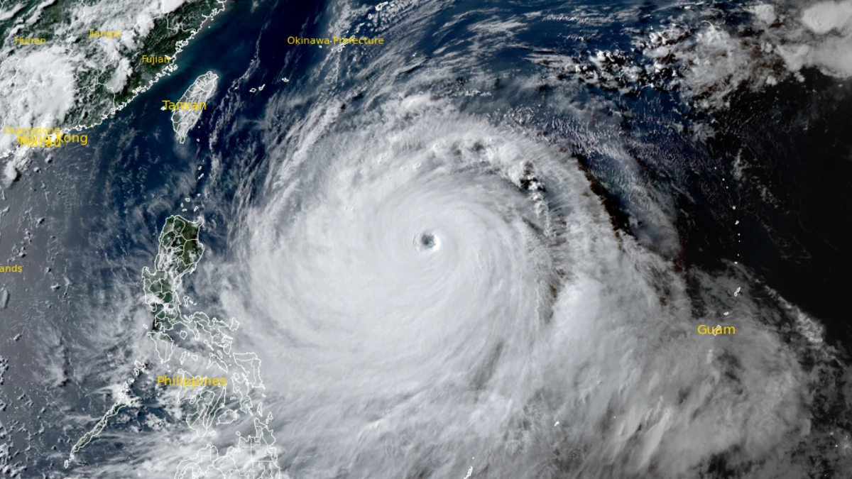
Satellite image of Super Typhoon Bavi at 08:30 UTC on July 8, 2026. Credit: JMA/Himawari-9, Zoom Earth, The Watchers
Super Typhoon Bavi was located about 1 030 km (640 miles) northwest of Yap and 1 375 km (855 miles) west-northwest of Guam, at 09:00 UTC on July 8.
1-minute maximum sustained winds reached 250 km/h (155 mph), as Bavi moved west at 21 km/h (13 mph). Typhoon-force winds extend up to 185 km (115 miles) from the center, while tropical-storm-force winds extend up to 483 km (300 miles).
It will maintain super typhoon intensity through the night of July 8 before beginning a gradual weakening trend on July 9 as it moves generally toward Taiwan.
The weakening is attributed to a combination of an ongoing eyewall replacement cycle and 46 to 56 km/h (29 to 35 mph) northeasterly vertical wind shear.
Bavi is expected to move west-northwest through July 8 into 9. Afterwards two subtropical ridges—one over Kyushu and another to the northeast of the storm—are forecast to merge, steering the system more northwestward through July 9 and the remainder of the week.
The cyclone is forecast to pass through the Yaeyama Islands around July 11, followed by landfall along the eastern coast of China around July 12. It will weaken as it moves over the Chinese mainland before dissipating west of Shanghai around July 13.
Microwave imagery revealed the development of a larger outer eyewall and a distinct moat feature, while satellite imagery showed warming cloud tops and a gradual loss of symmetry surrounding the eye.
Despite strong radial outflow aloft and warm sea-surface temperatures of 29 to 30°C (84 to 86°F), forecasters assessed that the environment had become only marginally favorable for maintaining peak intensity.
Earlier, Super Typhoon Bavi crossed the Northern Mariana Islands as a Category 5 cyclone on July 6, 2026, bringing maximum sustained winds of 290 km/h (180 mph) to Rota as the eyewall passed over the island. Local officials reported major damage while emergency warnings were issued across the Marianas.
CNMI Homeland Security and Emergency Management officials said Rota sustained the worst damage in the Commonwealth after the island took a direct hit from Bavi’s eye. First comprehensive damage assessments were underway, with officials reporting widespread damage to critical infrastructure, blocked roads, port concerns, power loss, and water-system damage.
Rota’s highest recovery priorities are restoring water access, clearing roads, and checking on residents’ overall condition. The Department of Public Works said crews were first clearing primary roads, roads to shelters and fire stations, and routes to seaports and the airport. A ruptured water transmission line from the Water Cave was also reported, with debris blocking access to parts of the damaged infrastructure.
The Commonwealth Ports Authority said Rota’s airport and seaport sustained the most significant transport damage in the CNMI. Preliminary work had cleared debris from the Rota airport runway, but the airport remained without commercial power, radio communications, weather reporting capability, and an operational windsock. Officials said restoring the airport was a priority for relief flights, supplies, and first responders.
The Rota West Harbor, which had already sustained damage during Super Typhoon Sinlaku, was undergoing further assessment after Bavi. Officials said additional damage was likely, but full inspections were still underway.
References:
1 Prognostic Reasoning for Super Typhoon 09W (Bavi), Warning No. 30 – JTWC – July 8, 2026
2 Super Typhoon Bavi (09W) Advisory No. 30. – NWS – July 8, 2026

I am an Assistant Editor and Severe Weather & Science Journalist at The Watchers, specializing in real-time severe weather coverage, geophysical event reporting, and research-driven scientific analysis. You can reach me at rishav(at)watchers(.)news.

Commenting rules and guidelines
We value the thoughts and opinions of our readers and welcome healthy discussions on our website. In order to maintain a respectful and positive community, we ask that all commenters follow these rules.