
Category 5 Super Typhoon Bavi batters Rota with 290 km/h (180 mph) winds, major damage reported
Super Typhoon Bavi crossed the Northern Mariana Islands as a Category 5 cyclone on Monday, July 6, 2026, bringing maximum sustained winds of 290 km/h (180 mph) to Rota as the eyewall passed over the island. Local officials reported major damage while emergency warnings remained in effect across the Marianas.
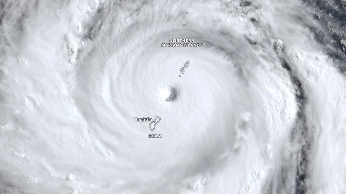
Satellite image of the eye of Category 5 super typhoon Bavi Over Rota, Northern Mariana Islands at 22:30 UTC on July 5, 2026. Credit: JMA/Himawari-9, Zoom Earth, The Watchers
The National Weather Service (NWS) in Guam issued a Tropical Cyclone Update warning of a “catastrophic damage and life-threatening situation” as the western eyewall of Super Typhoon Bavi moved over Rota at 06:54 ChST Monday, July 6 (20:54 UTC Sunday, July 5).
The agency reported maximum sustained winds of 290 km/h (180 mph) and warned that destructive winds exceeding 241 km/h (150 mph) would continue throughout the eyewall passage. An Extreme Wind Warning remained in effect for the island.
A Shelter-in-Place until “All Clear” was declared forRota, Tinian, and Saipan, and at 07:10 ChST on Monday (21:10 UTC on Sunday).
The storm’s eyewall had begun crossing Rota at 07:29 ChST Monday (21:29 UTC Sunday), according to the NWS, with the eye. At that time, the center of Bavi was located approximately 32 km (20 miles) east of Rota. It was moving west-northwest at 15 km/h (9 mph). 1-minute maximum sustained winds of 290 km/h (180 mph).
Typhoon-force winds extended outward up to 95 km (60 miles) from the center, while tropical-storm-force winds extended up to 370 km (230 miles) north of the center and 300 km (185 miles) south.
“We are hanging in there. We are experiencing heavy winds and flooding here… Some people are already reporting major damages,” the Rota Municipal Operations Center’s public information officer, Lou Rosario, said.
Severe damage was reported across the Northern Marianas, with homes and other structures being completely destroyed in some places.
Mayor Aubry Hocog confirmed in an interview with Mariana Press that no fatalities and injuries were reported as of Monday evening. There is extensive damage to government facilities and utility poles, particularly in the Song area, she reported. The Department of Public Works has been deployed to clear one-lane access routes to allow emergency responders to reach residents and medical facilities.
The Mayor is working with the Governor, FEMA, and homeland security partners. Engineers are expected to arrive to restore power via generators at the health center and school shelters, as well as to repair communication lines.
Previously, the NWS had warned that a direct hit on Rota would make most of the island “uninhabitable for weeks, perhaps longer.”
“Many non-concrete, non-reinforced homes will be destroyed, with total roof failure and wall collapse,” it said.
“Nearly all trees will be snapped or uprooted, and power poles will be downed. Fallen trees and power poles will isolate residential areas. Power outages will last for weeks to possibly months.”
Bavi posed an “imminent danger to life,” weather service meteorologist Edwin Montvila said, with the weather service telling residents across the islands to move to interior rooms and stay away from windows, Euro News reported.
“Entering outside can result in death from flying projectiles. Utility poles and associated power lines will be down,” Montvila added.
By 2:15 p.m. ChST Monday (04:15 UTC), the NWS reported that the eye had exited the western waters of Rota and Bavi was continuing west-northwest at 21 km/h (13 mph).
Although the threat from sustained typhoon-force winds was rapidly diminishing, the agency warned that frequent typhoon-force gusts would continue across portions of the Mariana Islands as the cyclone moved away.
Maximum sustained winds remained 282 km/h (175 mph), while the radius of typhoon-force winds had expanded to 113 km (70 miles).
“Tropical Storm conditions will continue on through the night as Typhoon Bavi pulls away. Please stay inside till we go into Condition of Readiness 4. This will be decided once we do an initial assessment of the conditions after the storm,” Guam Governor Lou Leon Guerrero said.
Bavi was located approximately 170 km (105 miles) west-northwest of Rota, and 193 km (120 miles) north-northwest of Guam, at 17:03 ChST Monday (07:03 UTC). The storm was moving west-northwest at 24 km/h (15 mph) and remained an extremely dangerous Category 5 super typhoon with maximum sustained winds of 282 km/h (175 mph).
Forecasters expect Bavi to remain at Category 5 intensity through Wednesday while gradually weakening as it continues away from the Marianas. Tropical-storm-force conditions were forecast to persist overnight before diminishing early Tuesday.
Typhoon Warnings remained in effect for Guam, Rota, Tinian, and Saipan, while a Tropical Storm Warning continued for Alamagan, and a Tropical Storm Watch remained in effect for Pagan and Agrihan.
The NWS also maintained Coastal Flood Warnings and High Surf Warnings for Guam, Rota, Tinian, and Saipan, while a Flood Watch remained in effect across Guam and the Northern Mariana Islands. The agency advised residents to monitor any Flood Warnings issued for their locations.
The NWS warned that hazardous conditions would persist after the center moved away. Forecast impacts included damage to roofs and siding, scattered power outages caused by downed power lines, snapped trees, dangerous surf, and additional flooding. Surf was forecast to reach up to 8 m (25 feet) around Rota and up to 6 m (20 feet) across Guam, Tinian, and Saipan.
Coastal wave run-up of 2 to 3 m (6 to 10 feet) remains possible depending on location. An additional 127 to 254 mm (5 to 10 inches) of rainfall was forecast across Guam, Rota, Tinian, and Saipan, with the potential for flash flooding and mudslides.
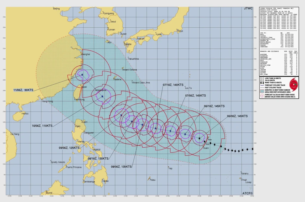
The Joint Typhoon Warning Center (JTWC) called Bavi a classic super typhoon with a well-defined 37 km (20 nautical miles) eye embedded within a nearly symmetrical central dense overcast.
Although sea surface temperatures of 30 to 31°C (86 to 88°F) remained favorable, forecasters said increasing easterly vertical wind shear and decreasing ocean heat content would begin a gradual weakening trend through Monday into Tuesday.
Bavi is forecast to continue tracking west-northwest through the Philippine Sea before gradually turning northwest around the southwestern edge of a subtropical ridge, according to the JTWC.
More significant weakening was expected later this week as the cyclone encountered lower sea-surface temperatures, decreasing ocean heat content, stronger vertical wind shear, and eventually interacted with the mountainous terrain of Taiwan.
Authorities urged residents to remain indoors until hazardous conditions fully subsided, warning that flooding, dangerous surf, and damaging wind gusts could continue even after the center of the cyclone had moved away from the Mariana Islands.
Updates
09:50 UTC, July 8
Super Typhoon Bavi continued moving west across the Philippine Sea on July 8 after leaving severe infrastructure damage on Rota, where officials said no fatalities or injuries had been reported.
At 03:00 UTC on July 8, the center of Bavi was located about 1 287 km (800 miles) west-northwest of Rota, with maximum sustained winds of 250 km/h (155 mph), according to NWS office in Guam. No tropical cyclone watches or warnings remained in effect for the Marianas.
CNMI Homeland Security and Emergency Management officials said Rota sustained the worst damage in the Commonwealth after the island took a direct hit from Bavi’s eye. First comprehensive damage assessments were underway, with officials reporting widespread damage to critical infrastructure, blocked roads, port concerns, power loss, and water-system damage.
Rota’s highest recovery priorities are restoring water access, clearing roads, and checking on residents’ overall condition. The Department of Public Works said crews were first clearing primary roads, roads to shelters and fire stations, and routes to seaports and the airport. A ruptured water transmission line from the Water Cave was also reported, with debris blocking access to parts of the damaged infrastructure.
The Commonwealth Ports Authority said Rota’s airport and seaport sustained the most significant transport damage in the CNMI. Preliminary work had cleared debris from the Rota airport runway, but the airport remained without commercial power, radio communications, weather reporting capability, and an operational windsock. Officials said restoring the airport was a priority for relief flights, supplies, and first responders.
The Rota West Harbor, which had already sustained damage during Super Typhoon Sinlaku, was undergoing further assessment after Bavi. Officials said additional damage was likely, but full inspections were still underway.
Bavi is forecast to maintain super typhoon intensity through Wednesday night before weakening through Friday as it turns northwest, roughly toward Taiwan.
References:
1 Super Typhoon Bavi (09W) Tropical Cyclone Update – NWS – July 6, 2026
2 Super Typhoon Bavi (09W) Local Statement – NWS – July 6, 2026
3 Super Typhoon Bavi (09W) Advisory Number 22 – NWS – July 6, 2026
4 Prognostic Reasoning for Super Typhoon Bavi (09W), Warning No. 22 – JTWC – July 6, 2026
5 ‘Major damage’ as Super Typhoon Bavi makes landfall on US Pacific islands – EuroNews – July 6, 2026

I am an Assistant Editor and Severe Weather & Science Journalist at The Watchers, specializing in real-time severe weather coverage, geophysical event reporting, and research-driven scientific analysis. You can reach me at rishav(at)watchers(.)news.

Commenting rules and guidelines
We value the thoughts and opinions of our readers and welcome healthy discussions on our website. In order to maintain a respectful and positive community, we ask that all commenters follow these rules.