
State of Emergency declared after flooding in Ōamaru, Red Warning covers Marlborough and Canterbury, New Zealand
A local state of emergency was declared in the Waitaki District after flooding affected Ōamaru, New Zealand, early July 6, 2026, as heavy rain, snow and strong winds disrupted parts of the South Island. A Red Heavy Rain Warning is now in force for Marlborough and Canterbury between Ward and Hanmer, and southeast of the Awatere Valley, including the Kaikōura ranges.
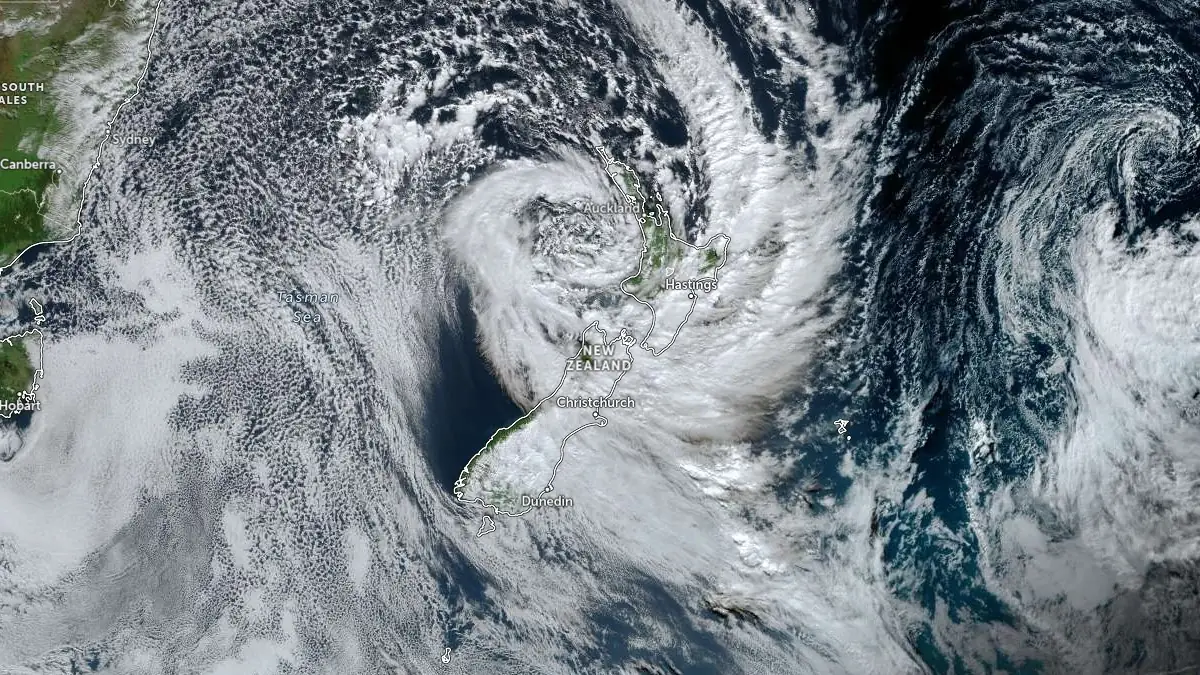
Satellite image acquired at 01:30 UTC on July 6, 2026. Credit: JMA/Himawari-9, Zoom Earth, The Watchers
The event follows the heavy rain and severe gale episode forecast by MetService on July 3, although the current phase is associated with a strong, cold southeast flow over the South Island and lower North Island.
Ōamaru received 34 mm (1.3 inches) of rain in about two hours, from around midnight to 02:00 NZST on July 6, resulting in flooding that affected homes and businesses and prompted more than 50 calls for assistance. Around 12 residents and four dogs were accommodated at the Network Waitaki Event Center after flooding affected properties in the town.
Surface flooding and road closures were also reported in Dunedin, where up to 160 mm (6.3 inches) of rain was reported during the event, the Taieri Plain, and the Clutha District.
Snow and ice caused further disruption across the inland and alpine parts of the South Island. Lake Tekapo and Mount Cook Village received around 25 cm (9.8 inches) of snow in 12 hours, while multiple state highways were closed or restricted because of snow, ice, flooding, fallen trees, and downed power lines.
The weather threat is now shifting northward.
At 20:13 NZST (08:13 UTC) on July 6, MetService said significant heavy rain, severe southeast gales, and snow were affecting parts of the South Island, while heavy rain was also becoming possible in Wairarapa on the lower North Island.
A Red Heavy Rain Warning is in force for Marlborough and Canterbury between Ward and Hanmer, and southeast of the Awatere Valley, including the Kaikōura ranges. The warning is valid for 31 hours from 20:00 NZST on July 6 to 03:00 NZST on July 8.
MetService forecasts a further 250 to 350 mm (9.8 to 13.8 inches) of rain, with isolated totals possibly reaching 400 mm (15.7 inches). Peak rainfall rates of 15 to 25 mm/h (0.6 to 1 inch/h) are expected from Monday night through Tuesday afternoon, particularly over the ranges.
Coastal locations in the Red Warning area may receive 80 to 120 mm (3.1 to 4.7 inches) during the same period. The freezing level is forecast near 1 600 m (5 250 feet), with snow likely above 1 200 m (3 900 feet).
MetService warned of a threat to life from dangerous river conditions, significant flooding and slips. Travel disruption, impassable roads, isolated communities, power outages and communications outages are possible.
‼️Red warnings‼️are in place for North Canterbury, & Marlborough (south of Ward to north of Hanmer) from Mon night–Wed AM. 250–350 mm of rain expected. Flooding, slips, power/comm outages likely. Other South Island & lower North Island areas under wind/rain warnings. #NewZealand pic.twitter.com/oIgF6RzCyT
— NIWA Weather (@NiwaWeather) July 6, 2026
An Orange Heavy Rain Warning is also in place for the Tasman District, about and west of Motueka, from 20:00 NZST on July 6 to 20:00 NZST on July 7. Rainfall totals of 120 to 150 mm (4.7 to 5.9 inches) are forecast for that area, with peak rates of 15 to 25 mm/h (0.6 to 1 inch/h) possible on Tuesday. MetService said there is a low chance of the warning being upgraded to Red.
Another Orange Heavy Rain Warning covers Marlborough about and north of Blenheim from 20:00 NZST on July 6 to 05:00 NZST on July 8. Forecast rainfall totals there are 130 to 180 mm (5.1 to 7.1 inches), with peak rates of 15 to 25 mm/h (0.6 to 1 inch/h) expected on Tuesday.
An additional Orange Heavy Rain Warning covers Marlborough south of Blenheim and Canterbury about and north of Lake Sumner, excluding the area already under the Red Warning. That warning is valid from 20:00 NZST on July 6 to 03:00 NZST on July 8. A further 170 to 200 mm (6.7 to 7.9 inches) of rain is forecast, with 60 to 100 mm (2.4 to 3.9 inches) expected near the coast. MetService said there is a high chance of that Orange Warning being upgraded to Red.
Canterbury from Geraldine to Lake Sumner, and areas west of Ashburton and Christchurch, are also under an Orange Heavy Rain Warning from 20:00 NZST on July 6 to 15:00 NZST on July 7. A further 100 to 140 mm (3.9 to 5.5 inches) is forecast over the foothills and high country, with 50 to 80 mm (2 to 3.1 inches) possible over the plains. Much of the precipitation is expected to fall as snow above 600 m (2 000 feet).
A Strong Wind Warning is in force for the West Coast south of Westport from 20:00 NZST on July 6 to 13:00 NZST on July 7. Severe southeast gales may reach 130 km/h (81 mph) in exposed valleys. MetService warned that the winds could damage trees, power lines and unsecured structures, while making travel hazardous, particularly for high-sided vehicles and motorcycles.
A Heavy Rain Watch covers Wairarapa, including the Tararua Range, from 06:00 NZST on July 7 to midnight on July 8. MetService said there is a high chance of that watch being upgraded to a warning.
Heavy snow remains possible south of the Rangitata River in South Canterbury, with a Heavy Snow Watch valid through 05:00 NZST on July 7. Snowfall may approach warning criteria above 700 m (2 300 feet), with lesser accumulations possible down to 400 m (1 300 feet).
Road Snowfall Warnings are in effect for Arthur’s Pass and Porters Pass on State Highway 73. Up to 1 cm (0.4 inches) of snow may accumulate above 800 m (2 625 feet) at Arthur’s Pass, while 10 to 15 cm (3.9 to 5.9 inches) is possible near the Porters Pass summit.
Residents in warning areas are advised not to enter floodwaters, avoid unnecessary travel, monitor local authority information and be prepared to self-evacuate if water levels rise.
Update
10:01 UTC, July 8
States of emergency remained in place for Waitaki and Kaikōura districts on July 8 as response teams continued damage assessments after severe rain and flooding affected parts of New Zealand’s South Island.
In Kaikōura, officials said weather conditions had eased and floodwaters were receding, although further rainfall was still forecast. Response teams remained on the ground assessing damage to roads, bridges, and other infrastructure in areas including Oaro, Kekerengū, Hapuku, Puhi Puhi, Blue Duck Valley, and Peketa.
Road closures remained in place across the district, including sections of State Highway 1 north and south of Kaikōura. Officials said NZTA was continuing structural assessments of key transport routes and that roads would remain closed until they could be confirmed safe.
A boil water notice was issued for Peketa, and residents were urged to conserve water. Kaikōura District Council said people who self-evacuated could return home if their property had not been damaged and they were not subject to an official evacuation request.
Marlborough Emergency Management said it was moving into the recovery phase after three days of heavy rain. Two rural communities remained isolated because of damaged roads on Awatere Valley Road and Tyntesfield Road in the Waihopai Valley, where floodwater severely damaged the approach to a bridge.
Marlborough officials said river levels were expected to continue falling, but local roads remained closed. Nine people were safely relocated from Blenheim Bridges Holiday Park after floodwater from the Ōpaoa River entered the lower part of the campground.
Authorities said Kaikōura received about two months’ worth of rain in 48 hours during the event. Marlborough District Council said this was expected to be its final emergency-response update, with recovery support now continuing for affected communities.
References:
1 Severe Weather Warnings – MetService – Issued 20:13 NZST on July 6, 2026
2 Flooding and snow affect Otago region – Otago Regional Council – Accessed July 6, 2026
3 Update: Here we go again. Bad weather on the way for Lower North Island and Top of the South highways (SH63 closed by treefalls) – NZ Transport Agency – Accessed July 6, 2026

I'm a dedicated researcher, journalist, and editor at The Watchers. With over 20 years of experience in the media industry, I specialize in hard science news, focusing on extreme weather, seismic and volcanic activity, space weather, and astronomy, including near-Earth objects and planetary defense strategies. You can reach me at teo /at/ watchers.news.

Commenting rules and guidelines
We value the thoughts and opinions of our readers and welcome healthy discussions on our website. In order to maintain a respectful and positive community, we ask that all commenters follow these rules.