
SPC forecasts damaging winds, large hail and tornadoes across parts of Midwest and East
The Storm Prediction Center issued an Enhanced Risk for severe thunderstorms across parts of the Upper Midwest and Great Lakes on Monday, July 20, 2026. A second Enhanced Risk covers parts of the Ohio Valley, Mid-Atlantic, and Northeast on Tuesday, July 21, with damaging winds, large hail, and tornadoes all possible.
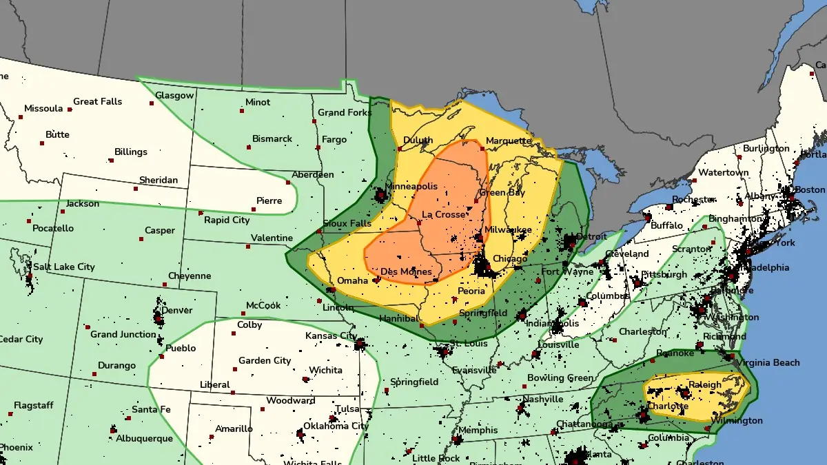
SPC Enhanced Risk of severe thunderstorms for July 20, 2026. Credit: NWS/SPC
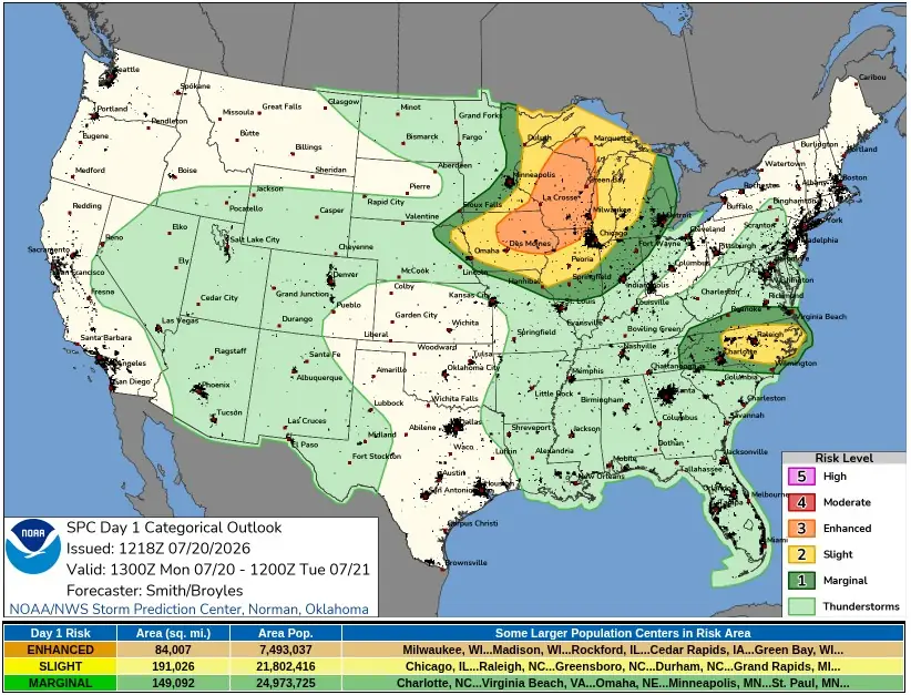
The Storm Prediction Center issued an Enhanced Risk for severe thunderstorms across parts of the Upper Midwest and Great Lakes for Monday, July 20. Severe thunderstorms are expected especially late Monday afternoon and Monday night, with swaths of damaging winds, large hail, and a few tornadoes possible. Isolated damaging wind gusts are also forecast over parts of the Carolinas and southern Virginia.
A second SPC Enhanced Risk covers Tuesday, July 21, from parts of southern Indiana, northeast Kentucky, southern and eastern Ohio, West Virginia, northern Virginia, Maryland, and Pennsylvania. The Day 2 outlook covers a broader severe weather corridor from the Ohio Valley into the Mid-Atlantic and Northeast. SPC warned all severe hazards are possible, while swaths of damaging wind gusts are expected to be the primary severe risk Tuesday afternoon into Tuesday night.
Monday’s severe weather setup developed behind a morning convective system over far northern Iowa and west-central Wisconsin.
SPC analyzed warm-advection-related storms moving east-southeast over the cooler air left behind by a morning mesoscale convective system, or organized thunderstorm complex, downstream of a seasonably strong mid-level shortwave trough and associated jet streak.
The northern risk corridor depends on recovery after the morning convection. SPC forecast a warm and seasonably moist air mass to move northeast into Wisconsin, where surface dew points near 20 to 24°C (upper 60s to lower/middle 70s°F) were expected to support a very unstable boundary layer by mid- to late afternoon. The agency kept uncertainty in the forecast because morning storms could affect downstream destabilization and later hazard placement.
Storms that develop later Monday afternoon could organize into supercells along and ahead of the cold front where strong deep-layer shear overlaps with ample buoyancy, according to SPC. The agency placed the large hail and tornado risk corridor from Iowa across Wisconsin into Upper Michigan. Forecast soundings showed elongated hodographs and 700 hPa flow of about 65 to 93 km/h (40 to 58 mph; 35 to 50 kt) — an environment that could support a couple of strong tornadoes if later mesoscale details align.
The Day 1 probabilistic outline includes a 30% wind risk area within the Enhanced Risk corridor across parts of Iowa, Illinois, Wisconsin, and Upper Michigan. A surrounding 15% wind risk area extends from the Upper Midwest into parts of Michigan and adjacent areas, while a separate 15% wind risk area covers parts of North Carolina and far southern Virginia.
SPC also outlined 15% hail probabilities across parts of the Upper Midwest and Great Lakes and tornado probabilities up to 5% within the main northern risk corridor.
Farther southeast, the Carolinas and southern Virginia are under a separate damaging wind threat Monday afternoon and evening. SPC forecast strong heating south of a stalled west-east front, surface dew points above 21°C (in the 70s°F), and high precipitable water profiles capable of supporting water-loaded downdrafts in stronger thunderstorm cores. The main timing for scattered storms in that corridor is from 18:00 UTC on July 20 to 00:00 UTC on July 21.
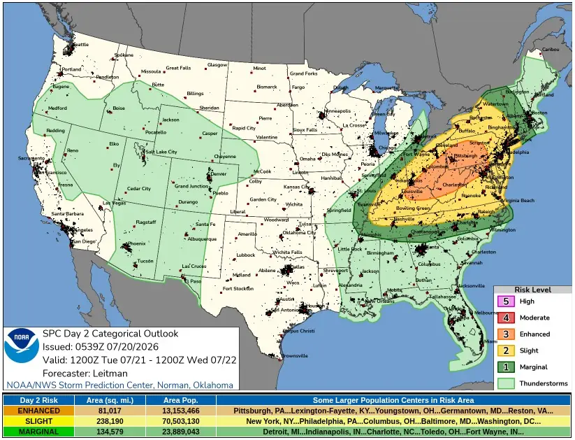
The severe weather risk shifts east and southeast Tuesday, July 21 as an upper trough remains over the region and several shortwave impulses move through the larger-scale system. SPC forecasts surface low pressure to move across southern Ontario into Quebec while a trailing cold front advances across much of the Midwest.
Ahead of the front, prefrontal troughing is expected across western and central New York into the Mid-Atlantic, with surface dew points near 18 to 22°C (mid-60s to low 70s°F) supporting moderate to strong instability.
Wind fields are forecast to remain strong for late July, with 500 hPa flow of about 74 to 111 km/h (46 to 69 mph; 40 to 60 kt) and 850 to 700 hPa flow of about 56 to 93 km/h (35 to 58 mph; 30 to 50 kt). Forecast soundings support supercell wind profiles, with curved low-level hodographs becoming elongated above 2 to 3 km 1.2 to 1.9 miles).
The expected storm mode includes a mix of supercells and one or more bowing linear segments across the Ohio Valley into the Mid-Atlantic, although there’s still uncertainty around convective evolution.
The Day 2 probabilistic outline includes a 45% wind risk area across parts of Kentucky, Ohio, West Virginia, Pennsylvania, Maryland, and Virginia. A broader 30% wind risk area extends from the lower Ohio Valley into the Mid-Atlantic coast. SPC included 15% hail probabilities and a 5% tornado risk area across parts of the Ohio Valley, Appalachians, Mid-Atlantic, and Pennsylvania.
Significant severe potential on Tuesday, including hail of 5 cm (2 inches) or larger and wind gusts of 120 km/h (75 mph) or stronger, remains unclear and will depend on storm mode and mesoscale evolution, SPC forecasters said.
Warm temperatures aloft could limit significant hail potential. Gusts of 120 km/h (75 mph) or stronger could occur if a well-organized bowing structure and stronger cold pool develop, but confidence in that higher-end scenario was low in the 06:00 UTC Day 2 outlook.
References:
1 Day 1 Convective Outlook – NWS/SPC – July 20, 2026
2 Day 2 Convective Outlook – NWS/SPC – July 20, 2026

I'm a dedicated researcher, journalist, and editor at The Watchers. With over 20 years of experience in the media industry, I specialize in hard science news, focusing on extreme weather, seismic and volcanic activity, space weather, and astronomy, including near-Earth objects and planetary defense strategies. You can reach me at teo /at/ watchers.news.

Commenting rules and guidelines
We value the thoughts and opinions of our readers and welcome healthy discussions on our website. In order to maintain a respectful and positive community, we ask that all commenters follow these rules.