
CPC posts a slight risk of heavy rain from the Gulf Coast to the Northeast urban corridor November 25-29, and a moderate risk of West Coast wind and Sierra snow on November 25
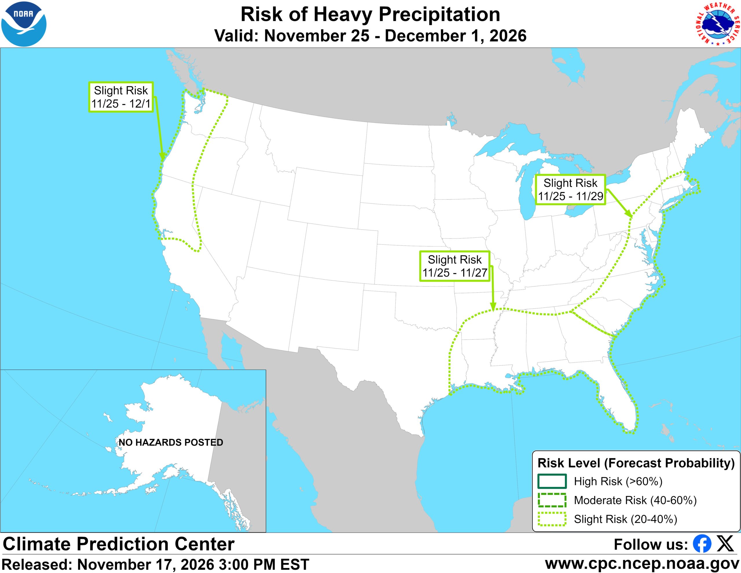
The Climate Prediction Center has posted a slight risk of heavy precipitation from the Gulf Coast to the Northeast urban corridor around Thanksgiving week, and a moderate risk of high winds and heavy mountain snow on the West Coast on Wednesday, November 25, 2026. The week-2 U.S. hazards outlook, issued at 15:00 EST on Tuesday, November 17, is valid from November 25 to December 1. On CPC’s precipitation hazards map, a slight risk is the 20 to 40 percent forecast-probability category.
CPC lists a slight risk of heavy precipitation for much of the Gulf Coast east of Houston, as well as much of the Tennessee and Lower Mississippi Valleys and the Southeast, from Wednesday, November 25, through Friday, November 27. A separate slight risk covers much of the Mid-Atlantic and the Northeast urban corridor from November 25 to 29. The center said surface high pressure over the Great Lakes and developing low pressure over the Southern Plains are expected to draw moist air north from the Gulf, raising the chance of heavy rain along parts of the Gulf Coast and the Eastern Seaboard. It cited uncalibrated GEFS and ECMWF model probabilities of at least 40 percent that 3-day rainfall will exceed 1 inch across a wide swath from the Gulf Coast up the East Coast into New England through the middle of the week.
In the West, CPC posted a moderate risk of high winds along the Pacific coast from Cape Mendocino north to the U.S.-Canada border on November 25, and a moderate risk of heavy snow over the Klamath and Sierra Nevada mountains that same day. A slight risk of heavy precipitation remains in effect for western Washington and Oregon and much of California north of the Bay Area from November 25 to December 1, with a slight risk of heavy snow over the Cascades, Klamath and Sierra Nevada through that period, and over the Wasatch Range and the northern and central Rockies from November 25 to 28. A slight risk of high winds covers much of the country west of the Rockies from November 25 to December 1.
CPC discontinued the moderate risk of heavy precipitation that it had posted in the previous outlook, saying chances for enhanced rain early in week-2 had decreased. Watchers coverage of that earlier outlook had described a moderate risk of heavy rain, mountain snow and high winds for northern California and southwest Oregon on November 24-25. The new outlook keeps the moderate snow and wind risks for November 25 only.
In the discussion, CPC said uncalibrated GEFS and ECMWF probabilities still show at least a 50 percent chance of more than an inch of rain on November 25 over the early West Coast storm, and greater than 50 percent chances that 3-day totals will exceed 2 inches early in the period. For mountain snow, it cited greater than 40 percent chances that 3-day snowfall will exceed a foot over the Sierra Nevada early in week-2, and greater than 60 percent chances of more than 6 inches during the week in the Cascades, Sierra and Klamath ranges. The center did not issue a flooding hazard, though it said isolated urban, small-stream or local river flooding is possible in parts of Central California given the expected week-2 rainfall totals.
Featured image: Climate Prediction Center Days 8-14 risk of heavy precipitation, valid November 25 to December 1, 2026, issued at 15:00 EST on November 17. Credit: NOAA/NWS Climate Prediction Center, public domain
Sources: CPC U.S. Week-2 Hazards Outlook (issued 15:00 EST, November 17, valid November 25 to December 1), CPC Days 8-14 heavy precipitation risk map

The Watchers Staff covers earthquakes, volcanoes, severe weather, space weather and other natural events. Published since 2011, The Watchers reports on a changing planet and the science behind it.
Published in the last 24 hours
- The storms drenching California this week are fed by a river in the sky, a band of water vapor that can carry up to 15 times the flow of the Mississippi River, and this winter’s near-record El Niño could keep aiming more of them at the West Coast
- Florida's east coast faces a moderate flash flood risk Wednesday through Friday, with 4 to 8 inches of rain forecast and the St. Johns River near Cocoa already in major flood at 17.13 feet
- Cyclone Akvan to make landfall between Nellore and Visakhapatnam around noon on November 20, IMD forecasts 120-130 km/h winds gusting to 145
- Radio pulses every 7.9 minutes reveal binary with white dwarf and Sun-like star Epicenter
