
Atmospheric river brings moderate risk of heavy rain, mountain snow and high winds to northern California and southwest Oregon on November 24-25
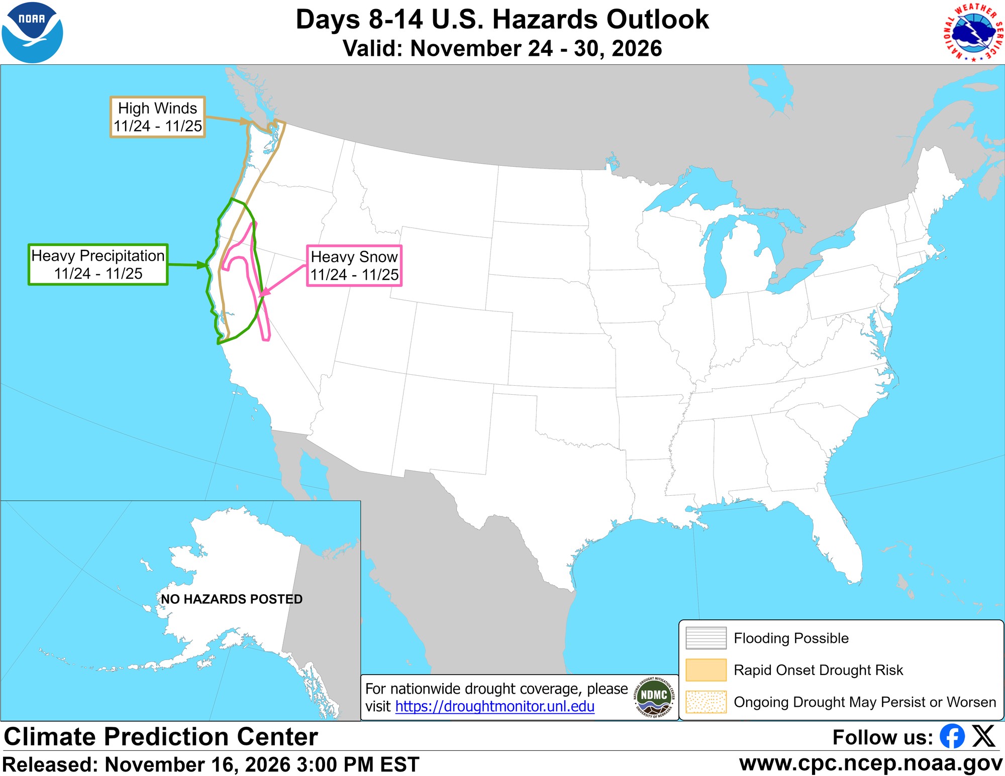
A pulse of Pacific moisture is expected to bring a moderate risk of heavy rain, mountain snow and high winds to northern California and southwestern Oregon on Tuesday and Wednesday, November 24-25, 2026, according to the Climate Prediction Center’s week-2 hazards outlook issued at 15:00 EST on November 16 (04:00 SGT on November 17). The outlook cites a sharp pulse of integrated vapor transport exceeding 250 kg/m/s over northern California and southern Oregon early in the period, a concentrated plume consistent with a strong atmospheric river.
This system is separate from the two atmospheric rivers already expected to affect California from late November 17 through about November 20.
CPC posted a moderate risk of heavy precipitation for much of northern California and southwestern Oregon on November 24-25, a moderate risk of heavy snow for the Klamath and northern Sierra Nevada, and a moderate risk of high winds along the Pacific coast from Monterey Bay north to the U.S.-Canada border. A slight risk of heavy rain, mountain snow and high winds then continues across a broader stretch of the West through November 30.
The outlook said uncalibrated probabilities from the GEFS and ECMWF ensembles showed at least a 50% chance of more than 25 mm (1 inch) of rain in a day on November 24-25, and a greater than 50% chance that three-day totals would exceed 51 mm (2 inches). For the Sierra Nevada, the same ensembles showed a greater than 40% chance of more than 30 cm (1 foot) of snow in three days early in the period, and a greater than 60% chance of more than 15 cm (6 inches) over the Cascades, Sierra Nevada and Klamath Range during the week. The Weather Prediction Center’s day 3-7 hazards outlook, valid only through November 23, had not yet issued official rainfall or snowfall totals for November 24-25.
Farther east, CPC posted a slight risk of heavy precipitation from the Gulf Coast east of Houston through the Tennessee and Lower Mississippi valleys and the Southeast from November 24 to 28, and for the Mid-Atlantic and Northeast urban corridor from November 26 to 28, overlapping the U.S. Thanksgiving holiday on November 26. A slight risk of high winds was also posted for the Mid-Atlantic and Northeast from November 24 to 27.
Local National Weather Service offices will issue more detailed forecasts as the system moves into the shorter-range window.
Featured image: Climate Prediction Center Days 8-14 U.S. Hazards Outlook, valid November 24-30, 2026, issued at 15:00 EST on November 16. Credit: NOAA/NWS Climate Prediction Center, public domain
Sources: CPC Week-2 Hazards Outlook, WPC Day 3-7 Hazards Outlook

The Watchers Staff covers earthquakes, volcanoes, severe weather, space weather and other natural events. Published since 2011, The Watchers reports on a changing planet and the science behind it.
Published in the last 24 hours
- 190 mm of rain and 131 km/h gusts hit New Zealand's South Island, flooding West Coast highways
- Huge waves pummel California coast during strong El Niño, flooding streets and closing piers from Pacifica to San Diego
- 2 atmospheric rivers to bring heavy Sierra snow and California flood risk
- Right about now, Voyager 1 is crossing a line no human-made object has ever reached, a full light-day from Earth, which means a message NASA sends tonight won't arrive until tomorrow night, and the spacecraft's answer won't make it home until the night after that
