
Bay of Bengal system to become Cyclone Akvan, landfall forecast between Nellore and Tuni on November 20, India
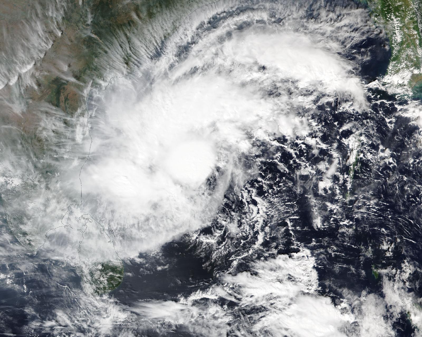
A deep depression over the southern Bay of Bengal is expected to strengthen into Cyclone Akvan and then into a very severe cyclonic storm before crossing the Andhra Pradesh and Yanam coasts between Nellore and Tuni around 11:30 IST (06:00 UTC) on Friday, November 20, 2026. The India Meteorological Department (IMD) forecasts maximum sustained winds of 120 to 130 km/h (75 to 80 mph), gusting to 145 km/h (90 mph), at landfall.
The system would be the third cyclone to threaten the Andhra Pradesh coast in about four weeks, after very severe cyclonic storm Arnab came ashore near Narsapur on October 28 and severe cyclonic storm Murasu crossed the coast near Ongole.
Where the system is now
At 06:00 UTC (11:30 IST) on November 16, the deep depression was centered near 11.7°N, 86.0°E over the southeast and adjoining southwest Bay of Bengal, according to the IMD tropical weather outlook issued at 10:30 UTC. That placed it about 650 km (405 miles) east-southeast of Chennai, 730 km (455 miles) south-southeast of Visakhapatnam, 620 km northeast of Trincomalee in Sri Lanka and 850 km south of Gopalpur in Odisha.
The system moved north-northwest at 17 km/h (11 mph) during the previous six hours. IMD estimated its central pressure at 1 002 hPa and its maximum sustained winds at 30 knots (55 km/h), gusting to 40 knots. Satellite data showed intense to very intense convection west and northwest of the center, with cloud-top temperatures as low as -90°C.
The name Akvan will be assigned once the depression reaches cyclonic storm strength, following the list maintained by the WMO/ESCAP Panel on Tropical Cyclones. IMD expects that to happen around 12:00 UTC (17:30 IST) on November 16. At the time of writing, IMD had not yet announced the upgrade.
Forecast track and intensity
IMD forecasts the system to keep moving north-northwest and become a severe cyclonic storm over the west-central Bay of Bengal around 12:00 UTC on November 17. It is then expected to turn west-northwest and reach very severe cyclonic storm strength late on November 19, before crossing the coast on November 20. IMD’s forecast table shows winds of 115 to 125 km/h, gusting to 140 km/h, by 18:00 UTC on November 19, peaking at 120 to 130 km/h, gusting to 145 km/h, at 06:00 UTC on November 20, and easing to 90 to 100 km/h over land by 18:00 UTC that day.
The landfall window covers roughly 500 km (310 miles) of coastline between Nellore in the south and Tuni in the north, with Machilipatnam near the middle. IMD rated its confidence in the forecast track and intensity as moderate to high, but noted considerable divergence among models on later movement, intensification, landfall location and timing. Most models indicate a west-northwestward track across the Andhra Pradesh coast. Earlier IMD outlooks pointed further north, and the department now places landfall on central and south coastal Andhra Pradesh.
The U.S. Joint Typhoon Warning Center (JTWC) issued a Tropical Cyclone Formation Alert for the system, tracked as Invest 92B, at 07:21 UTC on November 16 and rated the chance of a significant tropical cyclone forming within 24 hours as high. JTWC said sea surface temperatures of 29 to 30°C and strong upper-level outflow favor development, while moderate to high vertical wind shear of 20 to 25 knots is working against it.
IMD added that the Madden-Julian Oscillation is in phase 3 with an amplitude above 1 and is expected to support convection over the Bay of Bengal from November 16 to 21.
Warnings and preparations
IMD has issued a pre-cyclone watch for the Andhra Pradesh and adjoining south Odisha coasts. Squally winds of 40 to 50 km/h, gusting to 60 km/h, are likely along the Andhra Pradesh and Yanam coasts through November 17 and are expected to strengthen to gale force as the system intensifies. Sea conditions are forecast to be rough to very rough through November 17 and worsen after that.
Fishermen in Andhra Pradesh have been told not to go to sea until November 20, and district administrations have advised a complete halt to offshore operations, The Hindu reported. Fisheries Joint Director L.B.S. Vardhan told the paper that Cyclone Arnab caused ₹307 lakh in damage to fisheries in Visakhapatnam district alone, and that compensation is still awaited.
In neighboring Odisha, authorities alerted all 30 districts, opened 24-hour control rooms and put NDRF, ODRAF and fire service teams on standby, according to Moneycontrol, citing state officials.
A busy season for the Andhra coast
Arnab made landfall as a very severe cyclonic storm and left 3 people dead in Andhra Pradesh. Its remnants then dropped more than 546 mm (21 inches) of rain on parts of Odisha, cutting off around 300 villages. Krishna district, which includes Machilipatnam, was largely spared by Arnab and Murasu but was devastated by the 1977 Diviseema cyclone.
October to December is the main post-monsoon cyclone season in the Bay of Bengal. In 2025, Cyclone Montha struck the same coast in late October, leaving 2 dead and around 50 000 ha (123 000 acres) of crops destroyed.
IMD issues updated bulletins several times a day, and the forecast landfall point may shift as the system develops.
Featured image: The deep depression over the Bay of Bengal on November 16, 2026, seen by the VIIRS instrument on NOAA-20. Credit: NASA Worldview / NOAA-20 VIIRS, public domain
Sources: IMD tropical weather outlook, 06:00 UTC November 16, IMD tropical weather outlook, 00:00 UTC November 16, IMD cyclone bulletins, JTWC, The Hindu, Hindustan Times, Moneycontrol

The Watchers Staff covers earthquakes, volcanoes, severe weather, space weather and other natural events. Published since 2011, The Watchers reports on a changing planet and the science behind it.
Published in the last 24 hours
- Tropical Cyclone Xavier reaches Category 2 over Northern Cook Islands, gale warning for Manihiki and Rakahanga
- El Niño floods kill 2 in Guayaquil as 172.8 mm of rain swamps Milagro, Ecuador's toll rises to 14
- Southern Thailand braces for heavy rain, 15 provinces on flood and landslide alert for November 18-22
- Paraná River floods force 4 547 from homes as water tops evacuation levels in 10 Argentine towns
