
10 named storms, one hurricane for the first time since 1925: Why has the Atlantic been so quiet in 2026
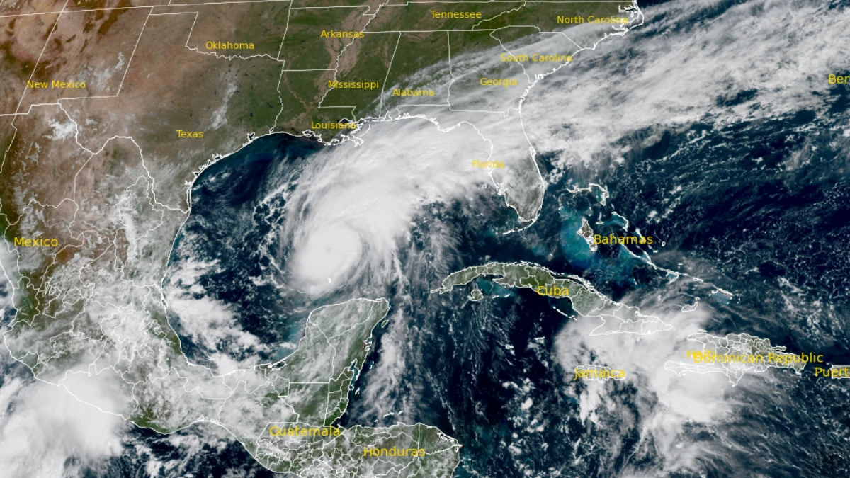
The Atlantic had produced 10 named storms by November 15, 2026, but only one hurricane: Isaias. Strong El Niño conditions have made it harder for storms to strengthen, helping keep the basin unusually quiet with just over two weeks left in the official season.
An average Atlantic season produces about seven hurricanes. Isaias was the exception in a year when most storms struggled to strengthen. It formed on October 8 and soon reached Category 3 over the Gulf before weakening and striking the Florida Panhandle as a Category 2 hurricane. Its flooding and power outages showed how a quiet season can still bring damaging weather ashore.
A large shortfall in hurricane formation
The difference is clearest among systems that strengthened beyond tropical-storm intensity. An average Atlantic season produces seven hurricanes, compared with one so far in 2026.
The NHC’s running accumulated cyclone energy (ACE) index was also listed as 83% below normal in its 1991–2020 comparison. ACE combines the intensity and duration of storms by summing squared wind speeds at six-hour intervals. It measures seasonal storm activity, rather than damage on land.
| Measure | As of November 15, 2026 | 1991–2020 full-season average |
|---|---|---|
| Named storms | 10 | 14 |
| Hurricanes | 1 | 7 |
| Major hurricanes | 1 | 3 |
The first hurricane arrived after the usual peak
Isaias became a hurricane over the Gulf at 03:30 UTC on October 8, or 22:30 CDT on October 7. Dropsonde data from an Air Force Reserve Hurricane Hunter aircraft prompted the NHC’s operational upgrade, with estimated sustained winds of 120 km/h (75 mph).
The basin’s first hurricane typically arrives around August 11, according to the NHC’s 1991–2020 benchmark dates. In the record since 1966, the previous latest first hurricanes were Gustav in 2002 and Humberto in 2013, both on September 11. Isaias arrived nearly four weeks later.
The older comparison needs consistent clocks. NHC’s historical HURDAT2 database places 1905’s first hurricane at 00:00 UTC on October 8; Isaias’s operational upgrade also fell on October 8 UTC. Comparing October 7 local time in 2026 with October 8 UTC in 1905 creates a misleading one-day difference.
The satellite-era record is clear. A precise comparison of hurricane-onset times across 121 years is less secure, particularly while Isaias’s operational estimates remain subject to post-storm analysis.
How El Niño made development harder
El Niño changes atmospheric circulation well beyond the tropical Pacific. Over the Caribbean and tropical Atlantic, it often increases vertical wind shear: the change in wind speed or direction with height.
Strong shear can displace thunderstorms from a developing cyclone’s circulation center, making it harder for the system to organize and strengthen. Warm water supplies energy, but the atmosphere must also allow that heat to sustain an organized storm.
In an October 28 analysis, hurricane specialist Michael Lowry reported that August–September wind shear over the Caribbean averaged 37 knots, approximately 69 km/h (43 mph), compared with a 30-year average of 25 knots, approximately 46 km/h (29 mph). These figures describe differences in wind with height, not surface wind gusts.
Lowry also identified widespread sinking air and weaker disturbances moving off Africa as additional obstacles. The season’s suppression therefore involved several atmospheric conditions, rather than a single wind measurement.
A strong El Niño does not dictate every season
NOAA’s November 12 assessment said El Niño continued to strengthen, with a probability above 79% of strong-to-very-strong conditions through January–March 2027. That describes the Pacific climate pattern; it does not determine the fate of every Atlantic disturbance.
The contrast with 2023 is useful. A peer-reviewed analysis of that season documented seven Atlantic hurricanes despite strong El Niño conditions. Record-warm tropical Atlantic waters helped counteract the usual El Niño influence, while peak-season wind shear was below normal.
For 2026, NOAA’s August outlook favored a below-normal season and forecast two to six hurricanes, with a 70% probability assigned to that range. The tally remains below its lower bound, although a probabilistic forecast range is not an absolute limit and the season is still in progress.
The quiet season still brought damaging weather
Isaias reached peak sustained winds near 195 km/h (120 mph), Category 3 strength, before weakening. It made landfall near Destin, Florida, on the evening of October 9 local time as a Category 2 hurricane, with sustained winds near 170 km/h (105 mph).
The Florida landfall brought flooding, fallen trees, and widespread power outages, with damaging weather extending inland across the Southeast.
NASA’s Black Marble HD imagery showed reduced nighttime lighting around Pensacola and along the coast toward Destin on October 11, compared with an August composite. Hatched areas indicate missing observations because of clouds; they should not be interpreted as outages.
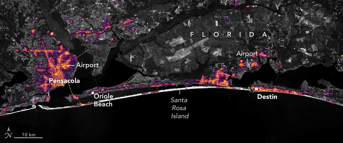
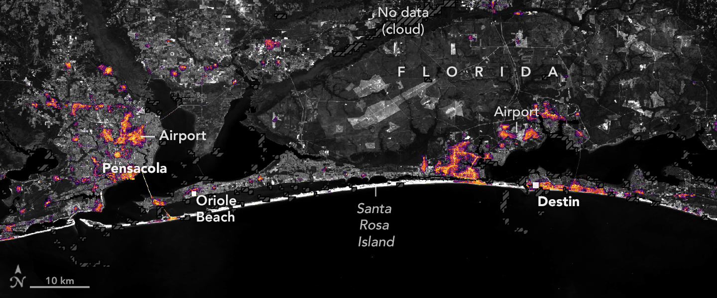
In NOAA’s May 21 seasonal outlook, National Weather Service Director Ken Graham said: “It only takes one storm to make for a very bad season.” Isaias demonstrated why the basin-wide total and the experience of communities in a storm’s path can differ so sharply.
The final hurricane tally remains open
If no other hurricane develops, 2026 would finish every completed season below from 1966 through 2025 in the NHC record. The lowest hurricane totals in that period were two, in 1982 and 2013.
The historical database lists 1925 as the most recent completed season with only one hurricane. Earlier counts are less certain because storms over the open ocean could escape observation before routine satellite surveillance.

AccuWeather’s November 11 assessment concerned the end of the threat of additional direct tropical impacts to the United States. It explicitly allowed for storms elsewhere in the Atlantic. That forecast does not close the basin’s season, which officially continues through November 30; tropical cyclones can also occur outside those calendar limits.
References
1 National Hurricane Center. 2026 Atlantic Hurricane Season: North Atlantic Tropical Weather Summary. Summary as of 09:00 UTC, November 15, 2026. Operational figures remain subject to revision.
2 Papin/Roberts, National Hurricane Center. Hurricane Isaias Tropical Cyclone Update, AL092026 / MIATCUAT4. October 8, 2026, 03:30 UTC; October 7, 22:30 CDT.
3 National Hurricane Center. Tropical Cyclone Climatology. Seasonal averages and benchmark dates based on 1991–2020. Accessed November 15, 2026.
4 National Hurricane Center. Atlantic hurricane database, HURDAT2, 1851–2025. Version dated September 23, 2026. Historical counts and first hurricane dates checked from the data; 2026 operational observations are separate.
5 U.S. Geological Survey. El Niño and Hurricanes. Climate Adaptation Science Centers. Accessed November 15, 2026.
6 Lowry, M. 2026. One Factor Stands Out in Making 2026 One of the Least Active Atlantic Hurricane Seasons on Record. Eye on the Tropics, October 28, 2026. Attributed meteorological analysis.
7 NOAA Climate Prediction Center. El Niño/Southern Oscillation Diagnostic Discussion. November 12, 2026.
8 Klotzbach, P. J., et al. 2024. The 2023 Atlantic Hurricane Season: An Above-Normal Season despite Strong El Niño Conditions. Bulletin of the American Meteorological Society. NOAA repository copy.
9 NOAA Climate Prediction Center. 2026 Atlantic Hurricane Season Outlook, August update. Forecast ranges and probabilities; not a landfall forecast.
10 NASA Earth Observatory. 2026. Isaias Dims the Gulf Coast. October 16, 2026.
11 NOAA. 2026. NOAA predicts below-normal 2026 Atlantic hurricane season. May 21, 2026. Source of the contemporaneous Ken Graham quotation.
12 Greenwood, J. K. / AccuWeather. 2026. 2026 Atlantic Hurricane Season: AccuWeather Experts Say U.S. Tropical Threat Has Ended. Published November 11, 2026, 21:26 UTC.
13 U.S. Geological Survey. 2026. Hurricane Isaias Animation from USGS VizLab. October 20, 2026. Public-domain visualization.

Rishav Kothari is Editor-in-Chief of The Watchers, where he runs the newsroom and covers earthquakes, volcanoes, severe weather and space weather.
Published in the last 24 hours
- Amazon fire hotspots rise 82.6% in October 2026 as El Niño intensifies Epicenter
- In 2005, a driver near Russia's Chulyshman River picked up a stone to wedge under his car wheel and kept it for 20 years; the Meteoritical Bulletin has now approved it as the Altai Republic's first meteorite. Epicenter
- The Leonid meteor shower peaks on the night of November 17, exactly 60 years after the 1966 storm, when some observers reported meteors falling at up to 40 a second, though this year’s show should be closer to 15 an hour
- When Arctic air reached South Florida in January 2020, Miami fell to 40°F and the National Weather Service warned residents to watch for cold-stunned iguanas dropping out of the trees Epicenter
