
Life-threatening storm surge of up to 2 m (7 feet) forecast as Hurricane Isaias approaches U.S. Gulf Coast
Life-threatening storm surge is forecast along the northern U.S. Gulf Coast as Hurricane Isaias approaches landfall. NHC said water could rise 1.5–2 m (5–7 feet) above ground between Ocean Springs, Mississippi, and Indian Pass, Florida, and within Mobile Bay if the peak surge coincides with high tide.saias is forecast to produce 75–180 mm (3–7 inches) of rain from southeastern Louisiana to Florida’s Big Bend from Friday through the weekend, with localized totals approaching 380 mm (15 inches) in the Florida Panhandle and Big Bend. NHC warned of considerable flash and urban flooding and significant river flooding.
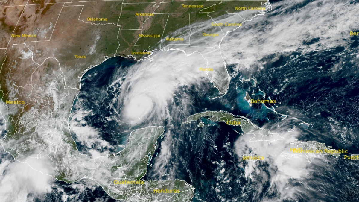
Satellite image of Hurricane Isaias on October 8, 2026. Credit: NOAA/GOES-East, The Watchers
At 18:00 UTC, the center of Isaias was located approximately 300 km (185 miles) north of Progreso, Mexico, and 570 km (355 miles) south of the mouth of the Mississippi River.
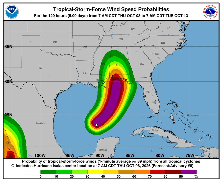
The hurricane was moving east-northeast at 17 km/h (10 mph), with a minimum central pressure of 975 hPa. Hurricane-force winds extended approximately 28 km (17 miles) from the center, while tropical-storm-force winds extended up to 150 km (90 miles).
Isaias reached hurricane strength at 22:30 CDT on October 7 (03:30 UTC on October 8), when Air Force Reserve Hurricane Hunter observations measured sustained winds of 120 km/h (75 mph). The Hurricane and Storm Surge Warnings had been issued shortly before the upgrade.
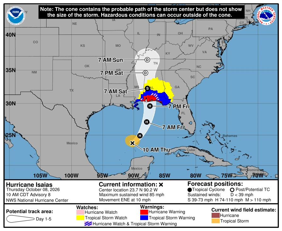
NHC forecasts Isaias to turn northeastward before moving northward on Friday. The cyclone is expected to make landfall along the northern U.S. Gulf Coast within the warning area late Friday, October 9, or early Saturday, October 10.
Additional strengthening is forecast through early Friday. NHC’s Advisory 8 intensity forecast brings Isaias to approximately 175 km/h (110 mph), near the upper limit of Category 2 intensity, by 12:00 UTC on October 9.
Increasing vertical wind shear could produce some weakening as Isaias approaches the coast. NHC nevertheless expects the cyclone to remain a dangerous hurricane through landfall.
A microwave satellite image showed a closed ring around the developing eye, which NHC identified as a feature that can precede rapid intensification. Additional reconnaissance missions were scheduled through Friday to monitor the cyclone’s intensity.
A Storm Surge Warning is in effect from the mouth of the Mississippi River to the Suwannee River, Florida. NHC called it a life-threatening situation and urged residents to promptly follow evacuation and other instructions from local officials.
If the peak surge occurs at the time of high tide, water could reach 1.5 to 2 m (5 to 7 feet) above ground from Ocean Springs, Mississippi to Indian Pass, Florida, and within Mobile Bay.
Surge heights of 1.2 to 1.8 m (4 to 6 feet) are possible from Indian Pass to the Steinhatchee River, and 1 to 1.5 m (3 to 5 feet) from the mouth of the Mississippi River to Ocean Springs and from the Steinhatchee River to the Suwannee River. A Storm Surge Watch remains in effect from the Suwannee River to Yankeetown, where 0.6 to 1.2 m (2 to 4 feet) are possible.
Tropical Storm Warnings are in effect from the Jefferson/Plaquemines Parish line in Louisiana to west of Ocean Springs and from east of the Bay/Gulf County line to the Aucilla River in Florida.
Hurricane conditions are expected within the Hurricane Warning area Friday night into early Saturday, with tropical-storm conditions beginning Friday.
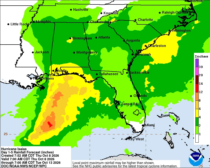
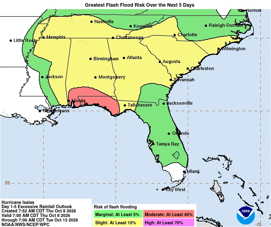
Isaias is forecast to produce 75–180 mm (3–7 inches) of rain from far southeastern Louisiana to Florida’s Big Bend region from Friday through the weekend. Localized totals approaching 380 mm (15 inches) are possible within persistent rainbands across the Florida Panhandle and Big Bend.
Considerable flash and urban flooding is possible across much of southern Alabama, the Florida Panhandle and southwestern Georgia. River flooding is also expected, some of which could be significant.
Isolated tornadoes will be possible Friday night across coastal Alabama, the Florida Panhandle and far southwestern Georgia. The tornado threat is forecast to continue Saturday across eastern Alabama, Georgia and northern Florida.
Damaging gusts are possible across much of central and northern Alabama and portions of western and northern Georgia, particularly over higher terrain. NHC said additional Tropical Storm and High Wind Watches or Warnings could be required.
Swells generated by Isaias were forecast to affect the western and northern Yucatán Peninsula before spreading north toward the U.S. Gulf Coast on Friday. The swells are likely to produce life-threatening surf and rip-current conditions.
References:
1 NHC Hurricane Isaias Public Advisory Number 8 – NOAA/NHC -October 8, 2026
2 NHC Hurricane Isaias Forecast Discussion Number 8 – NOAA/NHC – October 8, 2026
3 Hurricane Isaias Intermediate Advisory Number 8A – NOAA/NHC – October 8, 2026

Rishav Kothari is Editor-in-Chief of The Watchers, where he runs the newsroom and covers earthquakes, volcanoes, severe weather and space weather.
