
NOAA gives El Niño an 83% chance of reaching historic strength in late 2026
El Niño strengthened further across the equatorial Pacific in September 2026, and NOAA’s Climate Prediction Center (CPC) said on October 8 that the October–December Relative Oceanic Niño Index (RONI) has an 83% chance of reaching at least +2.5°C (+4.5°F)—a level that would exceed previous El Niño events in its record dating to 1950. The World Meteorological Organization (WMO) separately forecast a Niño-3.4 anomaly of approximately +3.7°C (+6.7°F) for the same period.
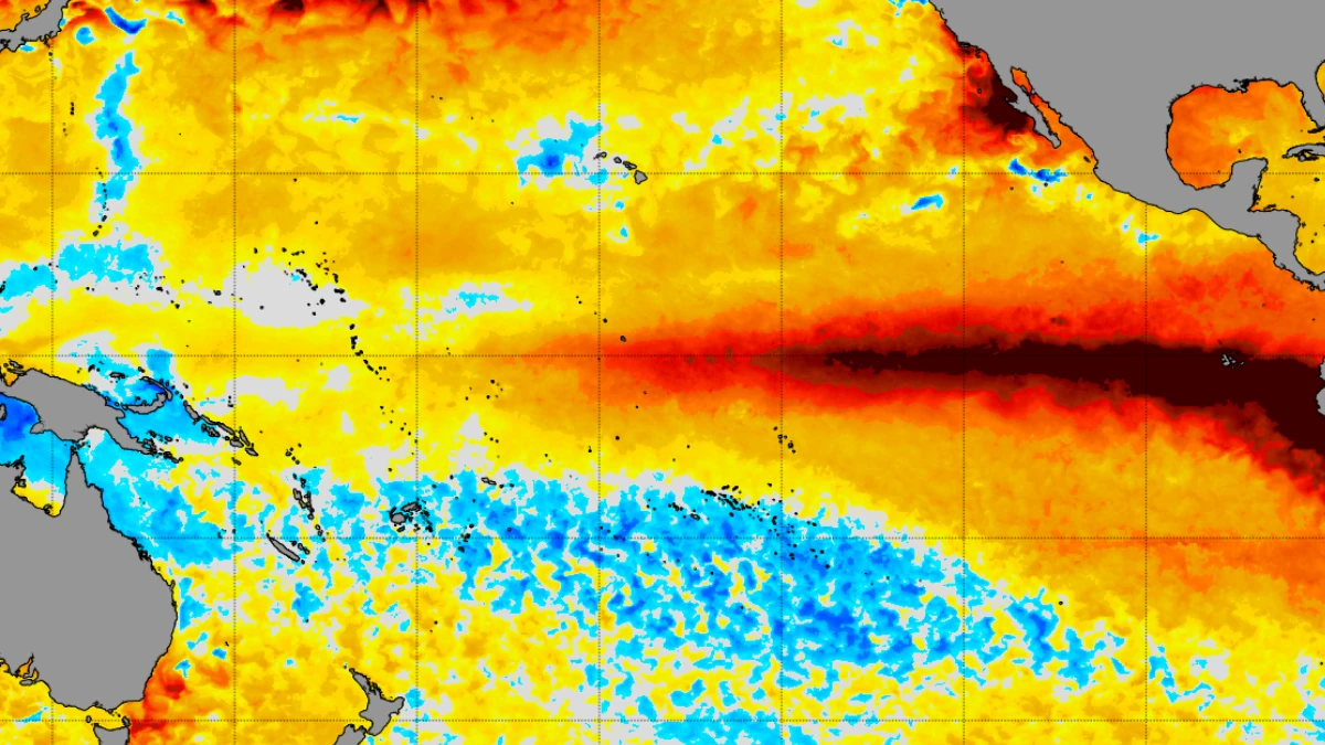
NOAA Coral Reef Watch 5 km sst anomalies for October 7, 2026. Image credit: NOAA
CPC maintained an El Niño Advisory after oceanic and atmospheric observations showed further strengthening during September. The agency said strong-to-very strong conditions were likely through January–March 2027, with the probability remaining above 83%.
Sea-surface temperature anomalies exceeded +4°C (+7.2°F) in portions of the eastern equatorial Pacific during September. CPC’s relative Niño indices increased to +2.1°C (+3.8°F) in Niño-3.4, +3°C (+5.4°F) in Niño-3 and +3.9°C (+7°F) in Niño-1+2.
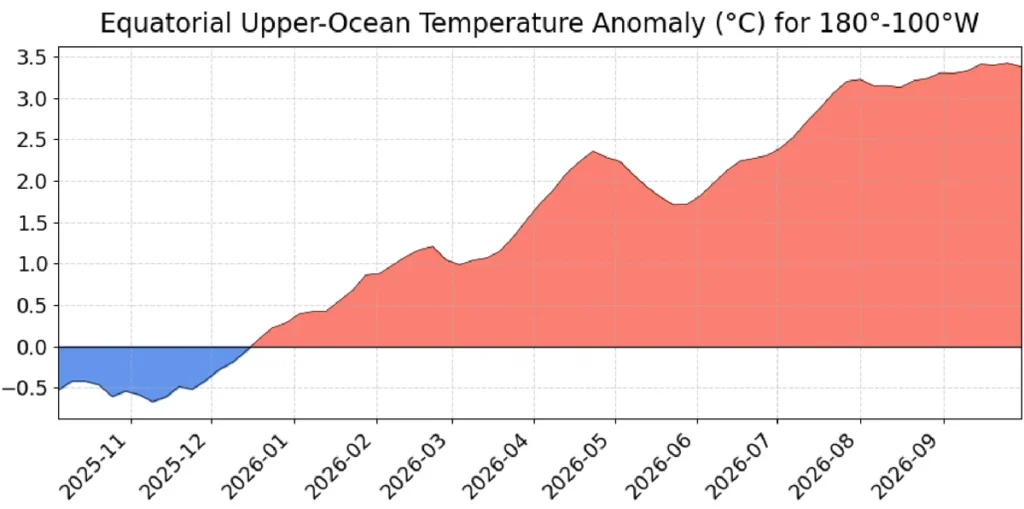
Warmth also remained pronounced below the ocean surface. CPC said the equatorial subsurface temperature index across 180°–100°W was well above average, with a deeper-than-average thermocline and temperature anomalies exceeding +10°C (+18°F) at depth in the eastern Pacific.
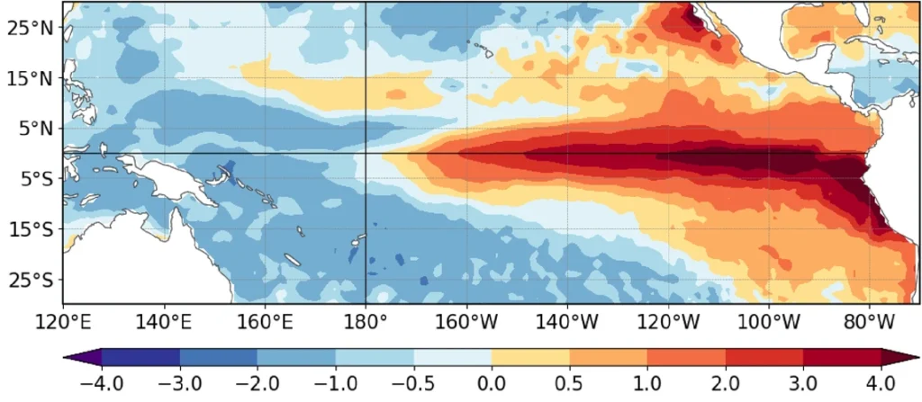
Atmospheric conditions were coupled with the ocean warming. Low-level westerly wind anomalies and upper-level easterly wind anomalies extended from the western to east-central equatorial Pacific, while enhanced convection and rainfall persisted over the central and eastern Pacific and convection remained suppressed over Indonesia.
Traditional and equatorial Southern Oscillation indices were significantly negative. CPC said the combined oceanic and atmospheric conditions reflected a strengthening El Niño.
CPC assigned probabilities of 54% for September–November, 83% for October–December and 70% for November–January that the three-month RONI would reach at least +2.5°C (+4.5°F).
The agency said that threshold would exceed the strength of previous El Niño events in its record dating to 1950. The +2.5°C threshold is higher than CPC’s general “very strong” category, which begins at a three-month RONI of +2°C (+3.6°F).
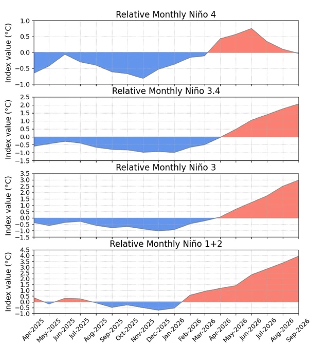
WMO issued a separate seasonal assessment on October 8 forecasting further intensification toward the end of the year. Its multi-model ensemble placed the October–December Niño-3.4 sea-surface temperature anomaly at approximately +3.7°C (+6.7°F), with the warming trend forecast to peak around December.
If realized, WMO said the +3.7°C anomaly would be the highest since observations began, exceeding the previous stated maximum of +2.6°C (+4.7°F) during November 2015–January 2016.
WMO also reported a near-100% probability that El Niño would persist through February 2027. The assessment represents a forecast consensus involving 13 national and international climate centers.
The CPC and WMO values are not directly interchangeable. WMO’s Niño-3.4 anomaly is calculated relative to a 1993–2009 baseline, while CPC’s RONI uses a 1991–2020 baseline, subtracts the tropical-mean SST anomaly and applies a variance adjustment before calculating the three-month average.
WMO said other ocean basins would also influence the October–December climate pattern. A positive Indian Ocean Dipole was forecast to peak in October and then weaken, producing a seasonal anomaly of approximately +0.5°C (+0.9°F), while equatorial Atlantic sea-surface temperatures were expected to remain above normal.
The strongest wet seasonal signal was forecast across the central and eastern equatorial Pacific east of the International Date Line. Above-normal rainfall was also favored across the Greater Horn of Africa, parts of Central Asia and coastal East Asia, northern parts of the Arabian Peninsula, parts of North America south of 45°N and southeastern South America.
Drier-than-normal conditions were favored over the Indian subcontinent, southern Central America, parts of the Caribbean and northwestern South America. Broad dry signals were also forecast across the western Pacific and equatorial Atlantic.
These outlooks describe regions where particular three-month rainfall categories have increased probabilities. They do not predict that every location will experience the expected conditions or establish the timing and severity of individual floods, droughts, storms or heat events.
CPC similarly cautioned that a stronger El Niño increases the probability of conditions commonly associated with the phenomenon but does not guarantee particular impacts. Local hazard outcomes require separate forecasts from the responsible national and regional meteorological agencies.
References:
1 El Niño/Southern Oscillation (ENSO) Diagnostic Discussion – NOAA/CPC – October 8, 2026

Rishav Kothari is Editor-in-Chief of The Watchers, where he runs the newsroom and covers earthquakes, volcanoes, severe weather and space weather.
Published in the last 24 hours
- CPC posts a slight risk of heavy rain from the Gulf Coast to the Northeast urban corridor November 25-29, and a moderate risk of West Coast wind and Sierra snow on November 25
- Florida's east coast faces a moderate flash flood risk Wednesday through Friday, with 4 to 8 inches of rain forecast and the St. Johns River near Cocoa already in major flood at 17.13 feet
- Cyclone Akvan to make landfall between Nellore and Visakhapatnam around noon on November 20, IMD forecasts 120-130 km/h winds gusting to 145
- Radio pulses every 7.9 minutes reveal binary with white dwarf and Sun-like star Epicenter
