• Winds high above the Arctic broke a 68-year record by collapsing in early November, and while the eastern US has already had a taste of the cold it shook loose, forecasters say a second wave could arrive around Thanksgiving weekend

    About 20 miles above the North Pole, a vast ring of wind normally spins faster and faster as winter approaches. This November, it did the opposite. Around November 10, the winds slowed, stopped and then reversed direction. It’s the earliest event of its kind since reliable records began in 1958. Now forecasters are watching to…

  • A ring of wind spinning about 19 miles above the Arctic, far higher than any passenger jet flies, has started breaking apart weeks earlier than ever recorded, and forecasters say the cold it was holding in place could spill into the US and Europe within weeks

    Every winter, a vast ring of wind forms high above the North Pole. It circles the Arctic about 19 miles up, roughly three times higher than a passenger jet cruises, and it helps keep the coldest air of the season locked over the far north. This November, that ring has faltered. Its winds slowed almost…

  • A patch of warm Pacific water that could become the strongest El Niño in more than 70 years sits thousands of miles from any American town, yet it is already the main reason NOAA expects a wetter winter across the South and a milder one across the North

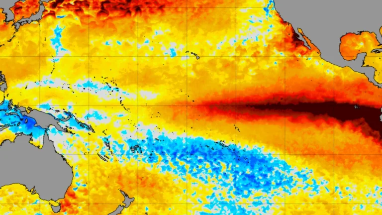
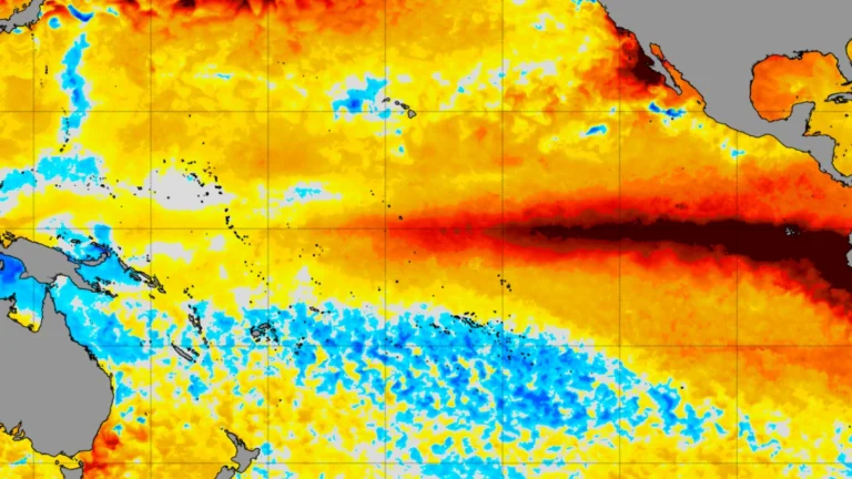
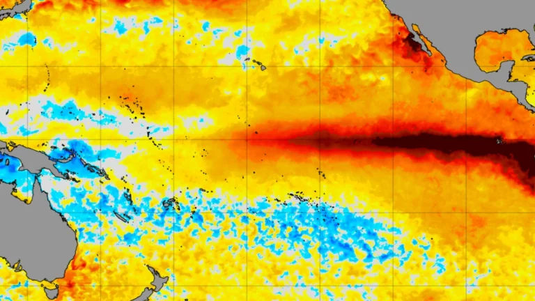
    Far out in the tropical Pacific, along the equator, the ocean surface is running unusually hot. Across a band of water thousands of miles long, temperatures are well above normal, in some areas by more than 4°F. Nobody in Texas, Florida or Minnesota can see it or feel it. Yet according to NOAA, this distant…

  • Polar vortex winds at 60°N drop from 22.13 to 5.44 m/s in eight days in rare November disruption; major SSW remains forecast

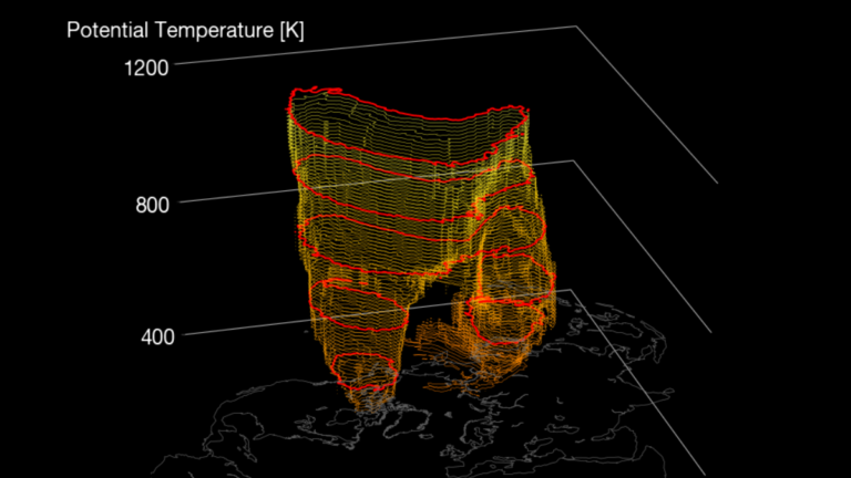
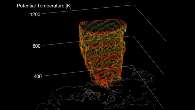
    A rare November disruption of the Northern Hemisphere stratospheric polar vortex is underway, with the daily-mean wind at 60°N and 10 hPa weakening from 22.13 m/s (49.5 mph) on October 25 to 5.44 m/s (12.2 mph) on November 2. Forecast guidance continues to indicate a possible brief reversal during the second week of November, which would meet the defining wind-reversal threshold used to identify a major sudden stratospheric warming, while any surface-weather response remains uncertain.

  • Arctic stratospheric polar vortex forecast to weaken sharply in early November

    NASA Ozone Watch’s current Arctic wind product forecasts the 60°N zonal-mean wind at 10 hPa falling from 22.12 m/s (49.5 mph) on October 25, 2026, to 4.15 m/s (9.3 mph) by November 3, compared with a climatological mean of 25.97 m/s (58.1 mph) for November 3. A few European forecast models go further and reverse the winds, but said that outcome remains unlikely and Canadian surface impacts are not established.

  • Very strong El Niño favors wetter South and warmer North in NOAA’s 2026–27 winter outlook, U.S.

    A strengthening El Niño is shifting the odds toward wetter-than-average conditions across the southern United States and East Coast during winter 2026–27, according to NOAA. The Climate Prediction Center (CPC) reported that the latest weekly Niño-3.4 sea-surface temperature anomaly had reached +2.4°C (+4.3°F), while warmer-than-average conditions are favored across much of the northern United States.

  • NOAA gives El Niño an 83% chance of reaching historic strength in late 2026

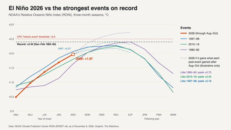
    El Niño strengthened further across the equatorial Pacific in September 2026, and NOAA’s Climate Prediction Center (CPC) said on October 8 that the October–December Relative Oceanic Niño Index (RONI) has an 83% chance of reaching at least +2.5°C (+4.5°F)—a level that would exceed previous El Niño events in its record dating to 1950. The World Meteorological Organization (WMO) separately forecast a Niño-3.4 anomaly of approximately +3.7°C (+6.7°F) for the same period.

  • El Niño heat could cause 451 000 additional deaths worldwide by February 2027 as Pacific temperatures reach record levels

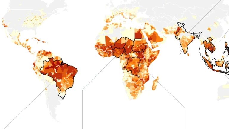
    A new Climate Impact Lab assessment estimates that heat associated with El Niño could contribute to 451 000 additional deaths worldwide from June 2026 through February 2027, including 239 000 ± 11 000 during September 2026–February 2027. The September 23 report comes as NOAA measurements show central Pacific sea-surface temperatures reaching levels last seen during the 2015–16 El Niño, while multiple media reports indicate a new daily temperature-anomaly record.

  • California declares statewide emergency as very strong El Niño develops ahead of 2026-27 winter

    California Governor Gavin Newsom proclaimed a statewide emergency on September 21, 2026, to accelerate preparations for potential flooding, landslides, coastal hazards and other winter impacts as a strengthening El Niño develops in the tropical Pacific. NOAA said there is a greater than 90% chance the event will become very strong during Northern Hemisphere autumn and winter 2026–27.