
Very strong El Niño favors wetter South and warmer North in NOAA’s 2026–27 winter outlook, U.S.
A strengthening El Niño is shifting the odds toward wetter-than-average conditions across the southern United States and East Coast during winter 2026–27, according to NOAA. The Climate Prediction Center (CPC) reported that the latest weekly Niño-3.4 sea-surface temperature anomaly had reached +2.4°C (+4.3°F), while warmer-than-average conditions are favored across much of the northern United States.
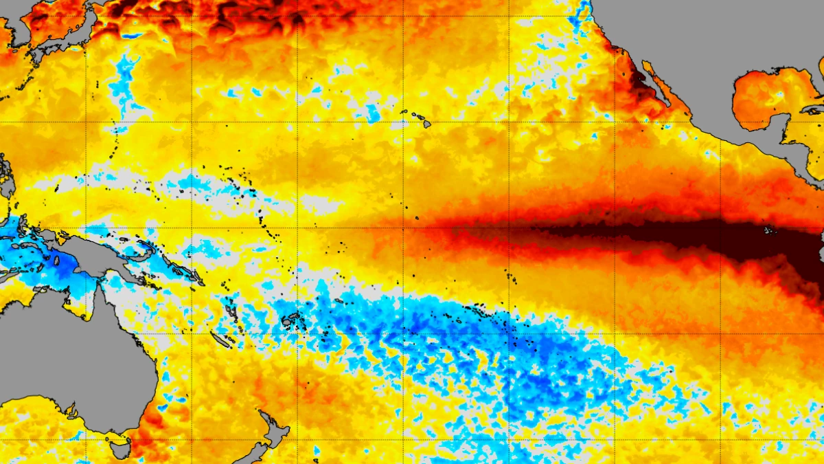
Image credit: NOAA
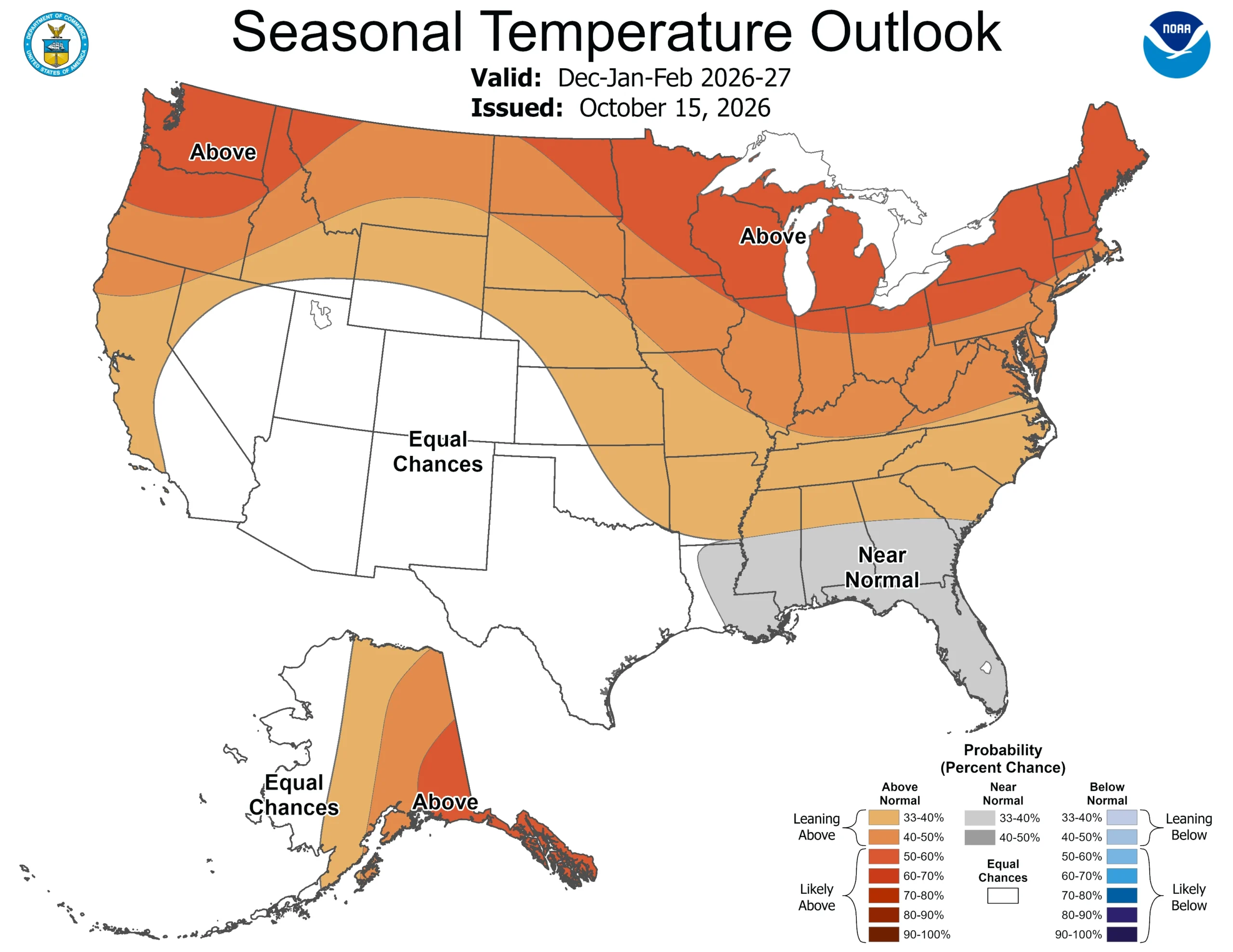
The National Oceanic and Atmospheric Administration (NOAA) favors warmer-than-average temperatures across much of the northern United States and wetter-than-average conditions from California to Florida and along the East Coast during December 2026–February 2027, according to its U.S. Winter Outlook released on October 15. Drought is forecast to improve or end across the Southwest, Southern Great Plains, Southeast and parts of the East Coast.
Warmer-than-average conditions are favored by NOAA’s temperature outlook across northern California, the Pacific Northwest, the Midwest, the Mississippi Valley, much of the East, and Alaska, as well as Puerto Rico and the U.S. Virgin Islands.
Near-normal seasonal temperatures are most likely across parts of the Southeast, including Florida, while Hawaii and much of the Southwest have equal chances of below-, near-, or above-average seasonal temperatures.
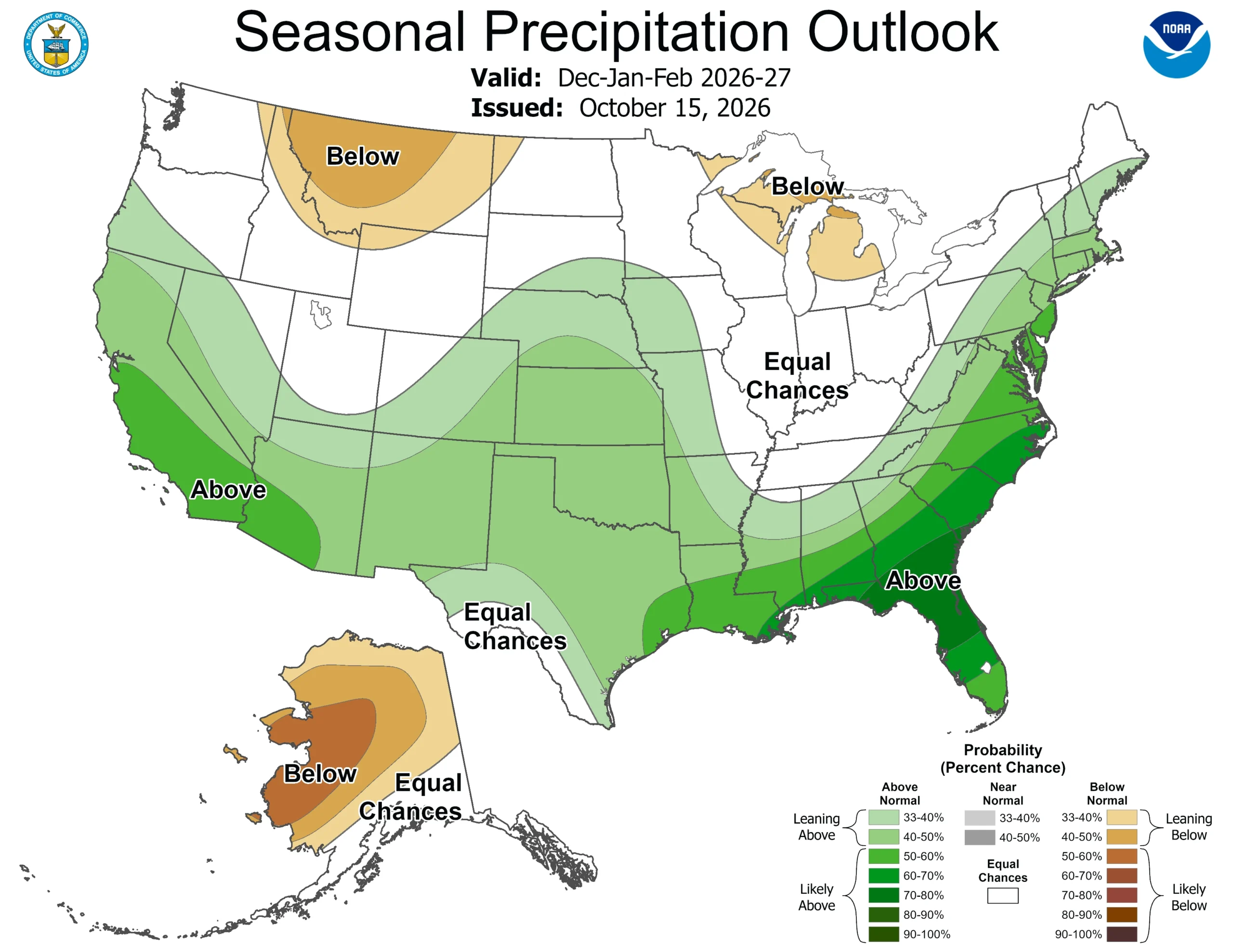
The precipitation outlook favors wetter-than-average conditions from the Southwest through the southern tier and Southeast and northward along the East Coast. The Climate Prediction Center (CPC) places probabilities for above-normal precipitation above 70% in some areas of the extreme Southeast and northern Florida through the January–March 2027 season.
Drier-than-average conditions are favored across parts of the northern Rockies and Great Lakes and much of western and central interior Alaska.
The Intermountain West, northern Plains, Ohio Valley, Puerto Rico, and the U.S. Virgin Islands include areas assigned equal chances among the three precipitation categories.
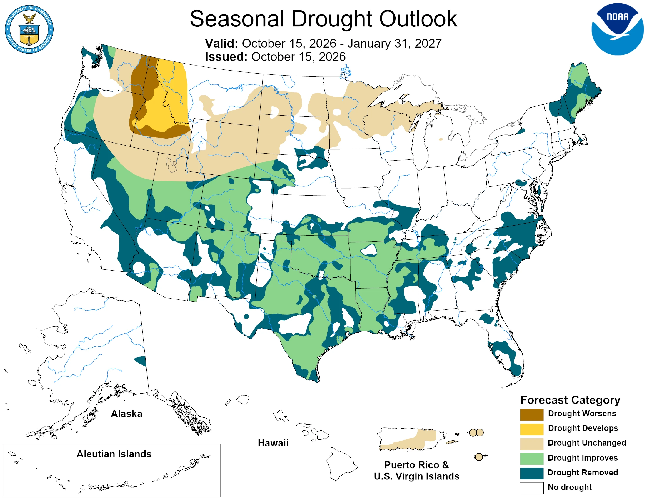
NOAA’s drought outlook for October 15 through January 2027 favors improvement or removal of drought across the Southwest, Southern Great Plains, Southeast and parts of the East Coast.
Drought development or worsening is favored across sections of the northern Rockies and in northeastern Oregon and eastern Washington.
CPC said the ongoing El Niño remains in a strengthening phase and is exerting a major influence on the winter and spring seasonal outlooks. Its October 15 assessment placed the latest weekly Niño-3.4 sea-surface temperature anomaly at +2.4°C (+4.3°F), Niño-3 at +3.4°C (+6.1°F) and Niño-1+2 at +4.4°C (+7.9°F).
Sea-surface temperatures were more than 2°C (3.6°F) above average across a broad section of the eastern equatorial Pacific, with anomalies reaching 4°C (7.2°F) in some areas nearer South America.
CPC maintained an El Niño Advisory in its October 8 ENSO Diagnostic Discussion and assigned an 83% probability that the October–December three-month Relative Oceanic Niño Index, or RONI, will reach at least +2.5°C (+4.5°F). CPC said a value at or above that threshold would exceed previous El Niño events in its record dating to 1950.
The agency stressed that stronger El Niño conditions increase the probability of characteristic regional impacts but do not guarantee a particular outcome at any location.
The National Weather Service expects a very strong El Niño to favor a southward and eastward displacement of the Pacific jet stream across the contiguous United States. NWS Director Ken Graham said the pattern tilts the odds toward stormier weather across the South.
NOAA said increased precipitation can provide drought relief. Where heavy precipitation occurs, however, dry soils can increase the risk of flash flooding and mudslides.
CPC based the seasonal outlook on the ongoing El Niño event together with North American Multi-Model Ensemble and Copernicus ensemble guidance, statistical and hybrid forecast tools, long-term temperature and precipitation trends and other climate drivers.
Statistical, hybrid and dynamical guidance is consistent in favoring above-normal temperatures across much of the northern United States, while temperature guidance has a larger spread across the Southwest and parts of the southern Plains. CPC describes Southeast wetness as one of the most reliable El Niño signals, while guidance shows a wider range of possible precipitation outcomes across the West Coast and Southwest.
Seasonal outlook categories describe the probability of temperature and precipitation falling above, near, or below climatological averages rather than the weather expected on individual days.
CPC advises using observations and shorter-range forecasts once the valid period begins. NOAA scheduled the next seasonal outlook update for November 19, 2026.
NOAA also introduced winter-weather product changes for the 2026–27 season. The NWS Probabilistic Precipitation Portal is operational, providing low-end, expected, and high-end amounts for snow, ice, and rain together with threshold probabilities.
The NWS implemented the capability to use “Particularly Dangerous Situation” wording in selected Blizzard Warnings and Ice Storm Warnings when forecasters have high confidence that an event will pose an exceptional threat and reach extreme or historic severity.
References:
1 El Niño looms large over U.S. Winter Outlook – NOAA – October 15, 2026
2 Prognostic Discussion for Long-Lead Seasonal Outlooks – NOAA/CPC – October 15, 2026

Rishav Kothari is Editor-in-Chief of The Watchers, where he runs the newsroom and covers earthquakes, volcanoes, severe weather and space weather.
