
Multiple wildfires prompt evacuations during the first Santa Ana event of the season in Southern California
Multiple wildfires broke out across Southern California on October 15, 2026, prompting evacuation orders and road closures during the season’s first moderate-to-strong Santa Ana wind event. The Henderson Fire at Camp Pendleton reached 568 ha (1 404 acres), while the Los Angeles County Fire Department (LACoFD) listed the Bryson Fire near Malibu at approximately 41 ha (102 acres) with 0% containment in its evening update.
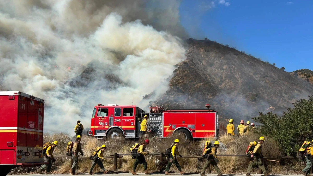
Smoke rising from the Bryson Fire in LA County, California on October 15, 2026. Credit: LACoFD
The Henderson Fire began at 14:35 LT (21:35 UTC) near Henderson Street and Brown Street at Marine Corps Base Camp Pendleton in San Diego County. Camp Pendleton Fire Department had jurisdiction, and CAL FIRE reported that the fire reached 568 ha (1 404 acres) by 20:14 LT (03:14 UTC on October 16).
The fire threatened structures and overhead power lines, and four airtankers were assigned during the initial response.
Authorities ordered the Las Flores, or 41 Area, to evacuate and temporarily closed Interstate 5 in both directions between Harbor Drive and Basilone Road; reopening began at 17:49 LT (00:49 UTC on October 16), and the evacuation order was lifted at 19:31 LT (02:31 UTC on October 16).

The Bryson Fire was burning near Encinal Canyon Road and Mulholland Highway north of Malibu. LACoFD listed the fire at approximately 41 ha (102 acres) with 0% containment in its October 15 evening major-incident update; an archived CAL FIRE incident entry timestamped 20:42 LT (03:42 UTC on October 16) carried the same figures and identified LACoFD as the administering agency.
Other official relay pages carried different preliminary acreage and containment values later in the evening. Because LACoFD was the agency having jurisdiction, this report uses its direct 41 ha (102 acres), 0%-contained update and treats the figures as provisional.
Los Angeles County listed evacuation orders for zones KAN-U017 and SYC-U016-A. Evacuation warnings covered surrounding areas, including western Malibu, while Agoura High School was designated as a human shelter and Agoura Animal Care Center and Pierce College Equestrian Center were designated for evacuated animals.
County officials also evacuated youths from Campus Vernon Kilpatrick to Barry J. Nidorf Juvenile Hall and Secure Youth Treatment Facility in Sylmar. Road closures included Decker Road at Encinal Canyon Road, Kanan Road at Mulholland Highway, and Mulholland Highway at Westlake Boulevard.
The City of Malibu said Pacific Coast Highway remained open in both directions as of 22:30 LT on October 15 (05:30 UTC on October 16). A Southern California Edison Public Safety Power Shutoff affected parts of central and western Malibu, and Malibu City Hall was scheduled to remain closed on October 16.

The Peak Fire north of San Gabriel Canyon Road and Mirador Drive near Azusa was mapped at 17.4 ha (43 acres) and 41% contained by 19:43 LT (02:43 UTC on October 16). The fire was under unified command involving LACoFD and the U.S. Forest Service’s Angeles National Forest.
An initial evacuation order for the Peak Fire was dropped at 15:08 LT (22:08 UTC), while the remaining evacuation warnings were lifted at 19:05 LT (02:05 UTC on October 16) and downgraded to an advisory. Northbound traffic on San Gabriel Canyon Road had been closed at Sierra Madre during the response.
In an Area Forecast Discussion issued at 01:24 LT (08:24 UTC) on October 16, the National Weather Service (NWS) Los Angeles/Oxnard office said peak gusts had reached 97–129 km/h (60–80 mph) on October 15, with the strongest winds in the mountains of Ventura and Los Angeles counties.
NWS forecast further strengthening into Friday morning, with gusts potentially reaching 145 km/h (90 mph) in mountain areas and 97 km/h (60 mph) in the Los Angeles valleys and the valleys and coastal areas of Ventura County.

A Red Flag Warning remained in effect for most valleys and coastal areas of Los Angeles and Ventura counties through 20:00 LT on October 17 (03:00 UTC on October 18). NWS forecast northeast to east winds of 32–56 km/h (20–35 mph), gusts of 64–89 km/h (40–55 mph), isolated gusts near 105 km/h (65 mph), and minimum relative humidity of 8–15%, creating conditions favorable for rapid fire growth and extreme fire behavior if new ignitions occur.
California activated its State Operations Center on October 15 after placing it in an enhanced-readiness posture one day earlier. CAL FIRE and the California Governor’s Office of Emergency Services prepositioned firefighters, engines, aircraft and specialized equipment in Los Angeles, Ventura, Orange and Santa Barbara counties for deployment from October 15 through October 18.
Official incident records listed the causes of the Henderson, Bryson and Peak fires as under investigation. Acreage, containment, and evacuation information remained preliminary and may change as mapping and suppression operations continue.
References:
1 Henderson Fire – CAL FIRE – updated October 15, 2026
2 Bryson Fire update – CAL FIRE – October 15, 2026
3 Bryson Fire evacuation warning – City of Westlake Village – October 15, 2026

Rishav Kothari is Editor-in-Chief of The Watchers, where he runs the newsroom and covers earthquakes, volcanoes, severe weather and space weather.
