
Amazon fire hotspots rise 82.6% in October 2026 as El Niño intensifies
A strengthening El Niño is helping dry the Amazon as fires escape into standing forest during the 2026 fire season. Over a much longer period, researchers have also documented increasing damage from storm winds. Understanding both threats requires separating the drought conditions that allow fires to spread from the thunderstorms that can bring trees down.

Smoke rises from wildfire WE024 which has prompted a pre-evacuation notice in Flin Flon, Manitoba, Canada May 27, 2025. Credit: Manitoba Government (used representationally)
Satellite analysis has identified 23 998 fire hotspots in October 2026, an 82.6% increase from last year, as El Niño strengthened and rainfall fell below average across much of the basin. Storm-driven forest damage adds a separate threat, documented over decades and projected to increase under continued warming.
Dry conditions extended across much of the basin. A regional bulletin published on November 13 found that 29 of the Amazon’s 32 sub-basins had below-average October rainfall across more than half their area.
Pacific warming shifts the rainfall pattern
NOAA’s November 12 assessment said El Niño continued to strengthen. It put the chance of reaching a historical-strength threshold at about 60% for both October–December 2026 and November 2026–January 2027.
That threshold is a three-month Relative Oceanic Niño Index (RONI) of at least +2.5°C (+4.5°F). The latest observed August–October RONI reading was +2.0°C (+3.6°F), with recent values still subject to revision.
RONI measures Pacific warming relative to the wider tropical ocean, rather than using the local temperature anomaly alone. “Super El Niño” is an informal description; the World Meteorological Organization uses weak, moderate, strong and very strong in its operational classification.
The Amazon connection runs through the Walker circulation, a large-scale pattern of rising and sinking tropical air. During El Niño, the Pacific’s main region of rising air and heavy rainfall shifts eastward. Associated sinking air over parts of the Amazon can suppress deep cloud development and rainfall.
A 2024 study of the Amazon’s 2023 drought identified this El Niño-related downward motion over the northern basin, alongside other regional and ocean influences. Brazil’s federal assessment on November 11, 2026, favored below-average rainfall across much of the North through January 2027.

Fires escape into standing forest
In its October 15 assessment, NASA described fires used to manage pastures and fields escaping into drought-dried forest. Douglas Morton, an Earth system scientist at NASA’s Goddard Space Flight Center, said forests damaged by earlier fires were burning again.
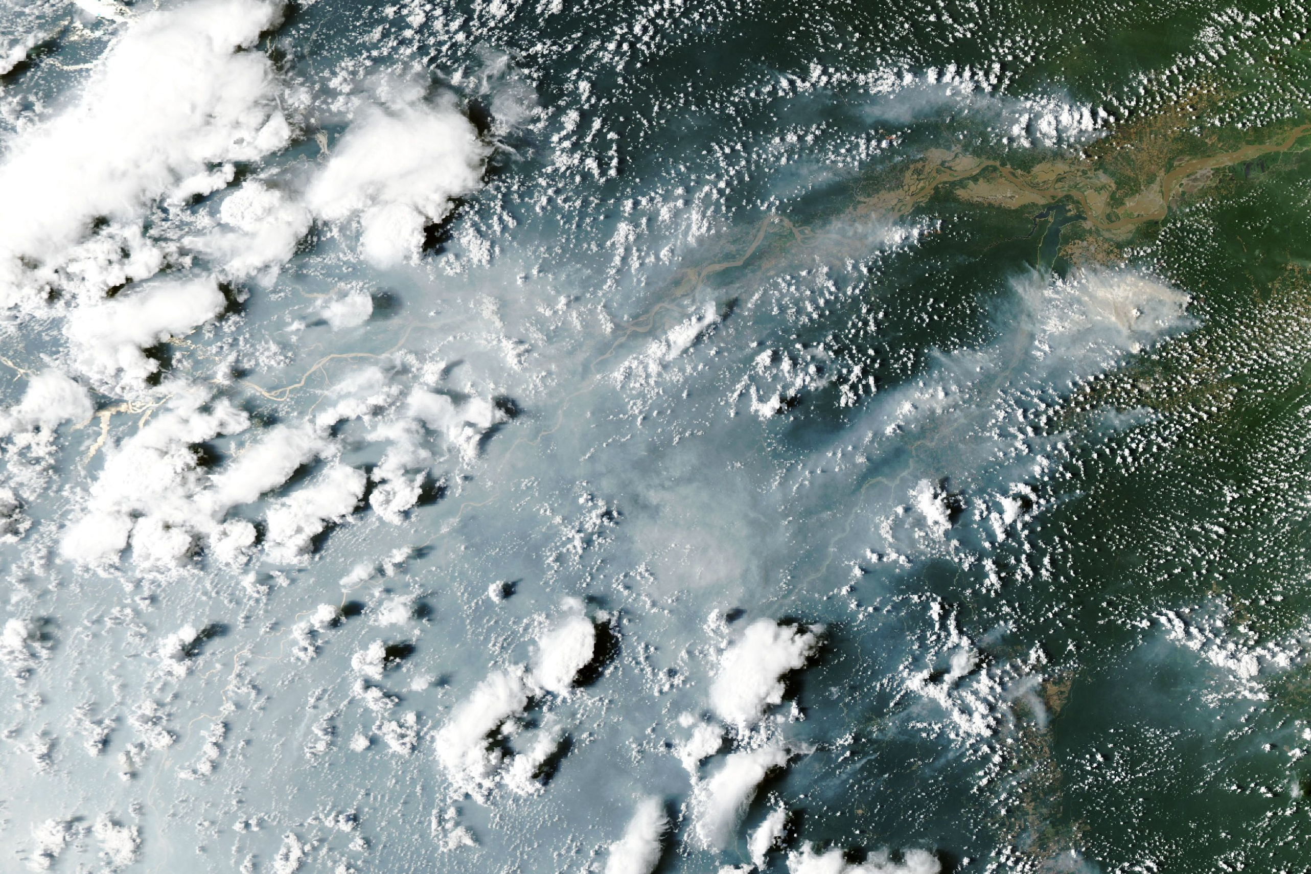
The regional October count covers satellite detections across the Amazon Basin, including several land-cover types. A hotspot is a detected heat signal: it is not necessarily a separate fire, a measure of fire intensity or an area burned. One continuing fire can generate multiple detections.
Less clearing does not mean less fire damage
Brazil’s PRODES monitoring estimated 3 335 km² (1 288 square miles) of deforestation in the Legal Amazon between August 2025 and July 2026. That was down 41.8% from the preceding year and the lowest annual estimate in the series, which began in 1988.
Those figures do not cover October’s fires: the PRODES reporting year had ended on July 31. They also measure a different process. Fire can degrade standing forest without immediately producing the complete canopy removal recorded as deforestation.
The fall in clearing therefore does not, by itself, identify the cause of the later fire increase. Ignitions, rainfall deficits, fuel conditions and land use all matter. Assessing their contributions requires observations covering comparable places and periods.
Storm winds leave a separate record
Powerful thunderstorms can drive air downward and outward across the forest, breaking trunks and uprooting trees. The resulting patches of damaged forest are known as windthrows, or blowdowns.
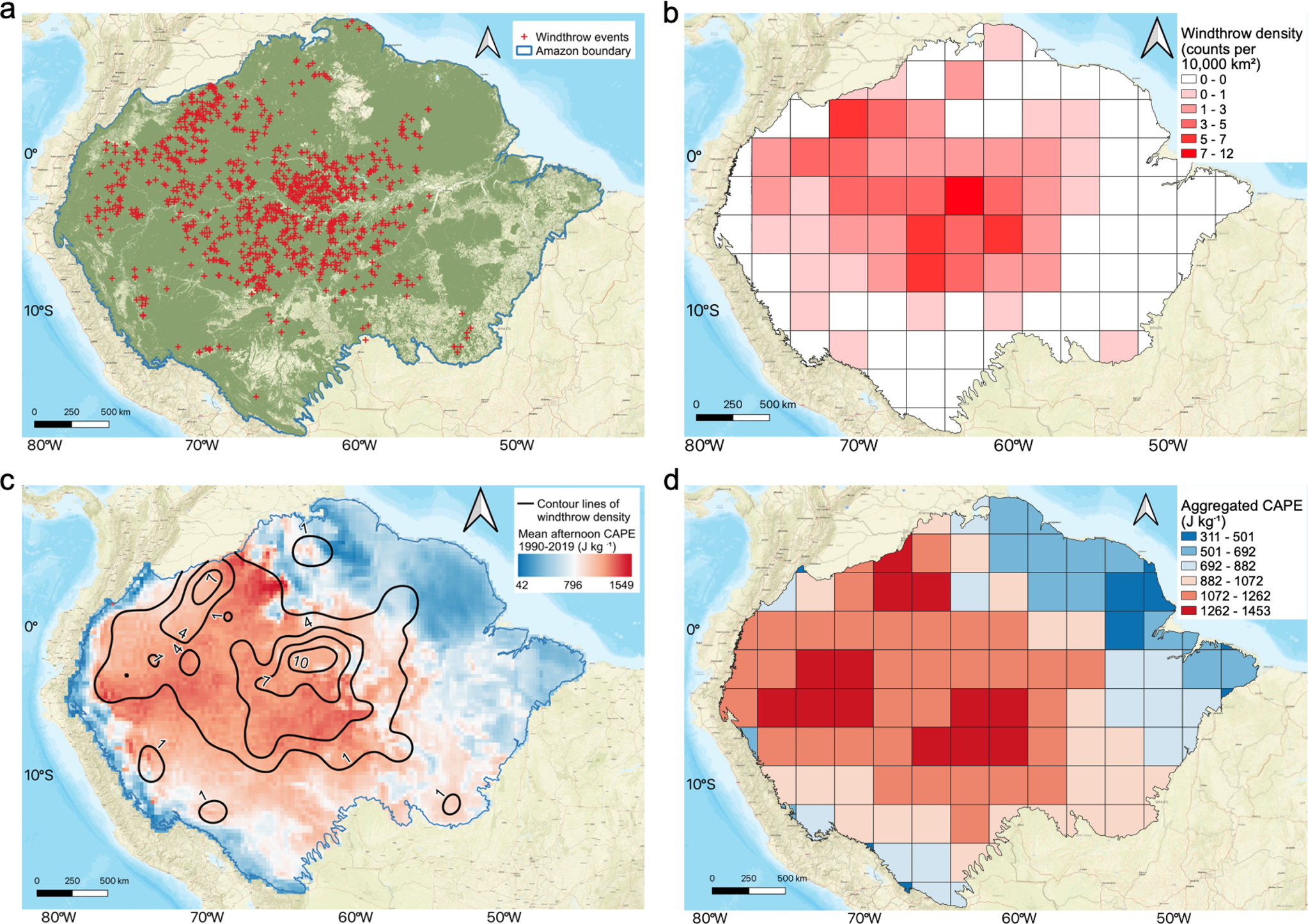
A 2024 study in AGU Advances identified 3 179 large windthrows in 33 survey years between 1985 and 2020. Each mapped event covered at least 30 hectares (74 acres). Both the annual number of events and the estimated affected area increased significantly over the record.
The disturbances were unevenly distributed, with clusters in the central and western Amazon. About one-third of the mapped events occurred within roughly 3% of the surveyed basin.
The authors found no significant relationship between annual windthrow number or area and the Oceanic Niño Index, a measure of El Niño and La Niña conditions. Although the trend was consistent with changing atmospheric conditions, the study did not establish a more specific cause. Its observations do not support treating the current El Niño as a basin-wide storm warning.
What the late-century projections show
The 2023 study in Nature Communications connected the spatial pattern of windthrows with convective available potential energy, or CAPE. This describes the energy available to rising air and helps characterize an environment favorable to strong convection; it is not a direct count of thunderstorms.
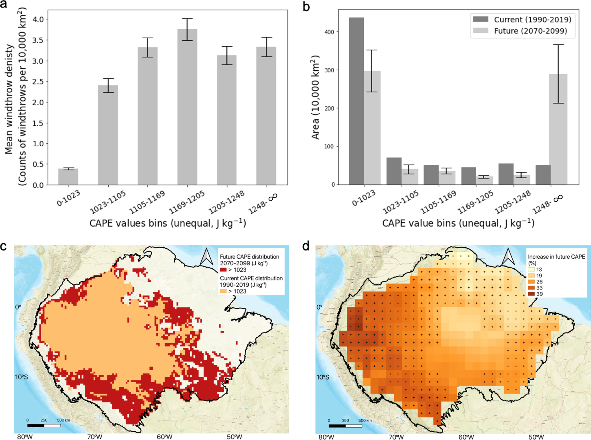
Using that relationship and climate-model projections, the researchers estimated a 51 ± 20% increase in the area favorable to extreme storms and a 43 ± 17% increase in windthrow density under the high-emissions SSP5-8.5 scenario. The future period was 2070–2099. The reported uncertainty describes the spread across the models used.
These are conditional projections of future storm environments and forest disturbance. They are neither measurements of change during the 2026 fire season nor predictions of how many storms this El Niño will produce.
Some damage stays out of view
Smoke, clouds and canopy cover can hide fires from satellite detection. Shane Coffield, a University of Maryland researcher working at NASA Goddard, described that limitation in NASA’s October report.
“On some of the smokiest days, we have very few detections from MODIS and VIIRS, and we know that isn’t right.”
The windthrow inventory has its own limits: it tracks large, visible patches, leaving smaller disturbances outside its ≥30-hectare (74-acre) threshold. Cloud cover can also delay identification, so the year a scar appears in the record may differ from the year of the storm.
Fire detection, burned-area mapping and repeat surveys of forest damage answer different questions. Reading them together helps distinguish where the forest is burning now, where storms have brought trees down, and which changes remain projections.
References
1 Amazon Cooperation Treaty Organization / Amazon Regional Observatory. 2026. Amazon Environmental Monitoring Bulletin, No. 4. November 2026; observations for October 2026.
2 NOAA Climate Prediction Center. 2026. El Niño/Southern Oscillation Diagnostic Discussion. Issued November 12, 2026.
3 NOAA Climate Prediction Center. Relative Oceanic Niño Index: data and methodology. Accessed November 15, 2026; recent values are provisional.
4 World Meteorological Organization. 2026. El Niño is forecast to intensify. Operational classification and terminology.
5 Brazil, Secretariat for Social Communication. 2026. Governo Federal intensifica monitoramento e faz balanço de ações em resposta ao El Niño. November 11, 2026.
6 Espinoza, J.-C., et al. 2024. The new record of drought and warmth in the Amazon in 2023 related to regional and global climatic features. Scientific Reports, 14, 8107.
7 NASA Earth Observatory. 2026. Fires Arrive in the Amazon Rainforest. October 15, 2026.
8 Brazil, Secretariat for Social Communication. 2026. Brasil alcança menores taxas de desmatamento da série histórica na Amazônia e no Cerrado. October 22, 2026; updated October 26, 2026. PRODES estimates for August 2025–July 2026.
9 Urquiza-Muñoz, J. D., et al. 2024. Increased Occurrence of Large-Scale Windthrows Across the Amazon Basin. AGU Advances, 5, e2023AV001030.
10 Feng, Y., Negrón-Juárez, R. I., Romps, D. M., and Chambers, J. Q. 2023. Amazon windthrow disturbances are likely to increase with storm frequency under global warming. Nature Communications, 14, 101. Open author-hosted paper.
11 Max Planck Institute for Biogeochemistry. 2024. Windthrow events in the Amazon increased since 1985. November 27, 2024.
12 Biron, L. / Berkeley Lab. 2023. Climate Change Likely to Uproot More Amazon Trees. UC Berkeley Research, January 17, 2023.

The Watchers Staff covers earthquakes, volcanoes, severe weather, space weather and other natural events. Published since 2011, The Watchers reports on a changing planet and the science behind it.
Published in the last 24 hours
- In 1943, a flight instructor in Texas flew a two-seat training plane into the eye of a hurricane because he was curious, then landed and took the base weatherman up for a second pass Epicenter
- In 2013 a landslide fell onto Svínafellsjökull in southeast Iceland, leaving thicker ice at the foot of the slope; that ice is now moving away and the mountainside has shifted 1 to 3 cm. Epicenter
- Kīlauea's north vent threw lava about 660 feet (200 m) high for six hours on 5 November 2026; the summit is now reinflating, with the next episode forecast for 16 to 21 November. Epicenter
- In 2005, a driver near Russia's Chulyshman River picked up a stone to wedge under his car wheel and kept it for 20 years; the Meteoritical Bulletin has now approved it as the Altai Republic's first meteorite. Epicenter
