
A new model of Antarctica’s Thwaites Glacier that lets seawater seep beneath its grounded ice projects up to about 30 millimeters of sea-level rise by 2100 from that glacier alone, roughly twice the earlier average projection, in a scenario its authors call a lower bound
A new observation-calibrated model of Antarctica’s Thwaites Glacier projects 30.1 ± 5.7 mm of global mean sea-level rise by 2100 in a 5 ± 1 km grounding-zone scenario that allows ocean water to melt ice beneath the grounded edge of the glacier. The result is about twice the 15.2 ± 21.8 mm mean of the earlier ISMIP6 ensemble even though the simulations hold climate forcing at 1996–2023 averages, a setup the authors use as a lower-bound baseline rather than a most-likely forecast.
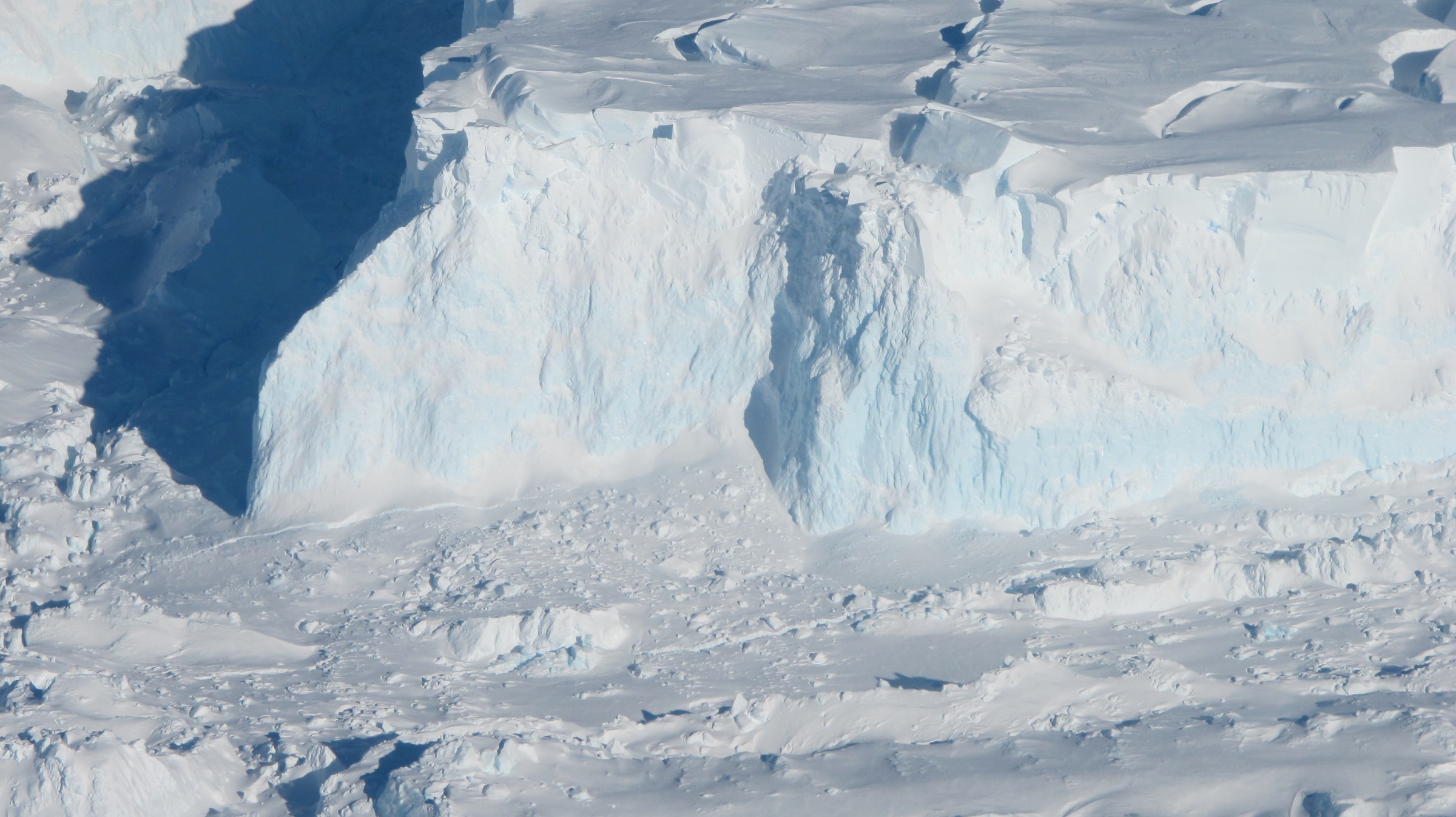
A close look at the shelf (8093672443). Credit: NASA ICE (public domain), via Wikimedia Commons.
The 30.1 mm figure is not a single forecast for Thwaites Glacier. Under the same model configuration and a representative submarine melt rate of 110 m per year, simulations without an actively melting grounding zone produce 8.3 ± 3.0 mm of sea-level contribution by 2100. A 1 ± 1 km grounding zone produces 14.3 ± 3.1 mm, while a 3 ± 1 km zone produces 19.4 ± 5.2 mm. The larger 5 ± 1 km case produces 30.1 ± 5.7 mm.
Poinelli et al. (2026), published in Nature Communications on October 12, examined a physical process that most large-scale ice-sheet models do not explicitly represent. At the grounding zone, where ice resting on the seafloor approaches the point where it becomes afloat, pressurized seawater can move inland beneath grounded ice, repeatedly lifting it with the tides and exposing its underside to ocean-driven melting.

The observational basis for that change in the model came from satellite radar measurements reported by Rignot et al. in 2024. Daily-repeat ICEYE synthetic-aperture radar observations collected from March to June 2023 documented a tidally controlled grounding zone about 6 km wide in the central part of Thwaites’ main trunk and about 2 km wide along its steeper flanks.
The same observations detected irregular seawater intrusions another 6 km upstream during high tide. The intruding layer was estimated at about 5–10 cm thick. Radar measurements showed the grounded ice moving vertically as seawater entered and left the subglacial system, providing evidence that the transition from grounded to floating ice extends across kilometers rather than behaving as a single fixed line.
The distinction changes where melting can occur in an ice-sheet model. A conventional grounding-line treatment places a relatively abrupt boundary between grounded and floating ice. In the new simulations, basal melting can continue upstream of the flotation line across a prescribed grounding-zone distance, decreasing from its maximum value at the grounding line to zero at the inland limit of the intrusion.
The researchers implemented that process in the Ice-sheet and Sea-level System Model (ISSM) and tested 105 combinations of submarine melt rate and grounding-zone length. They initialized the glacier to conditions representative of the 1990s and evaluated the hindcast against independently derived records of grounding-line migration, ice discharge, thickness change and ice-flow acceleration.
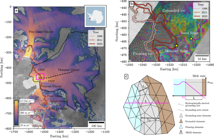
The largest observed retreat since 1996 has occurred along the western, fastest-flowing Thwaites Main Trunk. Its grounding line has moved inland by about 25 km at an average rate of roughly 800 m per year. The main trunk currently remains pinned on Mouginot Ridge, a seafloor high several kilometers across and roughly 950 m below sea level.
High-resolution ICEYE observations have recorded temporary ungrounding as much as 10 km inland of Mouginot Ridge. The eastern sector, beneath the Thwaites Eastern Ice Shelf, has retreated more slowly and less uniformly, at about 400–700 m per year since 1996, corresponding to roughly 10–20 km.
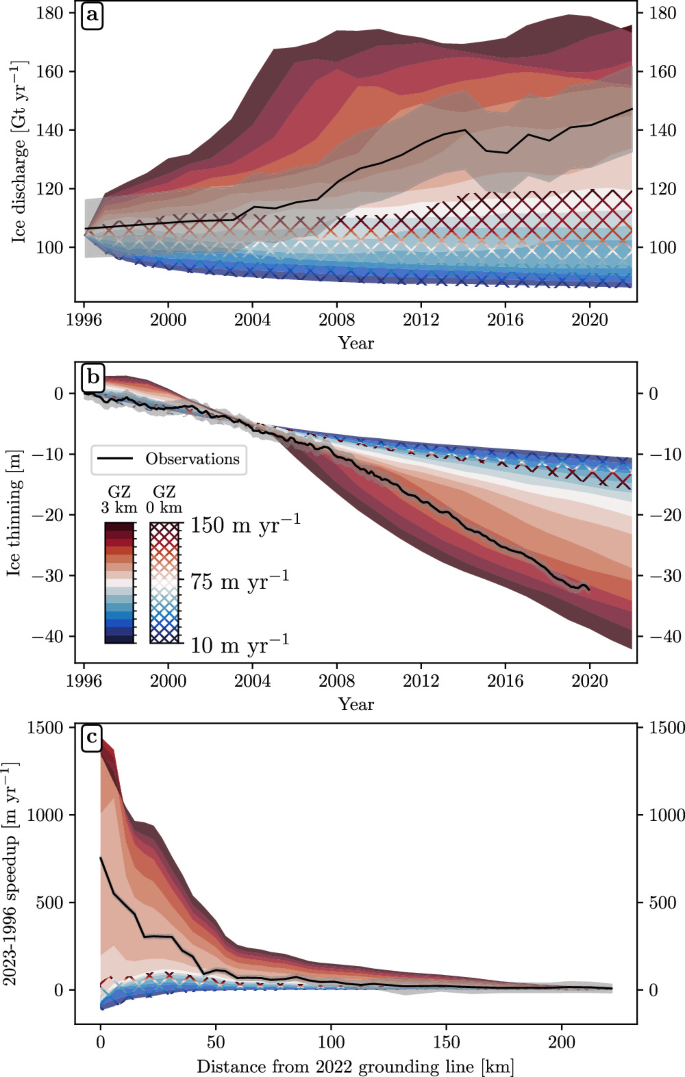
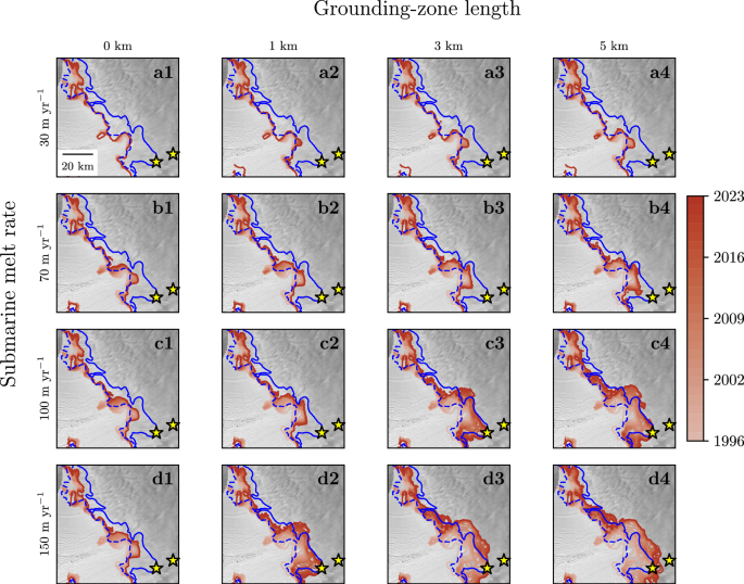
A model without an actively melting grounding zone can reproduce some early changes, but it requires submarine melt rates near 150 m per year and still underestimates later discharge, thinning, acceleration and grounding-line retreat. A 1 km grounding zone can reproduce the concurrent retreat of the main trunk and eastern sector, but again requires a melt rate of about 150 m per year.
With a 3 km grounding zone, the simulations reproduce the concurrent retreat of both sectors at a submarine melt rate of about 120 m per year and also capture the associated discharge. Melt rates of about 100–120 m per year produce modeled thinning close to the observed spatial average of 32 m of grounded-ice thinning over the historical simulation.
A Bayesian calibration using all of the historical constraints does not identify one unique combination of melt and intrusion distance. Instead, it concentrates the best-fitting parameter combinations around grounding zones 2–5 km wide and melt rates of about 90–120 m per year. Simulations without a grounding zone are four times less likely to reproduce the historical trends than simulations with a grounding zone several kilometers wide.
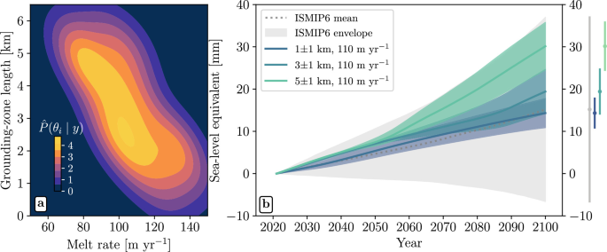
The differences become larger when the calibrated model is extended to 2100. With the representative 110 m-per-year melt rate, a simulation without a grounding zone contributes 8.3 ± 3.0 mm to global mean sea level. A 1 ± 1 km grounding zone produces 14.3 ± 3.1 mm, comparable with the ISMIP6 ensemble mean of 15.2 ± 21.8 mm.
A 3 ± 1 km grounding zone, centered on the maximum of the Bayesian posterior distribution, produces 19.4 ± 5.2 mm by 2100. A 5 ± 1 km grounding zone, consistent with the kilometer-scale intrusion distances documented by recent radar observations, produces 30.1 ± 5.7 mm. The latter is approximately twice the ISMIP6 ensemble mean under the corresponding constant-forcing comparison.
The ISMIP6 comparison itself is highly uncertain. Its 15.2 mm mean carries an uncertainty of ±21.8 mm, and some members of that multi-model ensemble produce a late-century slowdown in ice discharge. The comparison therefore shows how far the new 5 km experiment sits above the earlier ensemble mean; it does not mean that every previous model projected half as much sea-level rise.
The authors describe the future simulations as a lower-bound forcing scenario because climate conditions are held at averages from 1996–2023 rather than being progressively warmed through the end of the century. The term does not make 30.1 mm a guaranteed minimum, nor does it identify the 5 km case as the most likely future outcome. It describes the climate forcing used to isolate the effect of grounding-zone melting.
The researchers separately tested moderate additional ocean warming. A temperature increase of 0.5–0.7°C relative to the modeled conditions would, under the study’s simplified linear melt relationship, add about 10 m per year to basal melting and increase projected ice loss by about 15%. Across the tested experiments, each additional kilometer of grounding-zone length changed projected sea-level equivalent by an average of about 22%.
That sensitivity comparison applies to the model configuration tested in the study. Ocean circulation and heat transport inside an evolving ice-shelf cavity are not resolved directly, and the simulations do not include a possible future shoaling of the thermocline, which would expose more of the ice-shelf base to relatively warm modified Circumpolar Deep Water.
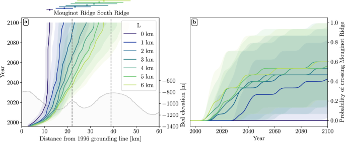
Mouginot Ridge provides the next control on the model’s future behavior. Simulations without a grounding zone, or with a 1 km zone, remain pinned there through 2100 regardless of the tested melt rate. With grounding zones 2–3 km wide, the model gives about a 45% probability of crossing the ridge before the end of the century.
The 2 km simulations cross Mouginot Ridge on average around 2088, while the 3 km simulations do so around 2065. Grounding-zone widths of 4–6 km raise the probability of crossing the ridge by 2100 to about 60%. In the 5–6 km cases, the earliest modeled unpinning occurs in 2038.
The 2038 date is not a predicted collapse of Thwaites Glacier. It is the earliest modeled detachment from Mouginot Ridge within the wider-intrusion experiments. After that detachment, the modeled grounding line retreats across predominantly retrograde seafloor, where the bed deepens inland, toward the next major topographic obstacle identified as South Ridge.

The projections remain dependent on simplifying assumptions. Grounding-zone length is fixed within each simulation even though real intrusion distances vary with bed and surface slopes, tidal amplitude, height above flotation and subglacial water pressure. The authors therefore treat each prescribed distance as an effective, time-averaged intrusion scale.
The model also keeps the ice front fixed. It does not simulate calving-front retreat or the ungrounding of pinning points near the front of the Thwaites Eastern Ice Shelf and main trunk, both of which can alter ice-shelf buttressing. The basal friction coefficient remains constant through time, and the model does not explicitly represent changes in friction caused by seawater lubrication or an evolving subglacial hydrology network.
Ocean-induced melting is represented with a depth-dependent parameterization instead of a fully coupled ice-ocean circulation model. The prescribed melt rates are consistent with satellite-derived estimates and high-resolution ocean simulations, but the approach does not resolve the changing circulation and heat transport inside the cavity as the glacier retreats.
Bathymetry adds another source of uncertainty. During initialization, the researchers raised the modeled seafloor locally by as much as 100 m beneath floating ice where the BedMachine reconstruction relies on gravity inversion. The adjustment was required to make the modeled 1996 grounding line consistent with observations, and the authors report that it remains within the uncertainty of the gravity-derived bathymetry.

Thwaites itself contains an ice volume equivalent to about 65 cm of global mean sea-level rise, but the new study does not project the complete loss of that ice by 2100. Its result is much narrower: representing kilometer-scale seawater intrusion beneath the grounded edge changes the model’s ability to reproduce the glacier’s recent history and raises its modeled sea-level contribution during this century.

Reducing the remaining uncertainty will require better observations beneath the ice as well as more complete models. Poinelli et al. identify in-situ measurements of temperature, salinity and circulation beneath the ice shelf as important constraints, together with future model development that allows grounding-zone extent, subglacial hydrology, basal friction and the evolving ocean cavity to interact rather than remain prescribed independently.
The central result is therefore not that Thwaites has a fixed 30 mm future contribution. It is that a physical process observed beneath the glacier changes both the hindcast and the projection when it is represented explicitly. The width and evolution of that grounding zone now become quantities that future observations and coupled ice-ocean models need to constrain if projections of Thwaites’ contribution to sea-level rise are to narrow.
References:
1 Poinelli, M., Rignot, E., Seroussi, H., Cuzzone, J., Pelle, T., & Larour, E. (2026). Sea-level contribution from Thwaites Glacier doubles in an observation-constrained ice-sheet model. Nature Communications, 17, 10364. DOI: 10.1038/s41467-026-77976-1
2 Rignot, E., Ciracì, E., Scheuchl, B., Tolpekin, V., Wollersheim, M., & Dow, C. (2024). Widespread seawater intrusions beneath the grounded ice of Thwaites Glacier, West Antarctica. Proceedings of the National Academy of Sciences, 121(22), e2404766121. DOI: 10.1073/pnas.2404766121
3 Poinelli, M., Rignot, E., Seroussi, H., Cuzzone, J., Pelle, T., & Larour, E. (2026). Supplementary Data and Code from: Sea-level contribution from Thwaites Glacier doubles in an observation-constrained ice-sheet model. Zenodo. DOI: 10.5281/zenodo.16551126

I’m a science journalist and researcher at The Watchers, contributing to the Epicenter edition, where I cover peer-reviewed scientific research and emerging discoveries across Earth and space sciences. With a background in astronomy and a passion for environmental science, I’ve worked in shark and coral conservation in Fiji, conducting reef and shark-behavior research, contributing to mangrove restoration, and earning PADI Open Water and Coral Reef Certifications. I bring a blend of scientific rigor and storytelling to illuminate the discoveries shaping our planet and beyond.
Published in the last 24 hours
- Marine iguanas in the Galápagos got shorter by as much as 6.8 cm (2.7 inches), or a fifth of their length, when El Niño left them short of the seaweed they can digest, and the biggest ones shrank the most and lived the longest Epicenter
- An 83-year-old lodge owner named Harry R. Truman refused to leave his home on Spirit Lake below Mount St. Helens in the spring of 1980, insisting the mountain would not get him, and the May 18 eruption buried him along with his 16 cats Epicenter
- In 2017, El Niño rains turned part of Peru's Sechura Desert into a lake more than four times the size of Lake Tahoe, and families went out on wooden rafts to fish it Epicenter
- Green Lake, Hawaii's largest freshwater lake, was gone by the afternoon of June 2, 2018, after lava from Kilauea filled its basin. The water was about 20 feet deep, not the 200 feet often claimed. Epicenter
