
In 2017, El Niño rains turned part of Peru’s Sechura Desert into a lake more than four times the size of Lake Tahoe, and families went out on wooden rafts to fish it
In April 2017, a temporary lake in Peru’s Sechura Desert expanded to 2 172 km² (839 square miles), more than four times the surface area of Lake Tahoe. Satellite observations captured the transformation as exceptional coastal El Niño rains sent floodwater into a low-lying desert basin, creating an immense aquatic landscape that local communities have repeatedly used for fishing.
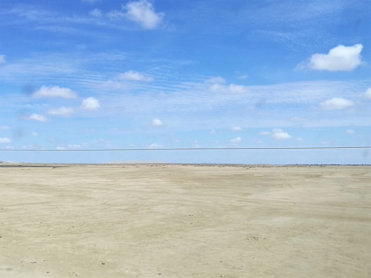
The enormous body of water was known as La Niña, a temporary lagoon system in the Piura region of northwestern Peru. It forms during exceptional rainy periods when swollen rivers overflow into the surrounding desert. Unlike a permanent lake, its boundaries can expand rapidly during flooding and contract as water levels fall.
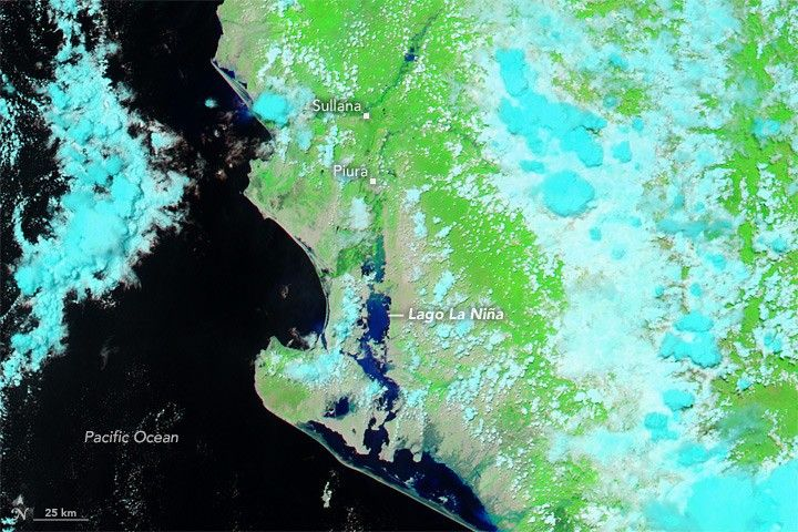
The transformation was visible from space. A NASA Aqua satellite image acquired on March 23, 2017, showed floodwater spreading across normally arid terrain, including areas that had appeared largely dry in an image from March 2016. The extent of La Niña would continue increasing until early April, when satellite measurements placed it among the largest documented expansions of the lagoon.
Why a desert can become an enormous lake
The Sechura Desert lies along Peru’s normally dry northern coast. Rainfall varies sharply between ordinary years and exceptional El Niño periods, when unusually warm conditions in the nearby Pacific can contribute to intense precipitation and overflowing rivers.
The 2017 episode was a coastal El Niño, known locally as El Niño costero. It was distinct from the major basin-wide El Niño events of 1982–83 and 1997–98. Although the mechanisms and geographical extent differed, all three episodes produced severe rainfall and flooding along Peru’s northern coast.
In the Sechura region, rising flows in the Piura, Cascal and Motupe river systems help supply the temporary lagoon. Water spreads through existing low-lying wetlands and lagoons before extending toward the Bayóvar depression, where the surrounding topography allows large volumes to accumulate.
La Niña is therefore better understood as a changing network of flooded lowlands than as a single permanent lake with fixed shorelines. During the 2017 event, the inundated area extended southward from the Ramón and Ñapique lagoons into the Bayóvar depression. Researchers described part of that flooded depression as approximately 100 km (62 miles) long and 18 km (11 miles) wide, with maximum water depths of around 10 m (33 feet).
The basin’s physical shape explains why so much water can collect in a desert. The exceptional river flows explain why it does so only intermittently.
From scattered pools to 2 172 km2 (898 miles2)
The lagoon began forming on January 27, 2017, when satellite images revealed small bodies of water around the Ramón and Ñapique lagoons. During the first two weeks of February, the northern lagoons filled and floodwater began advancing farther south. By February 7, the estimated flooded area had reached 595 km² (230 square miles).
Rainfall intensified through March. Data from Peru’s National Water Authority, cited in the lagoon study, showed that the Piura River reached a discharge of approximately 3 468 m³/s (122 500 feet3/s) at the Puente Sánchez Cerro station on March 28. The high flows caused overbank flooding and erosion in the river’s middle and lower basin.
On April 5, the lagoon reached its maximum estimated surface area of 2 172 km² (898 miles2). Lake Tahoe, on the California–Nevada border, has a surface area of about 495 km² (191 square miles), according to the University of California, Davis. By surface area, the temporary Sechura lagoon was approximately 4.4 times as large.
Researchers estimated that La Niña held approximately 5.18 billion m³ of water at its maximum extent. That is a modeled volume derived from satellite observations and terrain elevation data, rather than a direct measurement of every part of the lagoon.
The expansion eventually reversed. By November 4, the lagoon’s surface had decreased to approximately 1 432 km² (553 square miles), a reduction of 34.1% from its April maximum. Even after several months of contraction, the remaining flooded area was substantially larger than Lake Tahoe.
Earlier episodes showed how temporary this landscape could be. Research cited by the Peruvian Marine Research Institute documented the drying of lagoon expansions associated with 1984 and 1998 through evaporation and seepage over periods of approximately 13 months. That historical duration should not be treated as an independently established drying date for the 2017 lake.
How scientists measured the lake from space
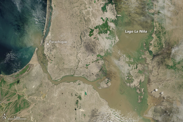
Credit: NASA Earth Observatory image by Jesse Allen, using Landsat data from the U.S. Geological Survey.
The principal measurements came from a study by Luis Escudero Herrera and Han Xu of the Instituto del Mar del Perú (IMARPE), published in 2019. The researchers analyzed 44 images from NASA’s Moderate Resolution Imaging Spectroradiometer (MODIS) aboard the Aqua satellite, selecting observations across January to November 2017.
The images had a spatial resolution of 500 m (1 640 feet), meaning each image pixel represented an area approximately 500 m across. The researchers used the Normalized Difference Vegetation Index (NDVI), a calculation based on how surfaces reflect different wavelengths of light, to distinguish water-covered areas from surrounding land.
They then estimated water volume using the ASTER Global Digital Elevation Model, a terrain dataset with 30 m (98-foot) spatial resolution. By comparing the mapped water area with estimated elevation differences, the researchers calculated how much water the flooded landscape could contain.
This method provided repeated measurements of an extensive and changing flooded area without requiring researchers to survey every shoreline. Its limitation is that the boundaries and volumes remain estimates. The figures should not be interpreted as exact water-level measurements at every location.
NASA’s independent satellite imagery documented the same broad transformation during March 2017, showing La Niña and the Piura River greatly expanded compared with the preceding year. Those images establish the visible flooding; the more precise peak-area estimate comes from the IMARPE analysis.
When the water arrives, fishing returns to the desert
For communities living around La Niña, the lagoon’s appearance changes more than the landscape. Its temporary waters can support fishing where that activity is impossible during dry periods, providing a source of food and income for households that otherwise depend on agriculture, livestock and other work.
Research conducted through the University of St Andrews and Peruvian partners documented how fishing families use small wooden rafts and gillnets, locally called tamila nets. According to the project’s published accounts, fishing groups sometimes spend one or two weeks at the lagoon, establishing camps along its shores or on exposed dune islands. Family members also participate in preparing and handling the catch.
These accounts provide direct evidence for the wooden-raft tradition. They describe fishing practices across recurring lagoon episodes rather than establish the actions of particular families on a specified day in 2017.
The principal commercially important fish include flathead gray mullet, known locally as lisa (Mugil cephalus), and tilapia (Oreochromis species). A research report examining how Sechura communities responded to El Niño documented fishing alongside changes in agriculture and livestock activity, showing that the return of water can alter several sources of household income.
Official records confirm that lagoon fishing continued to attract regulatory attention after 2017. In May 2018, Piura’s regional production authority issued a permit for members of the Santo Domingo fishermen’s association to harvest mullet and tilapia from small rafts in La Niña. In September 2023, Peru’s Ministry of Production authorized a separate 20-day exploratory mullet fishery, subject to possible extension and scientific assessment.
The water’s arrival creates the conditions for fishing, but the available studies do not establish the exact origin of every fish population in each newly flooded area. Connections with rivers and other water bodies offer possible routes for colonization; identifying which routes supplied particular species would require more specific ecological evidence.
The same rains brought severe destruction
The benefits of temporary fishing cannot be separated from the wider consequences of the 2017 coastal El Niño. The extraordinary rainfall that filled the Sechura basin also flooded settlements, damaged roads and bridges, destroyed crops and interrupted economic activity across northern Peru.
During March 2017, The Watchers documented major flooding and rescue operations in northern Peru, followed by widespread emergency declarations as the situation deteriorated. The disaster also placed pressure on public health services and disrupted livelihoods far beyond the temporary lagoon.
A 2023 analysis published in PLOS ONE distinguished the 2017 coastal event from the major Pacific-wide El Niño episodes of earlier decades. It examined the damage to infrastructure, economic activity, and public health, identifying shortcomings in disaster preparedness and response. The intense coastal rainfall produced substantial consequences even without a conventional basin-wide El Niño of comparable strength.
For some desert communities, the resulting water made fishing and planting possible. For others, the same flooding caused losses that could not be offset by those opportunities. The different outcomes depend on where people live, what resources they can access, and how effectively they can respond to rapidly changing water conditions.
A recurring lake raises a long-term question
La Niña has expanded during multiple El Niño episodes, including 1982–83, 1997–98 and 2017. The estimated 1998 maximum of 2 326 km2 (898 miles2) was approximately 6.6% larger than the 2017 maximum. The newer event, however, was documented through repeated satellite observations that made its expansion and contraction unusually clear.
The lagoon remains important to regional planning. In September 2026, Peru’s Ministry of Production reported a technical assessment of fishing and aquaculture opportunities at La Niña. Officials identified mullet being harvested by local fishers and considered potential pilot activities involving tilapia and other species, conditional on further technical and sanitary evaluation.
That assessment was not proof that aquaculture could operate safely or economically under every future flood condition. The lagoon’s water supply, ecological conditions, and usable extent vary, making each episode a separate management challenge rather than a guaranteed source of production.
The 2017 record shows how quickly an exceptionally wet season can transform a desert basin and how gradually that transformation can reverse. Future monitoring could help determine when the lagoon becomes suitable for fishing, how its fish populations develop, and which measures protect communities and infrastructure as water spreads.
The central challenge is to anticipate both sides of the same physical process: the floodwater that threatens settlements can also create a temporary aquatic resource. Understanding when, where, and for how long that resource will exist is essential to making use of it without underestimating the hazards that brought it into being.
References:
1 Escudero Herrera, L., and Xu, H. (2019). Formación y evolución de la laguna La Niña en 2017, utilizando imágenes satelitales de MODIS-Aqua. Boletín del Instituto del Mar del Perú, 34(1), 105–114 – Instituto del Mar del Perú – 2019.
2 Tahoe Facts and Trivia – UC Davis Tahoe Environmental Research Center – Undated; accessed November 10, 2026.
3 Floodwaters Inundate Coastal Peru – NASA Earth Observatory – March 29, 2017.
4 Calle, O. El Niño Phenomenon: Stories from the Desert of Sechura and La Niña Lagoon – University of St Andrews, Farming and Fishing in the Desert – June 17, 2021.
5 The Impact of the El Niño Phenomenon on Fishing, Agricultural, and Livestock Activity in the Sechura Desert – University of St Andrews and research partners – 2022.
6 Resolución Directoral Regional N.° 00523-2018-DRP – Dirección Regional de la Producción de Piura – May 23, 2018.
7 Yglesias-González, M., et al. (2023). Reflections on the impact and response to the Peruvian 2017 Coastal El Niño event: Looking to the past to prepare for the future. PLOS ONE, 18(9), e0290767. DOI: 10.1371/journal.pone.0290767 – PLOS ONE – September 26, 2023.
8 Resolución Ministerial N.° 311-2023-PRODUCE – Ministerio de la Producción, Peru – September 12, 2023.
9 PRODUCE evalúa en visita técnica el potencial acuícola y pesquero de Laguna La Niña – Ministerio de la Producción, Red Nacional de Información Acuícola – September 22, 2026.

Rishav Kothari is Editor-in-Chief of The Watchers, where he runs the newsroom and covers earthquakes, volcanoes, severe weather and space weather.
Published in the last 24 hours
- Green Lake, Hawaii's largest freshwater lake, was gone by the afternoon of June 2, 2018, after lava from Kilauea filled its basin. The water was about 20 feet deep, not the 200 feet often claimed. Epicenter
- A South Dakota man put the widest and heaviest hailstone on US record in his freezer, and a power cut melted part of it before NOAA measured it at 8 inches across and nearly 2 pounds in 2010 Epicenter
- Black kites and brown falcons in northern Australia have been seen snatching smoldering sticks from wildfires, flying them into unburned grass and dropping them, starting new fires that send lizards, rodents and insects running straight toward the waiting birds Epicenter
- A levee protecting a highway north of San Francisco is pocked with animal burrows and only 3 feet wide in places, and a report warns this winter's El Niño could push water over the top Epicenter
