
A levee protecting a highway north of San Francisco is pocked with animal burrows and only 3 feet wide in places, and a report warns this winter’s El Niño could push water over the top
A UC Davis Road Ecology Center report identifies a levee east of the Petaluma River and north of Highway 37 as a high-probability, high-impact overtopping risk for winter 2026/27. The center measured parts of the levee in 2020 at about 0.9 m (3 feet) above mean higher high water; the 2026 report describes its crest as pocked with animal burrows and only about 0.9 m (3 feet) wide in many areas, while NOAA says a strong-to-very strong El Niño is likely through January–March 2027.
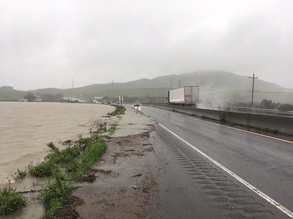
Tolay Creek Lagoon spills onto Highway 37 during flooding in the winter of 2016–2017. The image shows the corridor's established vulnerability to high water. Credit: Fraser Shilling / UC Davis
The vulnerable area lies immediately east of the Petaluma River, west of Lakeville Highway and north of Highway 37 in North San Francisco Bay. The Road Ecology Center says a combination of privately owned and state-owned levees along the river protects the area, and that failure of the levee east of the river would result in extensive flooding and at least temporarily close Highway 37.
The elevation measurement behind the warning was made in 2020. Researchers found parts of the levee about 0.9 m (3 feet) above mean higher high water (MHHW), a tidal datum based on the average of the higher daily high tides over a defined observation period. The 2026 report describes the levee crest as vegetated, unmaintained, pocked with animal burrows and only about 0.9 m (3 feet) wide in many areas.

The warning concerns overtopping risk, not a prediction that the levee will fail on a particular date. The report says additional coastal water associated with El Niño effects, combined with stormwater runoff moving down the Petaluma River, gives the levee a chance of water passing over its crest. It classifies the site as a “high-probability, high-impact” risk.
The report did not produce a new site-specific hydraulic simulation showing when the levee will overtop. Fraser Shilling, director of the Road Ecology Center and sole author of the special report, used existing coastal-flood and sea-level-rise mapping tools, including Climate Central’s Surging Seas system, to examine which areas become exposed at different water elevations. The Road Ecology Center’s 2020 field measurement of the levee and the mapped flood scenarios are separate pieces of evidence.
Earlier modeling systems cited in the report identified the area east of the Petaluma River as vulnerable under approximately 0.3 m (1 foot) and 0.6 m (2 feet) of sea-level-rise scenarios. Those figures are water-level thresholds used in vulnerability mapping; they are not forecasts that water beside Highway 37 will rise by exactly those amounts during a storm this winter.
The document is a single-author UC Davis Road Ecology Center special report rather than a journal research paper. It draws on the center’s previous Highway 37 work, the 2020 field measurement, earlier studies and publicly available coastal-risk mapping tools. The report itself does not state that it underwent peer review.
In a status presentation updated November 9, NOAA’s Climate Prediction Center lists an El Niño Advisory and says El Niño is present and continuing to strengthen. The agency’s current probabilistic outlook, issued October 8 and carried in the November 9 presentation, gives a greater than 83% chance of strong-to-very strong El Niño conditions continuing through January–March 2027.
The latest weekly sea-surface-temperature departure in the Niño-3.4 region is +2.3°C (+4.1°F), while NOAA’s Relative Oceanic Niño Index (RONI) reached +2.0°C for August–October 2026. The Watchers’ November 10 analysis places that value in its historical context. These basin-scale measurements describe the strength of El Niño; they do not predict whether a particular Northern California storm will overtop the Petaluma River levee.

California has already accelerated preparations ahead of the winter. Governor Gavin Newsom issued an El Niño preparedness emergency proclamation on September 21, directing state agencies to prioritize work intended to reduce flood and other storm-related risks.
A state filing posted on October 28 documents emergency levee work at Carneros River Ranch in Petaluma, at 3900 Highway 37. The San Francisco Bay Conservation and Development Commission authorized the continuation and completion of work to reinforce and raise approximately 427 m (1 400 feet) of existing levee because of anticipated very strong 2026 El Niño conditions. The filing says the emergency maintenance was authorized to prevent flooding of Highway 37.
The public filing does not identify the 427 m (1 400 feet) emergency-maintenance section as the specific levee segment measured by the Road Ecology Center in 2020. It gives the project location and purpose but does not cite the Road Ecology Center survey or otherwise establish that the two records concern the identical segment. They should therefore remain separate unless a primary source confirms the connection.
The age of the field measurement remains an important limitation. The 2026 report cites the Road Ecology Center’s 2020 elevation measurement but does not cite a newer field survey establishing how the measured crest elevation, animal burrows or maintenance condition have changed since then. A current engineering survey would be needed to establish the levee’s present geometry and condition independently of the report’s description.
The unresolved question is therefore not whether the location is vulnerable, but how the measured levee will perform if high coastal water, strong runoff and unfavorable storm conditions occur together during winter 2026/27. Neither NOAA nor the UC Davis report provides a date on which overtopping or levee failure is expected to occur.
References:
1 Coastal Flooding Risks for California: A Special Report for Winter 2026/27 – Road Ecology Center, University of California, Davis – October 2026
2 ENSO: Recent Evolution, Current Status and Predictions – NOAA Climate Prediction Center / NCEP – November 9, 2026
3 Carneros River Ranch Emergency Levee Maintenance – San Francisco Bay Conservation and Development Commission – October 28, 2026

I’m a science journalist and researcher at The Watchers, contributing to the Epicenter edition, where I cover peer-reviewed scientific research and emerging discoveries across Earth and space sciences. With a background in astronomy and a passion for environmental science, I’ve worked in shark and coral conservation in Fiji, conducting reef and shark-behavior research, contributing to mangrove restoration, and earning PADI Open Water and Coral Reef Certifications. I bring a blend of scientific rigor and storytelling to illuminate the discoveries shaping our planet and beyond.
Published in the last 24 hours
- Black kites and brown falcons in northern Australia have been seen snatching smoldering sticks from wildfires, flying them into unburned grass and dropping them, starting new fires that send lizards, rodents and insects running straight toward the waiting birds Epicenter
- In January 2000, chunks of ice weighing up to 6 pounds fell out of clear blue skies over Spain for 10 days. One smashed through a car windshield, and scientists still can’t fully explain where they came from Epicenter
- The fastest wind gust ever measured on Earth, 253 mph, hit an oil island off Australia during Cyclone Olivia in 1996, and nobody noticed for more than a decade, until experts reading old data quietly took the record from New Hampshire's Mount Washington Epicenter
- The people who pay closest attention to the weather are the ones storms have already cost the most, a study of 946 students found, with one damaging storm making little difference to how much attention a student paid, but two or more making a clear one Epicenter
