
In 1943, a flight instructor in Texas flew a two-seat training plane into the eye of a hurricane because he was curious, then landed and took the base weatherman up for a second pass
On July 27, 1943, Col. Joseph B. Duckworth deliberately flew a two-seat AT-6 Texan trainer into a hurricane crossing the upper Texas coast, broke through into its eye, landed at Bryan Field and went back into the storm with weather officer William Jones-Burdick. The U.S. Weather Bureau later described the first pass as the first known intentional flight through a hurricane center; archival research published eight decades later points to curiosity, not the famous story of a bet with British pilots, as the motive.
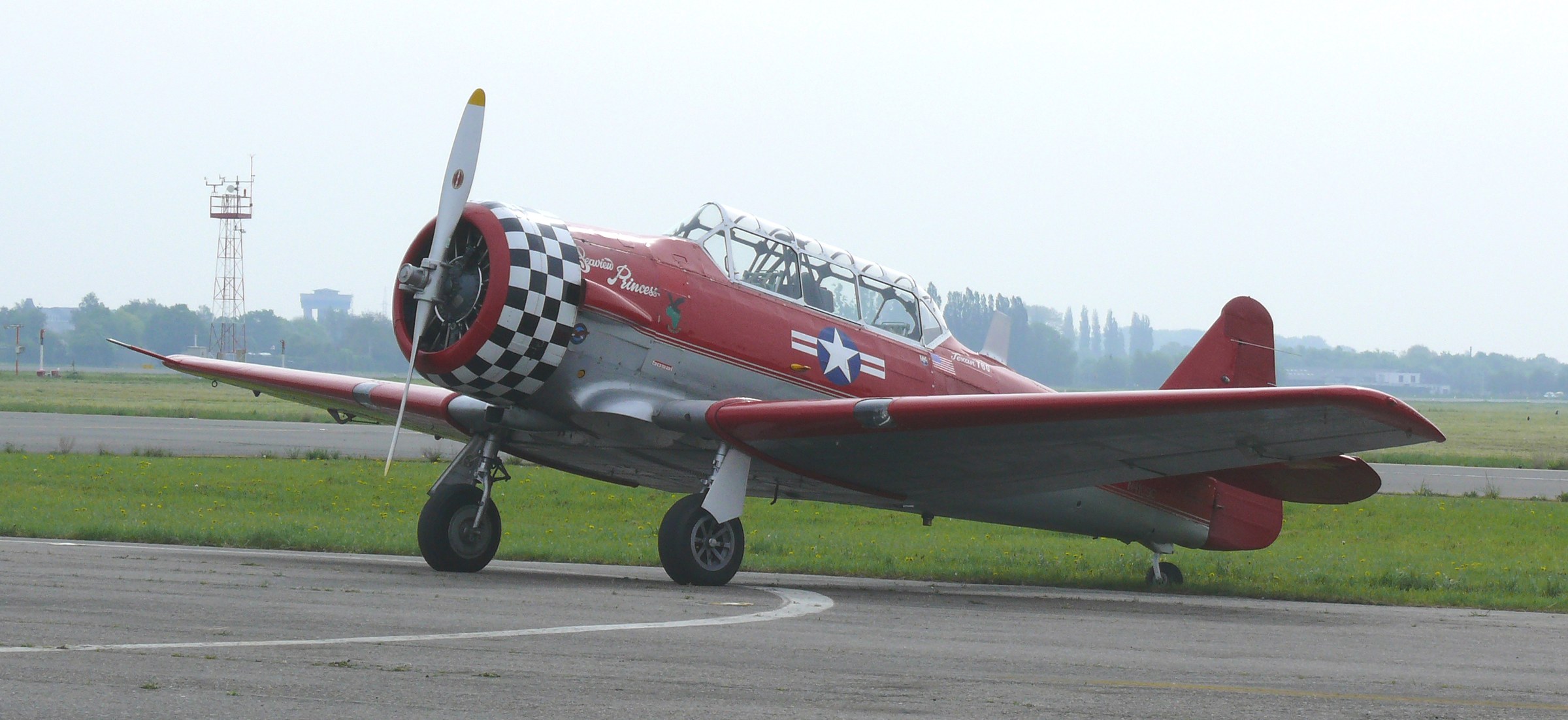
North American T-6G Texan. Credit: Ad Meskens (CC BY-SA 3.0), via Wikimedia Commons.
Duckworth was not simply an ordinary flight instructor who happened to find himself near a storm. At Bryan Field, Texas, he was responsible for advanced instrument-flight instruction, the discipline that teaches pilots to control an aircraft when cloud, rain or darkness removes the outside visual references normally used to judge attitude and direction. His experience in instrument flying was the technical background that made a deliberate penetration of a hurricane conceivable in a small trainer.
The November 1943 Monthly Weather Review identified Second Lt. Ralph M. O’Hair as Duckworth’s navigator on the first flight and First Lt. William H. Jones-Burdick as the pilot weather officer on the second. It reported that the flights ranged from about 1 220 to 2 740 m (4 000 to 9 000 feet) and described the first passage as “the first time, to our knowledge, that a plane has been intentionally flown through the center of a hurricane.” The contemporary report printed Duckworth’s middle initial as “P.”; later NOAA historical material identifies him as Joseph B. Duckworth.
Duckworth’s report to the Weather Bureau describes the transition from cloud and rain into an eye where the crew could see the sun and the ground. From the aircraft, he judged the eye to resemble a leaning cone because the visible ground wind and the apparent position of the calm region changed with altitude. He also reported that the turbulence and rain encountered during the two penetrations were less severe than conditions he had experienced in strong thunderstorms.
The first pass was an intentional penetration and observation flight, but the surviving Weather Bureau account does not describe it as a systematic meteorological sampling mission. Jones-Burdick’s presence on the second flight added a trained weather officer to the aircraft. Neal Dorst’s 2024 historical reconstruction says Jones-Burdick recorded temperature observations during that second penetration, while the 1943 Weather Bureau account identifies him specifically as a pilot weather officer.
The motive for the flight became less clear as the story was retold. A later version described British Royal Air Force pilots at Bryan Field questioning American aircraft and challenging Duckworth to prove that the AT-6 could handle the storm, followed by an unauthorized flight, an angry superior and a decision to reward rather than punish him. Dorst’s archival reconstruction rejects that sequence. He reported that no RAF pilots were training at Bryan Field, that Duckworth flew because he was curious and wanted to test the aircraft in rough conditions, and that he already had broad permission from Gen. Henry “Hap” Arnold to fly in severe weather.
The hurricane itself was a compact but destructive Gulf storm, not merely a backdrop to the aviation episode. A National Hurricane Center reanalysis published in 2014 lists the cyclone at 18:00 UTC on July 27 with maximum winds of 90 kt, about 167 km/h (104 mph), corresponding to Category 2 on the Saffir-Simpson Hurricane Wind Scale. The reanalysis assigns a central pressure of 967 hPa and a radius of maximum wind of about 28 km (17 miles).
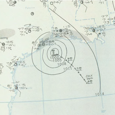
The observations available in 1943 recorded lower winds at individual stations than the modern reconstructed maximum for the cyclone as a whole. Galveston Airport measured a maximum wind of 119 km/h (74 mph), Houston Airport 137 km/h (85 mph), and Texas City recorded a gust of 167 km/h (104 mph). Reports placed the eye at about 19 to 23 km (12 to 14 miles) across as the hurricane moved inland.
The Weather Bureau reported the lowest observed pressure as 980 hPa, recorded at both its Galveston city office and Houston Airport. That figure is not the same quantity as the 967 hPa central pressure in the later HURDAT2 reanalysis. The first is a pressure measured at available observing sites during the storm; the second is a modern reconstruction of the cyclone’s central pressure from the historical evidence.
Rainfall exceeded 432 mm (17 inches) at both Port Arthur and La Porte. The Weather Bureau estimated damage at USD 10 million in the Galveston area, USD 6.25 million around Houston and USD 300 000 around Port Arthur, for about USD 16.55 million in 1943 dollars. Nineteen people were reported killed. Eleven died when the U.S. Engineer dredge Galveston sank after striking the north jetty at the entrance to Galveston Bay, and three more died aboard the tug Titan.

The limited warning before the Texas landfall was part of a larger wartime observing problem. Ship positions and their weather reports were treated as sensitive information during World War II, removing observations the U.S. Weather Bureau had relied on to locate tropical cyclones over the ocean. Dorst describes the result as a return of the older “lost hurricane” problem: storms could remain poorly located until they approached populated coastlines.
That wartime problem is also why Duckworth’s flight should not be treated as the moment when one dare suddenly created hurricane reconnaissance. Dorst found that the Weather Bureau and military were already working on aircraft reconnaissance before July 27 and that the newly coordinated hurricane operation in Miami had begun tasking military aircraft to monitor tropical disturbances. His reconstruction concludes that Duckworth’s flight played no role in setting that effort in motion.
The National Hurricane Center reanalysis draws a similar distinction between the July flights and operational reconnaissance. It identifies Duckworth’s two penetrations as the first intentional hurricane-center flights documented in the 1943 Weather Bureau record, but places the first aircraft report used operationally by the Miami Weather Bureau on August 16, 1943. Additional ad hoc flights followed, and aircraft monitoring developed over the next several years into formal U.S. military hurricane reconnaissance.
The August 16 report marked the transition from experimental or ad hoc hurricane flying toward aircraft observations delivered directly to forecasters. The Weather Bureau, U.S. Army Air Forces and U.S. Navy subsequently coordinated regular reconnaissance, turning airborne measurements into an operational part of tropical-cyclone analysis. Duckworth’s July flights remain a documented landmark in that chronology, but the surviving record separates the first known intentional eye penetration from the organized reconnaissance program that followed it.
References:
1 Sumner, H. C. (1943). North Atlantic hurricanes and tropical disturbances of 1943. Monthly Weather Review, 71(11), 179–183. NOAA/AOML archive copy
2 Dorst, N. (2024). Before the Hurricane Hunters: Storm Patrols and the Lost Hurricanes. Weatherwise, 77(1), 42–52. DOI: 10.1080/00431672.2024.2276648
3 Landsea, C. W., Hagen, A., Bredemeyer, W., Carrasco, C., Glenn, D. A., Santiago, A., Strahan-Sakoskie, D., & Dickinson, M. (2014). A reanalysis of the 1931–43 Atlantic hurricane database. Journal of Climate, 27(16), 6093–6118. DOI: 10.1175/JCLI-D-13-00503.1

I’m a science journalist and researcher at The Watchers, contributing to the Epicenter edition, where I cover peer-reviewed scientific research and emerging discoveries across Earth and space sciences. With a background in astronomy and a passion for environmental science, I’ve worked in shark and coral conservation in Fiji, conducting reef and shark-behavior research, contributing to mangrove restoration, and earning PADI Open Water and Coral Reef Certifications. I bring a blend of scientific rigor and storytelling to illuminate the discoveries shaping our planet and beyond.
Published in the last 24 hours
- Typhoon Cempaka spun up over the western North Pacific on 7 November 2026; it is now the 32nd typhoon of the year, more than any year this century, one past the 31 counted in 2013. Epicenter
- In 2013 a landslide fell onto Svínafellsjökull in southeast Iceland, leaving thicker ice at the foot of the slope; that ice is now moving away and the mountainside has shifted 1 to 3 cm. Epicenter
- Kīlauea's north vent threw lava about 660 feet (200 m) high for six hours on 5 November 2026; the summit is now reinflating, with the next episode forecast for 16 to 21 November. Epicenter
- A crack up to 6 m (20 ft) wide is splitting the summit of the Hochvogel in the Allgäu Alps; 12 years of measurements now put the loose block at about 400,000 cubic metres, half the peak. Epicenter
