
Hayli Gubbi in Ethiopia’s Afar erupted on 23 November 2025, its first historically documented eruption; a year later scientists have traced it to magma from Erta Ale that travelled more than 30 km underground.
Hayli Gubbi in Ethiopia’s Afar region produced its first historically documented eruption on November 23, 2025, after a July dyke from Erta Ale propagated 36 km (22 miles) south and intersected shallow magma storage beneath Hayli Gubbi. Peer-reviewed deformation studies show renewed magma transfer through the connected volcanic system before the eruption, while leaving the exact geometry of the underground plumbing unresolved.
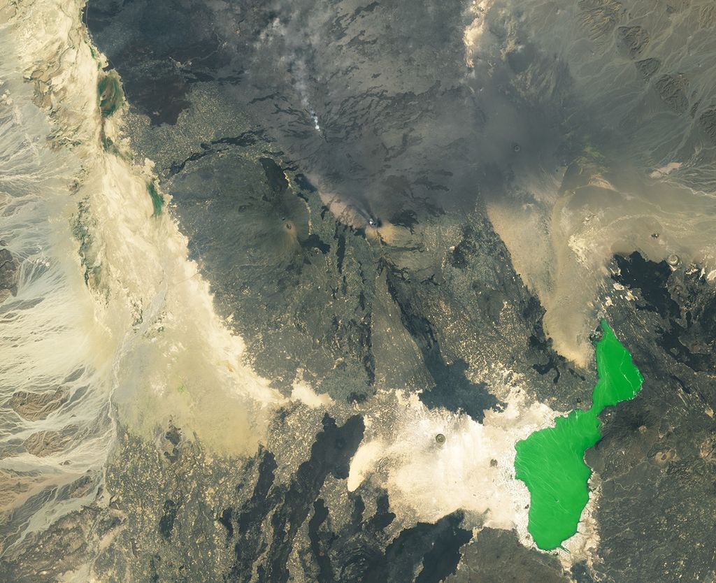
Landsat 9 imagery acquired on November 24, 2025 shows Hayli Gubbi, neighbouring Erta Ale and fresh ash deposits across the volcanic landscape. Credit: NASA Earth Observatory image by Michala Garrison, using Landsat data from the U.S. Geological Survey.
Ayalew et al. (2026) reconstructed the eruption using satellite deformation measurements, optical and infrared imagery, regional seismic records, field observations and tephra chemistry. Their analysis places the November event within a longer sequence that began at Erta Ale four months earlier and provides evidence that the two volcanic centres were structurally coupled rather than behaving as isolated systems.
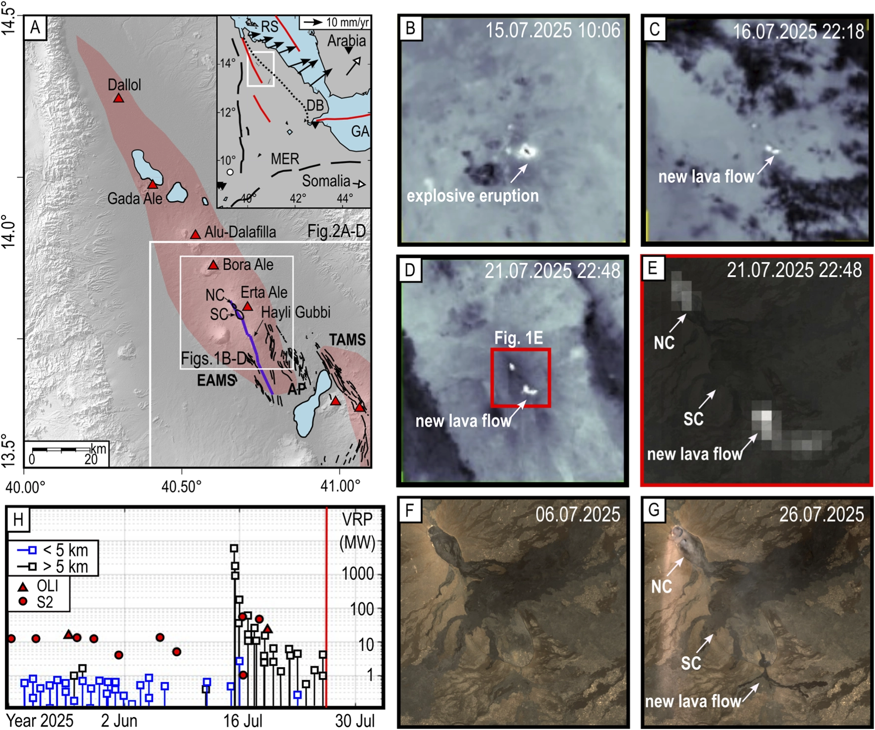
The sequence began with a small explosive eruption and collapse at Erta Ale’s northern summit caldera on July 15, 2025, followed by effusive activity. La Rosa et al. (2025) used satellite radar, optical imagery, pixel-offset measurements and seismicity to reconstruct a dyke that propagated 36 km (22 miles) south over 25 days and mobilized approximately 0.4 km3 (0.096 mi3) of mafic magma.
A dyke is a sheet-like body of magma that forces open a fracture as it moves through the crust. Interferometric Synthetic Aperture Radar (InSAR) does not directly image that magma. It measures changes in the distance between a radar satellite and the ground, allowing researchers to infer underground source geometry from patterns of uplift, subsidence and horizontal displacement.
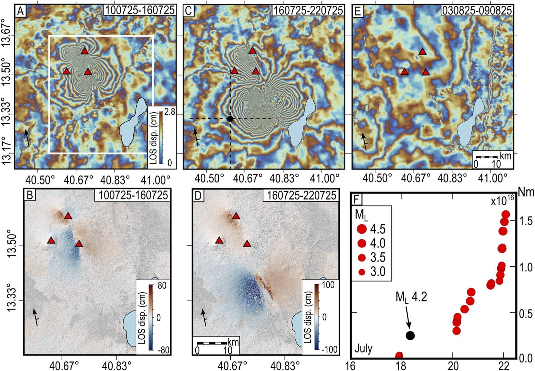
The July deformation developed in stages. Satellite measurements recorded strong deformation around Erta Ale before the intrusion propagated southeastward toward the Afrera Plain. The final reconstruction extended the intrusion 36 km (22 miles) from the northern end of the Erta Ale lava lake and showed multiple magma bodies operating at different crustal levels.
La Rosa et al. identified long-term inflation compatible with a sill at about 7.3 km (4.5 miles) depth beneath the broader system before July 2025, together with persistent dyke opening beneath Erta Ale. During the intrusion, shallow magma storage developed or changed beneath several parts of the volcanic segment rather than magma moving through a single simple conduit.
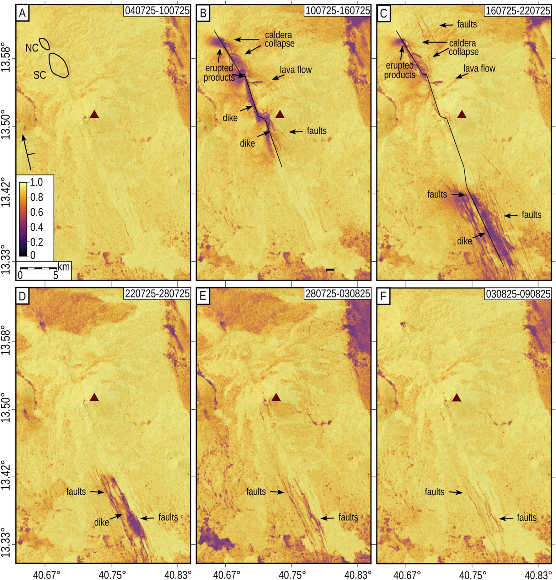
Hayli Gubbi inflated between July 22 and August 9 as the intrusion reached the southern part of the volcanic range. Ayalew et al. later incorporated this stage into their reconstruction of the November eruption, interpreting it as the first part of a two-stage connection between Erta Ale and Hayli Gubbi rather than a single uninterrupted 36 km magma journey immediately before the eruption.
Ground deformation resumed at Erta Ale in late September and continued toward the Hayli Gubbi eruption. Ayalew et al. modeled the pre-eruptive deformation with contracting dyke segments extending a combined 11 km (6.8 miles) from the Erta Ale calderas toward Hayli Gubbi, where minor uplift was recorded. They interpret the September-November pattern as progressive magma transfer through a connection established during the July intrusion.
Optical satellite imagery recorded another change at Hayli Gubbi during the same interval. Diffuse white clouds appeared intermittently inside the central summit crater from late July, became especially dense during parts of October and reappeared during the week before the eruption. The researchers propose that the clouds represented steam released from a hydrothermal system disturbed by magma intrusion. The imagery does not directly show magma reaching the surface.
Satellite imagery constrains the explosive eruption onset to between 10:54 and 11:31 LT (07:54–08:31 UTC) on November 23. The first optical image clearly showing an ascending grey-brown ash plume was acquired at 08:31 UTC, while an image obtained 35 minutes earlier showed no eruption. Toulouse Volcanic Ash Advisory Centre later used 08:30 UTC as the eruption time in its advisories.
The first strong regional seismic signal followed the visible onset of the eruption. Permanent stations in Ethiopia, Djibouti and Yemen recorded continuous low-frequency, high-amplitude activity between 08:44 and 09:10 UTC, with two distinct peaks between approximately 08:50 and 09:00 UTC. Ayalew et al. interpret the sequence as evidence that the initial plume developed before the most energetic seismic phase.
The eruption generated two plume lobes at different elevations. Satellite estimates placed a lower grey-cream plume at approximately 4–5 km (2.5–3.1 miles) elevation spreading northwest, while a higher plume reached about 10–12 km (6.2–7.5 miles) and moved east. Toulouse VAAC advisories tracked volcanic ash as high as flight level 450, approximately 13.7 km (8.5 miles) above sea level.
The eruption changed the summit morphology of Hayli Gubbi. Optical imagery recorded two new circular craters approximately 230 m (755 feet) and 100 m (328 feet) across southeast of the pre-existing central crater, together with new fractures. At Erta Ale, collapse during the same broad sequence produced a new caldera approximately 650 m (2 130 feet) long and 350 m (1 150 feet) wide.

The two plume directions also produced different dispersal patterns. The higher eastern plume transported ash and volcanic gases toward the Arabian Peninsula and South Asia, while the lower northern plume deposited ash across the Afar Depression toward Dallol.
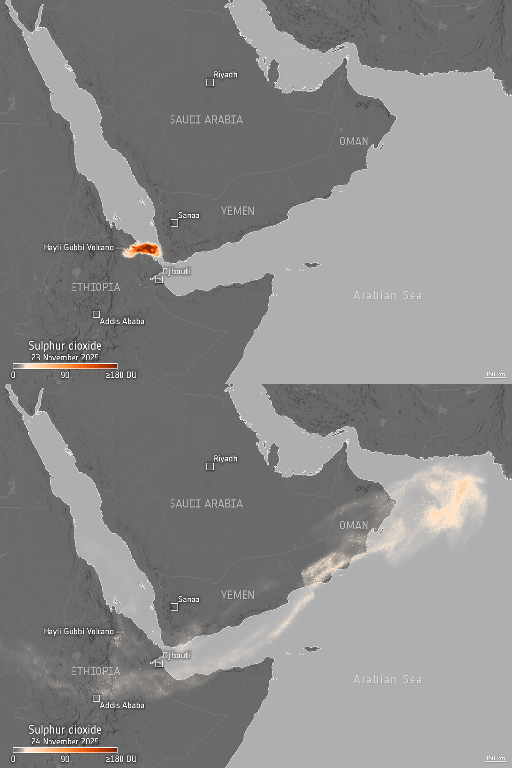
ESA’s Sentinel-5P observations show the sulphur dioxide plume leaving Ethiopia and spreading eastward on November 23 before extending northeast along Yemen, Oman and the Arabian Sea on November 24. The satellite carries the Tropomi instrument, which maps atmospheric trace gases and aerosols and allowed the gas plume to be followed independently of visible ash.
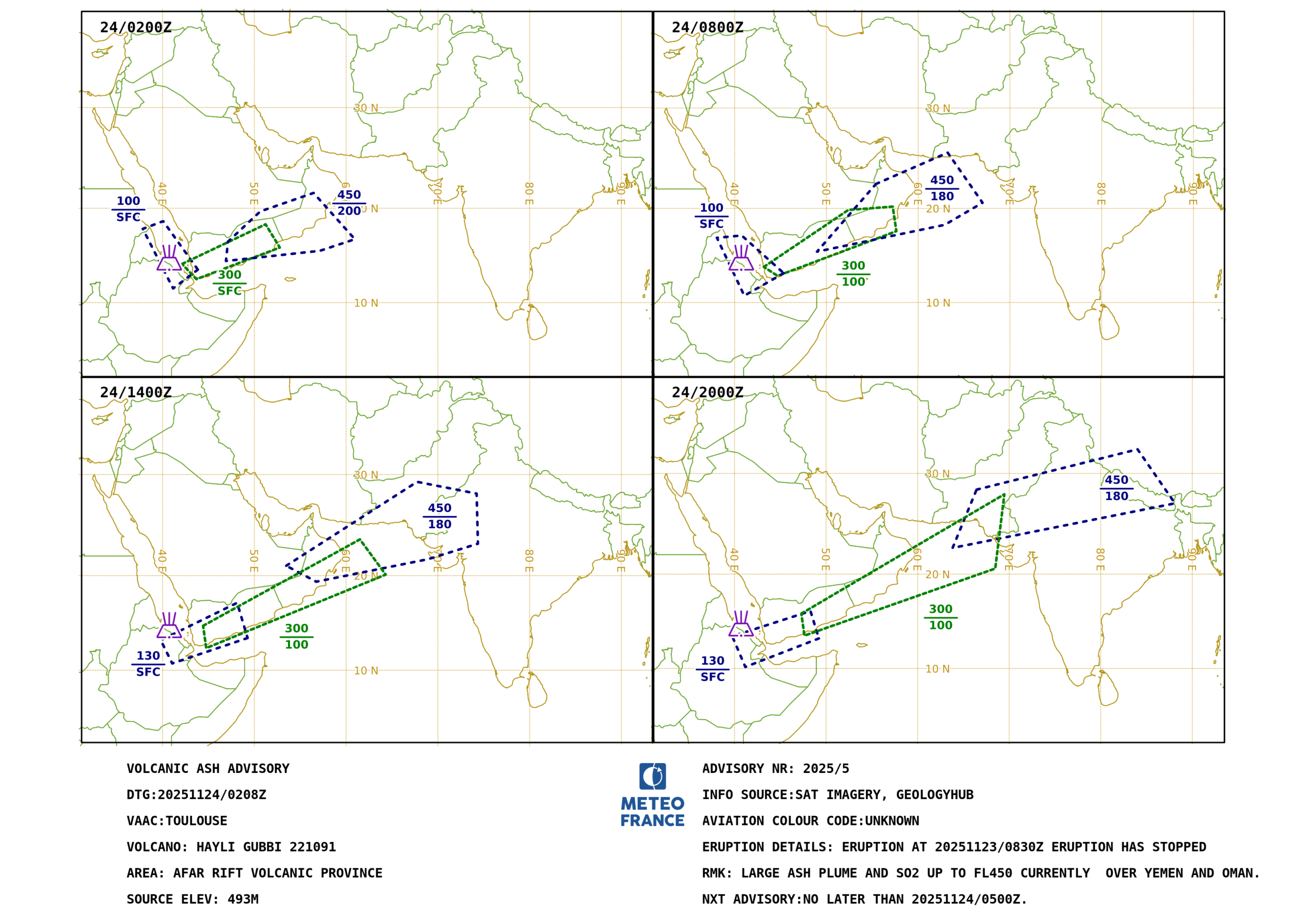
Toulouse VAAC reported that the eruption had stopped by the time of its November 24 advisories, but ash remained airborne and continued moving across the region. The advisory issued at 02:08 UTC tracked ash and gas over Yemen and Oman and retained volcanic ash forecasts up to flight level 450. Responsibility for the eastward-moving cloud was later transferred to the Tokyo VAAC as the plume crossed South Asia.

Field observations show how rapidly the northern deposit thinned with distance. Within 1 km (0.6 miles) of the crater, researchers measured a relatively well-sorted fallout layer about 15 cm (5.9 inches) thick over, in some places, approximately 75 cm (30 inches) of poorly sorted material. They interpret the lower deposit as material from a localized pyroclastic density current that filled depressions in older lava-flow topography.
At approximately 2 km (1.2 miles) northwest of the crater, the fall deposit was about 5–10 cm (2–3.9 inches) thick and contained fragments up to about 3.5 cm (1.4 inches). At 11.5 km (7.1 miles), the layer had thinned to approximately 5 mm (0.2 inches). Ash was still identifiable on the Dallol salt plain about 90 km (56 miles) north-northwest of the source.
Using an assumed distal thickness of approximately 1 mm (0.04 inches) at Dallol and the observed elliptical dispersal pattern, Ayalew et al. estimated a minimum northern-deposit volume of about 1.6 × 10⁷ m³, or 0.016 km³ (0.0038 mi³). The eastern lobe could not be mapped in the same way. The authors conservatively estimate total erupted deposits at approximately 3–4.5 × 10⁷ m³, or 0.03–0.045 km³ (0.0072–0.011 mi³), but state that detailed deposit mapping is needed to refine the value.
The ash was not composed entirely of fresh juvenile magma. A sample collected 11.5 km (7.1 miles) northwest of the summit contained approximately 20–25% visibly vesicular black particles interpreted as probably juvenile, together with crystals, hydrothermally altered fragments and other lithic material. The tephra and glass analyses span approximately 52–55 wt. % SiO2 and fall around the basaltic-andesite to basaltic-trachyandesite boundary.
The available chemistry does not establish whether the eruption involved one evolving melt or several chemically distinct magma batches. Ayalew et al. found that variable crystal fractionation can explain the glass compositions, but the limited analyses do not eliminate other interpretations. Abundant altered rock fragments also mean the bulk ash chemistry cannot be treated as the composition of juvenile magma alone.
Direct impacts remained limited because of the remote setting. Ayalew et al. found no reported casualties or damage to property or infrastructure. Nearby communities experienced ashfall, three residents interviewed after the eruption reported five camels and fifteen goats missing, and salt extraction around Dallol and Lake Afrera was interrupted for about one to two days.
The eruption was widely described in contemporary coverage as Hayli Gubbi’s first eruption in 10 000 or 12 000 years, but the peer-reviewed reconstruction does not establish such an interval. No absolute chronology exists for Hayli Gubbi’s prehistoric eruptions, and the young appearance of its craters and lava flows is consistent with repeated Holocene activity. The supported description is therefore its first historically documented eruption.
Co-eruptive deformation strengthens the evidence for a connection with Erta Ale. Ayalew et al. modeled contracting dyke-shaped sources beneath Erta Ale together with a contracting sill approximately 1.5 km (0.9 miles) beneath Hayli Gubbi. The Hayli Gubbi sill was modeled as approximately 2.5 km (1.6 miles) long and 0.5 km (0.3 miles) wide.
The model explains most of the measured surface displacement, but a residual deformation signal remains between the southern end of the Erta Ale source and the Hayli Gubbi sill. The authors interpret the residual as evidence for a physical connection not fully represented by their simplified source model.
Shrivastava et al. (2026) independently examined six InSAR pairs spanning November 7 to December 13, 2025. Their co-eruptive observations recorded maximum subsidence of about 10 cm (3.9 inches), and a coupled two-reservoir model was strongly preferred over a single-source alternative. In that model, volume loss beneath Erta Ale was approximately 2.4 times that beneath Hayli Gubbi.
Neither deformation study directly images a conduit between the two volcanoes. Both infer underground sources from surface deformation, and the Ayalew model explicitly leaves part of the measured signal unresolved. The combined results strengthen the case for a linked volcanic system without establishing the exact shape, dimensions or persistence of every subsurface pathway.
Thermal activity continued after the eruption without establishing another eruptive episode. Satellite observations detected a localized hotspot at Hayli Gubbi on November 23 that weakened during the following week. A faint anomaly occasionally reappeared over subsequent months, with the latest occurrence reported by Ayalew et al. on May 16, 2026. Because molten lava was not observed after the eruption, the researchers propose that part of the thermal signal may have originated from hot fumarolic gases.
The 2025 sequence was reconstructed largely from satellites because the region lacks a dedicated ground-based volcano-monitoring network. InSAR measured deformation across the remote volcanic range while optical, infrared and atmospheric sensors documented crater changes, thermal anomalies, ash transport and gas emissions. Ayalew et al. argue that the eruption strengthens the case for expanded volcano-monitoring capacity and data-supported hazard assessment in Ethiopia.
Important questions remain unresolved. The available geochemistry cannot determine whether one or several magma batches participated in the eruption, the deformation models do not completely resolve the pathway between Erta Ale and Hayli Gubbi, and the observations do not establish that a later intrusion would follow the same route. Future seismic, deformation, gas and petrological measurements would allow those interpretations to be tested if activity resumes along the volcanic range.
References:
1 Ayalew, D., Fontijn, K., Abdu, F. S., Keir, D., Tadesse, A. Z., Pagli, C., La Rosa, A., Tierz, P., Melaku, A., Hutchison, W., Sugden, P., Yirgu, G., Nigussie, A. M., Ahmed, O., Gebru, H., Mangler, M. F., Cooper, M. J., & Ayele, A. (2026). The first documented volcanic eruption of Hayli Gubbi, Afar, Ethiopia. Bulletin of Volcanology, 88, 78. DOI: 10.1007/s00445-026-01997-3
2 La Rosa, A., Pagli, C., Keir, D., Ayele, A., Wang, H., Rivalta, E., & Lewi, E. (2025). Segmented dike intrusion linked to multi-level magma storage during and before the 2025 eruption at Erta Ale (East Africa). Frontiers in Earth Science, 13, 1719687. DOI: 10.3389/feart.2025.1719687
3 Shrivastava, M. N., Sunil, A. S., Torres Gaete, B., Maurya, A. K., Aguilera, F., Sunil, P. S., Gonzalez, R., & Salazar, P. (2026). Hayli Gubbi and Erta Ale volcanic eruptions (2025): InSAR-derived pre-, co-, and post-eruptive deformations. Natural Hazards, 122, 712. DOI: 10.1007/s11069-026-08423-z
4 Hayli Gubbi’s Explosive First Impression – NASA Earth Observatory – December 4, 2025
5 Ethiopian volcanic plume – European Space Agency – November 25, 2025
6 The new morphology of the Hayli Gubbi volcano – Copernicus / EU Space – November 28, 2025
7 HAYLI GUBBI.5 volcanic ash advisory – Toulouse Volcanic Ash Advisory Centre – November 24, 2025, 02:08 UTC

I’m a science journalist and researcher at The Watchers, contributing to the Epicenter edition, where I cover peer-reviewed scientific research and emerging discoveries across Earth and space sciences. With a background in astronomy and a passion for environmental science, I’ve worked in shark and coral conservation in Fiji, conducting reef and shark-behavior research, contributing to mangrove restoration, and earning PADI Open Water and Coral Reef Certifications. I bring a blend of scientific rigor and storytelling to illuminate the discoveries shaping our planet and beyond.
Published in the last 24 hours
- A crack up to 6 m (20 ft) wide is splitting the summit of the Hochvogel in the Allgäu Alps; 12 years of measurements now put the loose block at about 400,000 cubic metres, half the peak. Epicenter
- Typhoon Cempaka spun up over the western North Pacific on 7 November 2026; it is now the 32nd typhoon of the year, more than any year this century, one past the 31 counted in 2013. Epicenter
- A school bus driver in Paradise, California, drove 22 children through the 2018 Camp Fire for about five hours, and when the smoke thickened, he and two teachers tore his shirt into wet strips for them to breathe through Epicenter
- Mount Pinatubo in the Philippines sits about 7,000 miles from California, yet after it erupted in 1991 the whole planet cooled by about 1°F for nearly two years, because the sulfur it blasted into the sky formed a thin haze that bounced sunlight back into space Epicenter
