
A crack up to 6 m (20 ft) wide is splitting the summit of the Hochvogel in the Allgäu Alps; 12 years of measurements now put the loose block at about 400,000 cubic metres, half the peak.
Researchers at the Technical University of Munich are recording movement of up to 5 mm (0.2 inches) per week in the unstable summit of the 2 592 m (8 504 feet) Hochvogel on the Germany–Austria border. Years of monitoring have turned the fractured peak into a rare natural laboratory for observing how water, progressive rock damage and changing deformation prepare a large rock slope for failure, while testing whether its final acceleration can eventually be recognized with useful warning time.
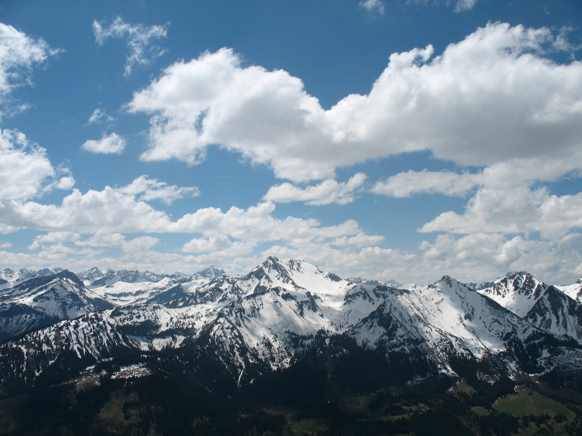
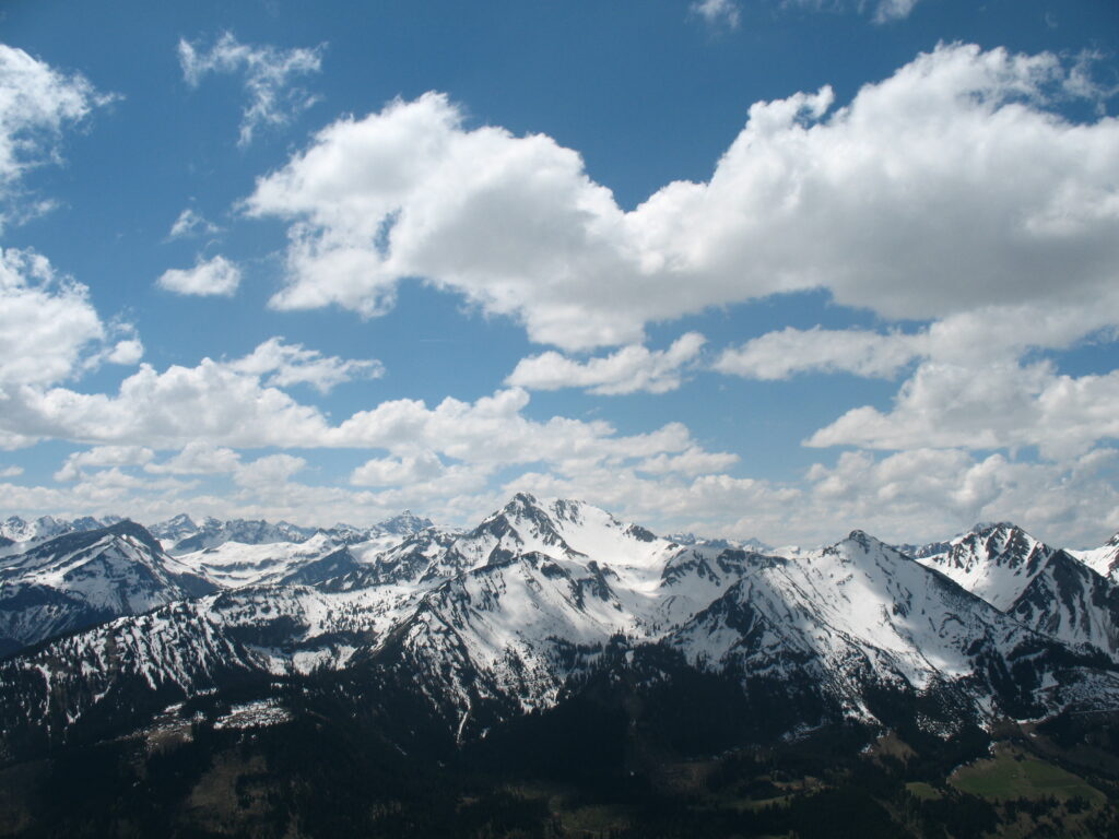
Gaishorn vom Einstein. Credit: Kauk0r (CC BY-SA 3.0), via Wikimedia Commons.
The latest measurements come from a fracture system that has been developing for decades rather than a newly formed crack. In an update published on November 11, 2026, the Technical University of Munich (TUM) described a prominent summit fissure about 40 m (131 feet) long, 8 m (26 feet) deep and 3 m (10 feet) wide. Instruments have registered unusually fast movement of up to 5 mm (0.2 inches) per week since spring 2026.
TUM’s engineering geodesy team has monitored Hochvogel with multiple methods since 2018. Terrestrial and permanent laser scanning, GNSS, photogrammetry, drone LiDAR, conventional geodetic network measurements and camera systems are used to distinguish stable areas from blocks that are shifting at millimetre scale.
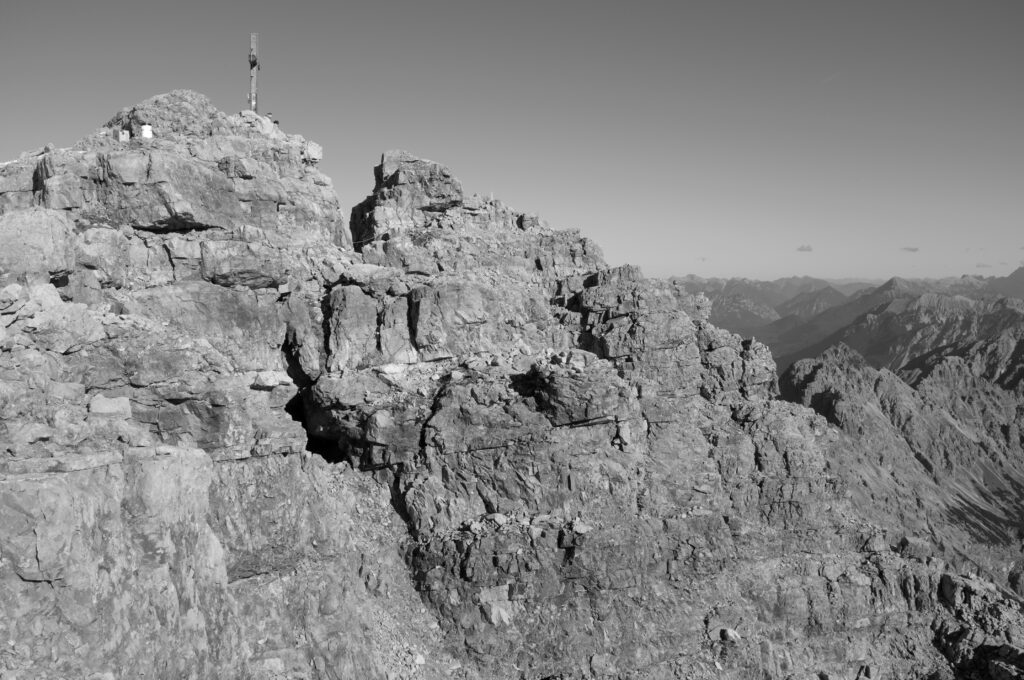
The dimensions reported by different studies describe different parts or definitions of the fractured summit and should not be combined into one geometric measurement. Leinauer et al. (2024) describe the main crack as 2–6 m (7–20 feet) wide, separating a relatively stable northeastern side from an unstable southwestern side. The 2026 TUM dimensions refer to a prominent fissure described by the current geodetic monitoring program.
The same distinction applies to the amount of rock involved. The 2024 study calculated about 260 000 m3 (340 000 cubic yards) of unstable rock above a distinct 1 m (3.3 feet) thick marly layer beneath the summit. When potentially unstable rock below that layer is included, the calculated volume rises to 400 000–600 000 m3 (523 000–785 000 cubic yards).
These are structural definitions rather than successive versions of one settled number. Describing 400 000 m3 as both the definitive volume and “half the mountain” therefore compresses different estimates into a claim the primary research does not make.
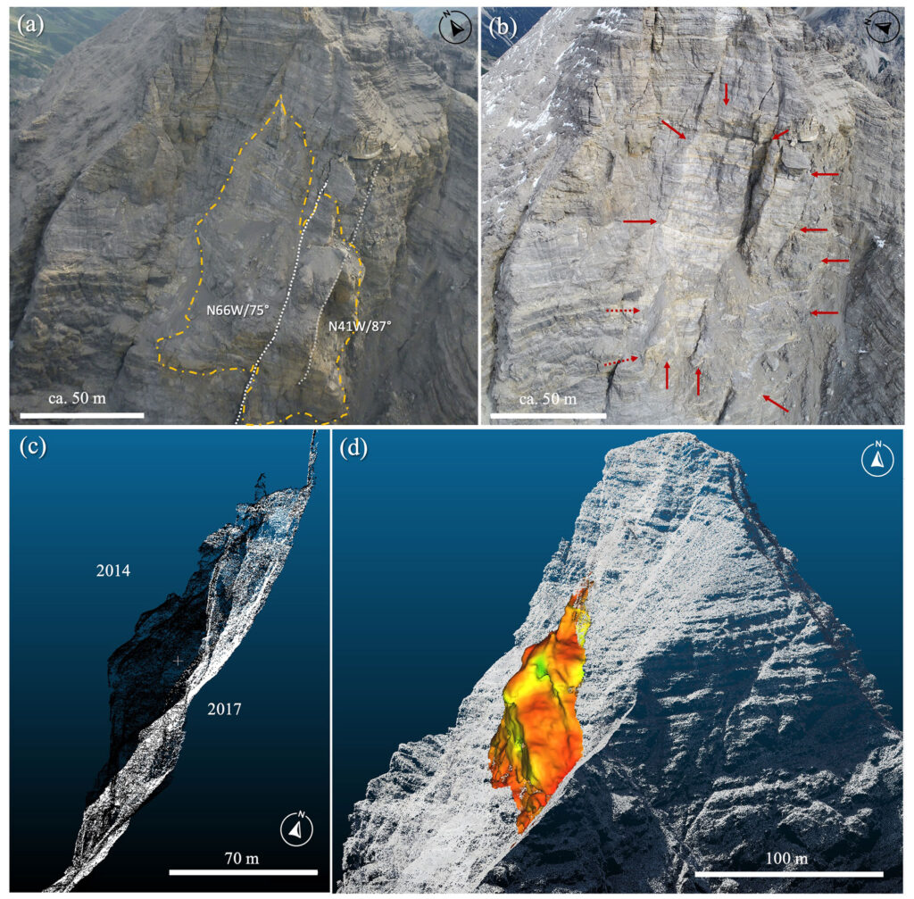
The unstable rock mass has been developing since at least the 1940s. Leinauer et al. reported deformation rates of about 2 cm (0.8 inches) per year during the two decades preceding their study, while several lateral cracks on the steep southwestern wall became more active. A multi-stage cliff fall on that flank released more than 130 000 m3 (170 000 cubic yards) of rock during summer 2016.
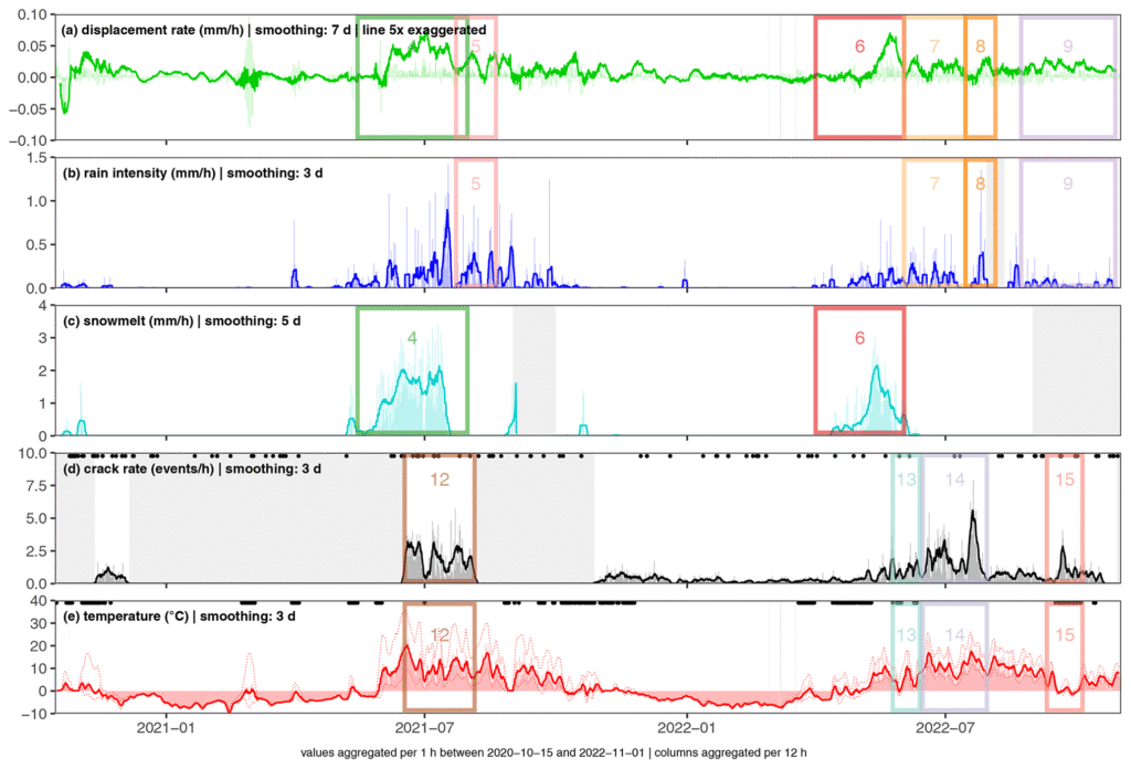
Understanding what controls movement before a larger failure is the central scientific problem at Hochvogel. Leinauer et al. analyzed more than four years of high-resolution observations, including crack opening, rainfall, modeled snowmelt, air temperature, rock-fracturing signals and earthquake records. The monitoring period used for the environmental analysis extended from 2018 to 2022.
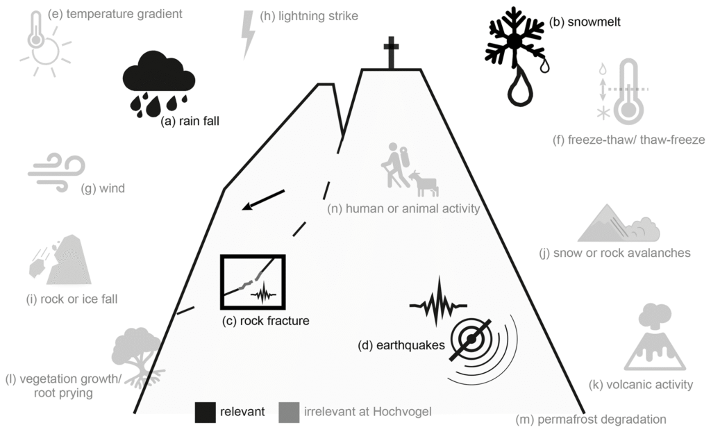
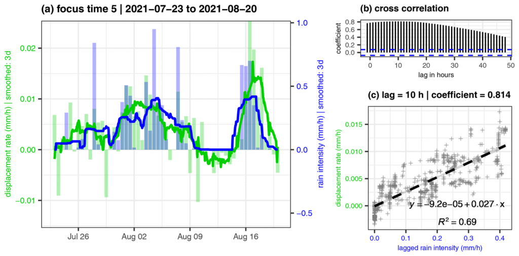
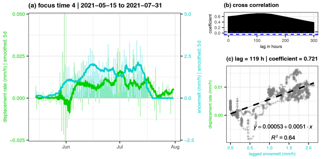
Water emerged as the strongest measured environmental control on displacement. During the spring snowmelt period, movement followed meltwater infiltration with a lag of about 4–9 days. During snow-free summer conditions, rainfall-related accelerations followed precipitation after about 1–16 hours and could persist for several days.
The delay has a physical meaning. Rainwater and meltwater entering open discontinuities can raise hydrostatic pressure inside the fractured rock, reduce the effective normal stress pressing surfaces together and weaken resistance along parts of the sliding system. The researchers interpreted the observed rainfall lag as the time required for infiltration and pressure to build within those discontinuities.
The summer observations did not reveal a minimum rainfall-total threshold below which movement could not occur. More than 20 selected rainfall events across four summers showed the same general relationship, and even relatively small amounts of rainfall accelerated the mass under favorable internal conditions. During one well-constrained dry-period event, movement accelerated to about 1 mm (0.04 inches) per day before slowing again as water input decreased.
Snowmelt acts more slowly because meltwater supply is generally more sustained than a short summer rainstorm. Cross-correlation coefficients exceeded 0.75 during the main snowmelt period in each analyzed year, with the strongest relationship appearing 4–9 days after meltwater input.
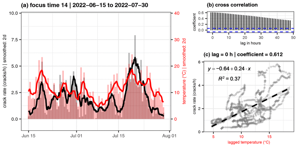
Temperature affects another part of the failure process. The seismic network detected 21 801 discrete events classified as rock cracking, with a median duration of about 1.4 seconds. Crack activity was generally greater during summer and was associated with temperature and freeze-thaw conditions, but the study found no stable direct relationship between the rate of those detected cracks and the displacement rate of the deeper unstable mass.
That distinction matters because much of the recorded temperature-sensitive fracturing occurred near the surface. Temperature can open and close shallow fractures over daily and seasonal cycles without controlling movement along the deeper potential failure surface in the same way as infiltrating water.
Earthquakes were also examined as a possible trigger. A Newmark analysis of recent and historical earthquakes found low potential for an immediate major failure at Hochvogel unless the slope is already extremely close to instability. Seismic ground motion can nevertheless be amplified at the summit: the calculated amplification of peak ground velocity ranged from a factor of 2 to 11 and varied across the fractured peak.
The second part of the research problem is recognizing when slow deformation enters the final accelerating phase before failure. Rock slopes commonly pass from relatively steady secondary creep into tertiary creep, a self-accelerating stage in which progressive damage leaves fewer intact rock bridges carrying the remaining load.
Leinauer et al. (2023) developed a prospective failure-time forecast model to identify that transition without choosing the most favorable part of a displacement record afterward. The method automatically searches for the onset of acceleration, processes several smoothing and velocity windows and continuously calculates both a predicted failure time and an uncertainty window as new measurements arrive.
The method was tested on 46 displacement datasets from 14 historical slope failures. At the actual failure time, the mean merged forecast was -1 ± 17 hours for higher-frequency datasets and -1 ± 4 days for daily datasets. The corresponding mean uncertainty was 1 ± 1 day and 7 ± 4 days. Higher-frequency observations generally produced better short-term performance.
Those statistics do not provide a failure date for Hochvogel. They describe how the forecasting method performed on historical failures after their accelerating phase had been detected. Applying such a system operationally still requires the slope to produce a sustained acceleration that can be distinguished from temporary movement caused by rainfall, snowmelt or other short-term changes.

The current TUM program approaches that problem with overlapping measurement systems rather than a single instrument. Its latest geodetic evaluations divide the unstable summit into two broad movement patterns: the largest part moves largely as a coherent block toward the southeast, while a southwestern subsection is separating further and moving toward the southwest. High-resolution measurements also resolve smaller changes such as individual blocks tilting, falling or shifting within loose debris.
Climate enters the problem through the environmental processes that supply water and alter near-surface fracturing, but the 2024 study does not establish anthropogenic climate change as the single direct cause of the 2026 acceleration. The authors found that future changes in rainfall intensity, rainfall frequency, snow accumulation and snowmelt timing can alter the preconditioning of large Alpine rock slopes. They also cautioned that the direct connection between climate change and increased rock-slope activity depends on how those controlling conditions change in a particular region.
The unresolved question is not whether Hochvogel is fractured or moving; both have been measured directly. The uncertainty lies in how the long preparation phase transitions into the sustained tertiary acceleration that precedes major failure. No peer-reviewed study or current TUM update examined for this article provides a calendar date for that transition or for the eventual large rock-slope failure.
The value of Hochvogel as a natural laboratory lies in capturing that transition if it occurs. Continuous deformation measurements, environmental observations and repeated three-dimensional surveys give researchers a chance to test whether the physical changes seen during decades of slow destabilization can be separated from the signals that mark the final approach to failure.
References:
1 Leinauer, J., Dietze, M., Knapp, S., Scandroglio, R., Jokel, M., & Krautblatter, M. (2024). How water, temperature, and seismicity control the preconditioning of massive rock slope failure (Hochvogel). Earth Surface Dynamics, 12, 1027–1048. DOI: 10.5194/esurf-12-1027-2024
2 Leinauer, J., Weber, S., Cicoira, A., Beutel, J., & Krautblatter, M. (2023). An approach for prospective forecasting of rock slope failure time. Communications Earth & Environment, 4, 253. DOI: 10.1038/s43247-023-00909-z
3 Hochvogel-Lab: Freiluftlabor für moderne Messtechnik – Technical University of Munich, School of Engineering and Design – November 11, 2026

I’m a science journalist and researcher at The Watchers, contributing to the Epicenter edition, where I cover peer-reviewed scientific research and emerging discoveries across Earth and space sciences. With a background in astronomy and a passion for environmental science, I’ve worked in shark and coral conservation in Fiji, conducting reef and shark-behavior research, contributing to mangrove restoration, and earning PADI Open Water and Coral Reef Certifications. I bring a blend of scientific rigor and storytelling to illuminate the discoveries shaping our planet and beyond.
Published in the last 24 hours
- Hayli Gubbi in Ethiopia's Afar erupted on 23 November 2025, its first historically documented eruption; a year later scientists have traced it to magma from Erta Ale that travelled more than 30 km underground. Epicenter
- Typhoon Cempaka spun up over the western North Pacific on 7 November 2026; it is now the 32nd typhoon of the year, more than any year this century, one past the 31 counted in 2013. Epicenter
- A school bus driver in Paradise, California, drove 22 children through the 2018 Camp Fire for about five hours, and when the smoke thickened, he and two teachers tore his shirt into wet strips for them to breathe through Epicenter
- Mount Pinatubo in the Philippines sits about 7,000 miles from California, yet after it erupted in 1991 the whole planet cooled by about 1°F for nearly two years, because the sulfur it blasted into the sky formed a thin haze that bounced sunlight back into space Epicenter
