
Over 20 000 evacuated as Typhoon Noul approaches Guangdong, up to 600 mm (24 inches) of rain forecast, China
Typhoon Noul is forecast to make landfall over eastern Guangdong by July 26, 2026, bringing a significant threat of flooding across southern China. More than 20 000 people have been evacuated Guangdong with rainfall totals of 500 to 600 mm (20 to 24 inches) forecast as the storm approaches. Authorities have raised Guangdong’s emergency response for flood and typhoon control to Level III on July 25 as Typhoon Noul approached the province, while activating a Level IV flood emergency response for Jiangxi and Hunan.
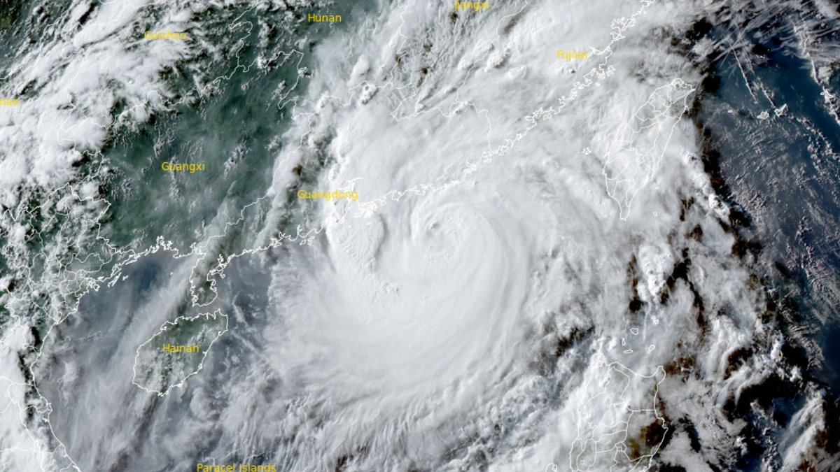
Satellite image of typhoon Noul at 09:50 UTC on July 25, 2026. Credit: JMA/Himawari-9, RAMMB/CIRA, The Watchers
Typhoon Noul, known locally in the Philippines as Kiyapo, intensified over the northeastern South China Sea on July 25, after crossing northern Luzon and the Babuyan Islands a day earlier.
More than 20 000 people had been evacuated in Guangdong through July 24 as the typhoon approached the Chinese mainland. China’s State Flood Control and Drought Relief Headquarters raised its emergency response for flood and typhoon control in Guangdong to Level 3 on July 25 as Noul strengthened, while also activating a Level 4 flood emergency response for Jiangxi and Hunan provinces.
As of 09:00 UTC on July 25, the Joint Typhoon Warning Center (JTWC) placed Noul about 437 km (272 miles) east of Hong Kong with 1-minute maximum sustained winds of 140 km/h (87 mph). The cyclone was moving west-northwest at 28 km/h (17 mph), generating significant wave heights of up to 9 m (30 feet).
The Hong Kong Observatory reported that at 19:00 HKT (11:00 UTC) on July 25, Noul was producing 10-minute maximum sustained winds of approximately 140 km/h (87 mph) while tracking steadily across the northeastern South China Sea toward eastern Guangdong. China’s National Meteorological Center (NMC) estimated the typhoon’s minimum central pressure at 965 hPa.
Forecast guidance from the JTWC, NMC, and other operational agencies indicated landfall near the cities of Huizhou and Shanwei. The JTWC projected landfall within 12 hours from its 09:00 UTC advisory on July 25, with peak 1-minute sustained winds reaching up to 158 km/h (98 mph) before the cyclone moves inland and gradually weakens.
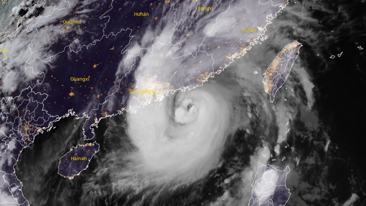
The primary hazard is expected to be heavy rainfall across southeastern Guangdong and southern Fujian. NMC forecasts widespread rainfall with localized accumulations of 500 to 600 mm (20 to 24 inches), capable of producing flash flooding, river flooding, urban inundation, landslides, and debris flows, particularly across mountainous terrain and densely populated river basins.
Much of southern China has experienced repeated heavy rainfall during July, leaving soils saturated and river levels elevated. Additional rainfall associated with Noul is therefore expected to increase the likelihood of secondary hazards, including slope failures and rapidly developing flash floods.
Rail operators announced the suspension of both high-speed and conventional train services in parts of Guangdong. Provincial authorities suspended some train services on Saturday morning, with all provincial train services scheduled to halt on Sunday, according to CCTV.
Schools in Chaozhou were instructed to suspend on-campus activities, according to local media. Zhuhai suspended ferry operations and closed coastal tourist attractions, while fishing vessels were ordered back to port and emergency agencies prepared for potential coastal flooding and wind damage.
Cathay Pacific canceled all flights scheduled to arrive at or depart from Hong Kong International Airport on July 27. The Hong Kong Observatory warned that easterly winds would strengthen steadily as Noul approached, bringing squally thunderstorms, rough seas, and dangerous surf. Forecasters added that tropical cyclone warning signals would be upgraded if the storm continued along its forecast track toward eastern Guangdong.
Although Taiwan remained outside the cyclone’s core circulation, the Central Weather Administration reported periods of heavy rainfall across eastern Taiwan and the Hengchun Peninsula together with rough marine conditions south of the island. The agency attributed Noul’s continued strengthening to persistently warm sea surface temperatures and otherwise favorable atmospheric conditions over the South China Sea.
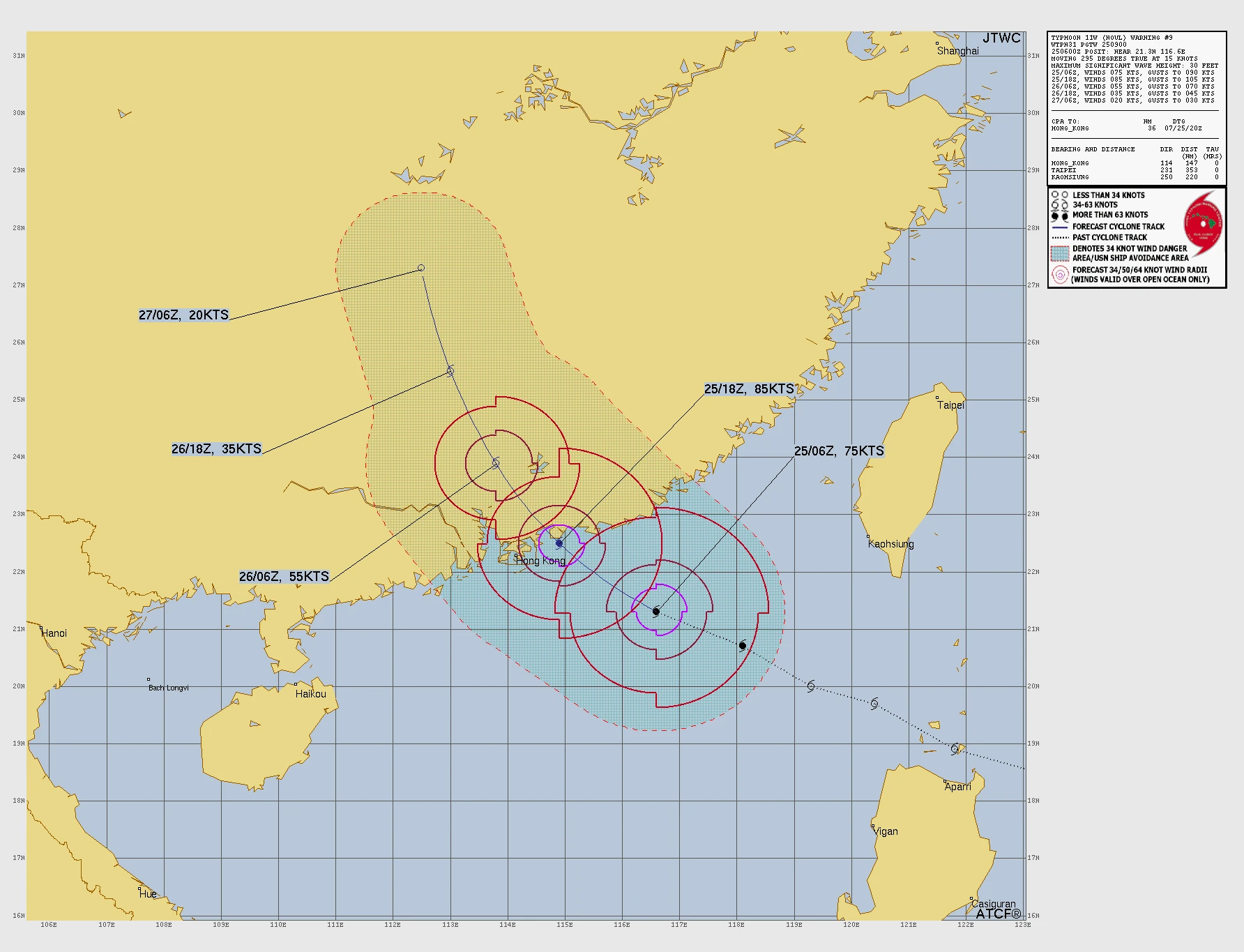
Noul is forecast to weaken steadily after moving inland across Guangdong as interaction with rugged terrain disrupts the cyclone’s circulation. Nevertheless, heavy rainfall is expected to continue well inland after landfall, maintaining a significant flood threat even as damaging winds gradually subside.
Noul originated as a tropical disturbance over the western Philippine Sea before organizing into a tropical depression east of Luzon. The system strengthened into a tropical storm before making landfall over Camiguin Island, Calayan, Cagayan, during the afternoon of July 24. It then crossed the Babuyan Islands and emerged over the West Philippine Sea.
PAGASA designated the system a tropical storm at 04:00 PHT (20:00 UTC on July 23). It made landfall at approximately 14:10 PHT (06:10 UTC) on July 24 and crossed into the coastal waters of Calayan Island by 16:00 PHT (08:00 UTC) the same day.
By 20:00 PHT (12:00 UTC) on July 24, PAGASA upgraded the cyclone to a severe tropical storm after it strengthened over warm waters west of northern Luzon. At 23:00 PHT (15:00 UTC), the agency classified the system as a Severe Tropical Storm with 10-minute maximum sustained winds of 95 km/h (59 mph), gusts reaching 130 km/h (81 mph), and an estimated minimum central pressure of 985 hPa. By early July 25, Philippine authorities upgraded Kiyapo to typhoon intensity while noting that the system was no longer expected to directly affect the country apart from rough seas and residual rainbands.
Preparedness measures and emergency response in the Philippines reduced the storm’s immediate impacts. Preemptive evacuations in three towns in Cagayan moved at least 95 people out of vulnerable areas before landfall. The Philippine Coast Guard rescued at least 20 people stranded in floodwaters in Jordan, Guimaras, and Hamtic, Antique, on July 24. Earlier operations also included the evacuation of 240 people in Sarangani due to flooding associated with the southwest monsoon (Habagat), which was enhanced by Noul.
References:
1 Prognostic reasoning for Typhoon Noul – JTWC – July 25, 2026
2 Tropical Cyclone Position – HKO – July 25, 2026
3 China raises emergency response as Typhoon Noul nears – Xinhua – July 25, 2026
4China evacuates 20,000 people as Typhoon Noul nears – CNA – July 25, 2026

I am an Assistant Editor and Severe Weather & Science Journalist at The Watchers, specializing in real-time severe weather coverage, geophysical event reporting, and research-driven scientific analysis. You can reach me at rishav(at)watchers(.)news.

Commenting rules and guidelines
We value the thoughts and opinions of our readers and welcome healthy discussions on our website. In order to maintain a respectful and positive community, we ask that all commenters follow these rules.