
Mayon erupts as Alert Level rises to 3 and ash spreads south, Philippines
An explosive eruption occurred at Mayon Volcano in Albay, Philippines, at 11:53 LT on October 30, 2026, sending a dense ash plume 3 000 m (9 843 feet) above the summit crater and prompting DOST-PHIVOLCS to raise the volcano from Alert Level 2 to Alert Level 3. By 19:20 LT, Tokyo VAAC was still detecting volcanic ash in Himawari-9 satellite imagery moving south, with ash analyzed up to FL180 and forecast up to FL190 during the following six hours.
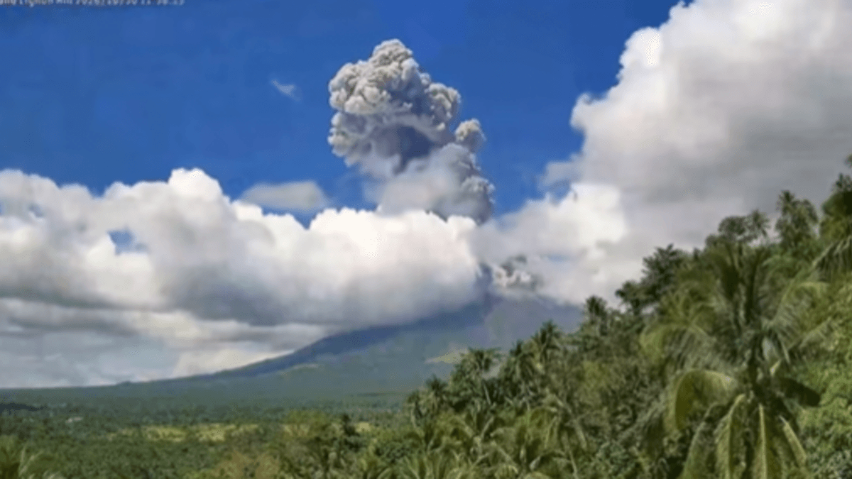
Mayon Volcano produces an ash column during the moderately explosive eruption on October 30, 2026. DOST-PHIVOLCS raised the volcano to Alert Level 3 after the eruption. Credit: DOST-PHIVOLCS
PHIVOLCS said Alert Level 3 means an increased tendency toward a hazardous eruption and described the October 30 activity as a new phase of magmatic eruption, with increased chances of lava flows and hazardous pyroclastic density currents affecting the upper to middle slopes in the immediate days to weeks.
The eruption generated a dense, rapidly ascending and billowing ash plume that reached 3 000 m (9 843 feet) above the summit crater. Moderate winds carried the plume west-southwest, while PHIVOLCS expected ashfall in Daraga, Guinobatan, Camalig and adjacent municipalities in Albay.
PHIVOLCS recommended evacuation of the 6-km (3.7-mile) Permanent Danger Zone because of pyroclastic density currents, lava flows, rockfalls and other volcanic hazards. Pyroclastic density currents, locally called uson, are fast-moving mixtures of hot gas, ash and volcanic fragments that move downslope under gravity and can extend rapidly away from an erupting vent.
Increased vigilance was also advised along channels draining Mayon because of the danger from pyroclastic density currents, lahars and sediment-laden streamflows. PHIVOLCS said civil aviation authorities must advise pilots to avoid flying close to the summit because volcanic ash can endanger aircraft.
Satellite monitoring showed that the ash hazard continued for hours after the initial eruption. Tokyo Volcanic Ash Advisory Center advisory 2026/813, issued at 20:00 LT on October 30, said Himawari-9 imagery continuously detected volcanic ash at 19:20 LT. The observed ash cloud extended from the surface to FL180 and was moving south at 20 kt.
FL180 represents a pressure altitude of approximately 5.5 km (18 000 feet) under standard aviation conditions. Tokyo VAAC forecast volcanic ash from the surface to FL190, approximately 5.8 km (19 000 feet), by 01:20 LT on October 31. The advisory showed no volcanic ash expected in its subsequent 12-hour and 18-hour forecast fields.
Volcanic seismicity also increased ahead of the eruption. PHIVOLCS recorded four volcanic earthquakes in the October 28 monitoring period, 35 in the October 29 period and 101 in the October 30 period. The latest total included 18 volcanic tremors lasting between one and eight minutes.
Volcanic earthquakes and tremor reflect movement, fracturing or pressure changes within a volcanic system, but their occurrence alone does not establish exactly how an eruption will develop. PHIVOLCS assesses seismicity together with deformation, gas emissions and visual observations when evaluating changes in volcanic activity.
Ground-deformation measurements before the eruption showed continued inflation of Mayon’s edifice, with short-term deflation on the northeastern sector. Inflation represents measurable expansion of part of the volcano and can reflect changing pressure within the volcanic system. Crater glow remained visible to the naked eye, while moderate emissions produced a plume about 100 m (328 feet) above the crater before the explosive event.
Sulfur dioxide flux was measured at 1 413 tonnes/day on October 29. The October 28 monitoring value was 3 360 tonnes/day. Sulfur dioxide is routinely measured at active volcanoes because its release provides information about volcanic degassing, but individual daily values must be interpreted alongside other monitoring parameters rather than treated alone as a measure of whether activity is increasing or decreasing.
Before the alert increase, Mayon had been under Alert Level 2. PHIVOLCS said entry into the 6-km (3.7-mile) Permanent Danger Zone and aircraft operations close to the volcano should not be allowed, with steam-driven or phreatic eruptions, rockfalls, landslides and lahars during heavy and prolonged rainfall among the recognized hazards.
The October 30 eruption is part of a longer eruptive episode rather than the beginning of Mayon’s entire 2026 activity. PHIVOLCS’ eruption-history database lists the current episode as ongoing since January 6, 2026, when lava-dome effusion and collapse generated pyroclastic density currents, followed later by lava-flow effusion and episodic minor Strombolian activity. The October 30 bulletin specifically identifies the latest development as a new phase of magmatic eruption within that ongoing episode.
PHIVOLCS’ current bulletin index continues to list Mayon at Alert Level 3. No newer PHIVOLCS alert bulletin retrieved during the final verification superseded the October 30 raising bulletin.
References:
1 Mayon volcano bulletin – DOST-PHIVOLCS – October 30, 2026
2 Volcanic Ash Advisory 2026/813 – Tokyo VAAC/ JMA – October 30, 2026
3 Mayon Volcano Summary of 24-Hour Observation – DOST-PHIVOLCS – October 30, 2026

I’m a science journalist and researcher at The Watchers, contributing to the Epicenter edition, where I cover peer-reviewed scientific research and emerging discoveries across Earth and space sciences. With a background in astronomy and a passion for environmental science, I’ve worked in shark and coral conservation in Fiji, conducting reef and shark-behavior research, contributing to mangrove restoration, and earning PADI Open Water and Coral Reef Certifications. I bring a blend of scientific rigor and storytelling to illuminate the discoveries shaping our planet and beyond.
