
State of emergency declared as Red Heavy Rain Warnings take effect in Wellington and Wairarapa, New Zealand
Red Heavy Rain Warnings were issued for Wellington and Wairarapa on Monday, April 20, 2026, as flooding, swollen rivers, and landslides cut through infrastructure across the region, prompting the declaration of a state of emergency. Further heavy rain is forecast through Tuesday, April 21, with accumulations of up to 150 mm (5.9 inches) expected in the hardest-hit areas.
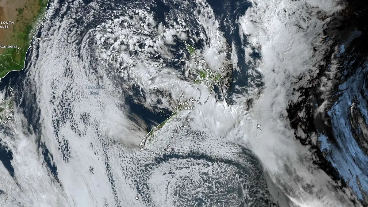
Image credit: JMA/Himawari-9, Zoom Earth, The Watchers. Acquired at 03:50 UTC on April 20, 2026
Heavy rain began lashing the Wellington region on Saturday, April 18, when intense thunderstorms produced up to 40 mm (1.6 inches) of rain within a single hour near Upper Hutt, prompting the evacuation of 24 homes and triggering flash flooding across multiple suburbs.
By Sunday and into Monday, rainfall had accumulated further across already saturated ground, with Wellington’s mayor reporting that 77 mm (3 inches) fell in one hour at a single location — a rate he described as truly tropical and extreme even by tropical benchmarks. The persistent multi-day event has pushed river levels sharply higher, caused widespread surface flooding, and triggered landslides across the greater Wellington region.
Wellington declared a state of emergency on Monday afternoon as flooding, swollen rivers, and landslides began cutting through infrastructure and disrupting transport across the region. A large landslide in the Kingston suburb blocked a residential street, leaving multiple homes isolated and forcing Fire and Emergency New Zealand to carry out evacuations.
The Wellington Region Emergency Management Office (WREMO) reported surface flooding across parts of the city, rising water levels along the Hutt River and Waiwhetū Stream, and debris blocking key routes — including State Highways 1, 2, and 58.
The Red Heavy Rain Warning for Wellington and the Hutt Valley, excluding Porirua, is valid from 14:00 LT Monday through 21:00 LT Tuesday, April 21. Additional rainfall totals of 100-150 mm (3.9-5.9 inches) are forecast for the Hutt Valley, with lower amounts elsewhere. Peak rainfall rates of 15-25 mm/h (0.6-1 inches/h) are expected, with localized intensities of 25-40 mm/h (1-1.6 inches/h) possible, particularly during thunderstorms.
For Wairarapa, the Red Heavy Rain Warning is in effect from 14:00 LT Monday through 00:00 LT Wednesday, April 22. Forecast totals include 80-120 mm (3.1-4.7 inches) across the region, with 200-280 mm (7.9-11 inches) expected over the ranges and coastal hills. Similar peak rainfall rates of 15-25 mm/h (0.6-1 inches/h) are forecast, with localized intensities of 25-40 mm/h (1-1.6 inches/h) possible in convective activity.
MetService warned residents in the affected areas to stay off the roads and out of any floodwaters, act without hesitation to self-evacuate if water begins to rise around them, and prepare for possible outages to both power and communications.
The National Emergency Management Agency (NEMA) and WREMO said that ground conditions are already saturated following persistent rainfall over the preceding days, increasing the likelihood of rapid runoff, river level rises, and slope instability. Flooding and landslides remain likely as additional rainfall accumulates over already weakened terrain.
WREMO advised residents in flood-prone and landslide-prone areas to consider relocating temporarily, warning of dangerous river conditions and the potential for roads to become impassable. Travel disruption and infrastructure impacts remain possible as rainfall continues.
The event is associated with a slow-moving low-pressure system affecting multiple regions across New Zealand. Orange Heavy Rain Warnings were in place for parts of northern Canterbury, while additional watches extended across Marlborough, Kapiti Coast, and areas further north as the system tracks across the country.
Thunderstorms with heavy rain and strong wind gusts affected northern regions earlier in the event, producing localized severe conditions. In the alpine areas of northern Canterbury, lowering freezing levels introduced the potential for snowfall over mountain passes.
The most intense rainfall is forecast to continue through Tuesday, April 21. A ridge of high pressure is forecast to influence the South Island from Wednesday, with improving conditions expected there first, while unsettled conditions persist longer over the North Island.
References:
1 Red Heavy Rain Warning – MetService – April 20, 2026
2 Wellington Region update – WREMO – April 20, 2026
3 Heavy rain advisory – NEMA – April 20, 2026
4 State of local emergency declared for Whanganui District, Ōhura Ward and Wellington Region – NEMA – April 20, 2026
5 Thunderstorms spark flash flooding in New Zealand capital Wellington – Reuters – April 18, 2026
I'm a dedicated researcher, journalist, and editor at The Watchers. With over 20 years of experience in the media industry, I specialize in hard science news, focusing on extreme weather, seismic and volcanic activity, space weather, and astronomy, including near-Earth objects and planetary defense strategies. You can reach me at teo /at/ watchers.news.
Commenting rules and guidelines
We value the thoughts and opinions of our readers and welcome healthy discussions on our website. In order to maintain a respectful and positive community, we ask that all commenters follow these rules.