
Red wind warning and widespread severe weather alerts issued as Cyclone Vaianu approaches North Island, New Zealand
Cyclone Vaianu is forecast to move south across New Zealand’s North Island on Sunday, April 12, 2026, bringing a multi-hazard threat, including damaging winds up to 140 km/h (87 mph), heavy rainfall, and coastal inundation risk. A Red Strong Wind Warning is in force for the Coromandel Peninsula and Great Barrier Island, with widespread Orange warnings and watches covering much of the North Island and upper South Island. Significant disruption to transport, power supply, and communities is expected.
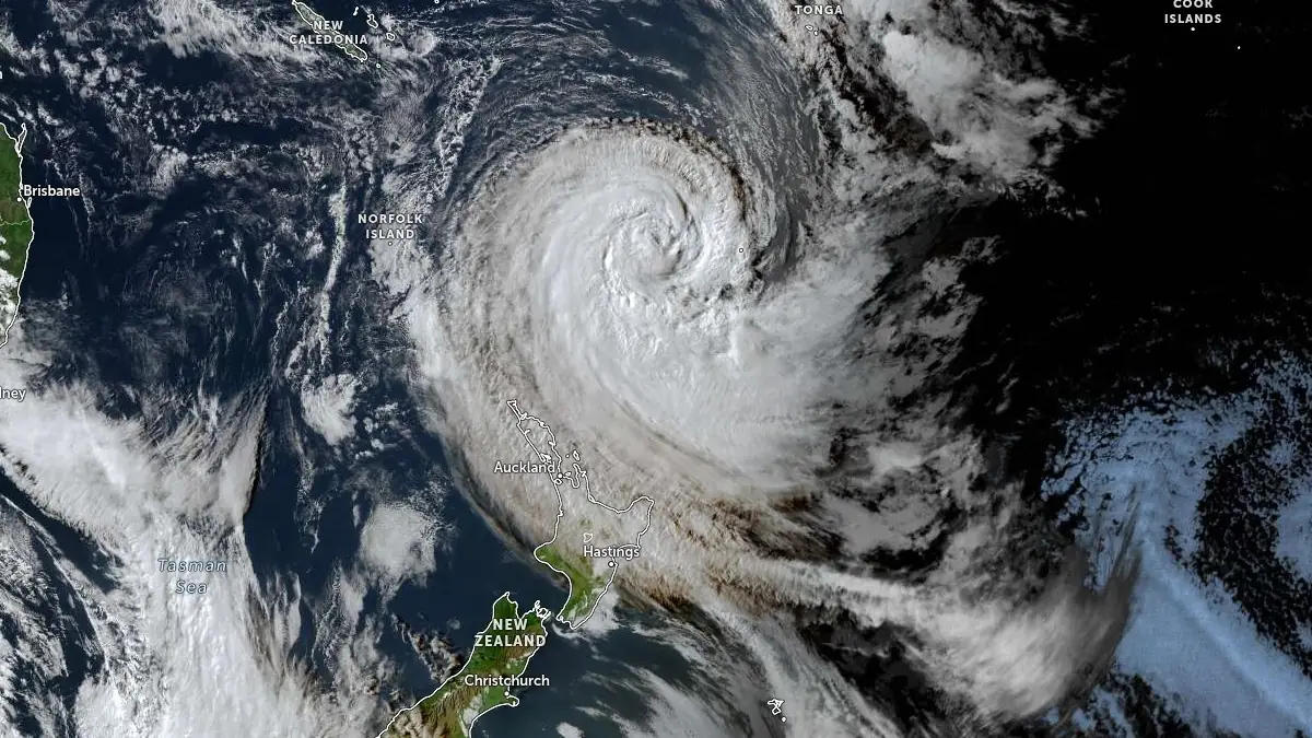
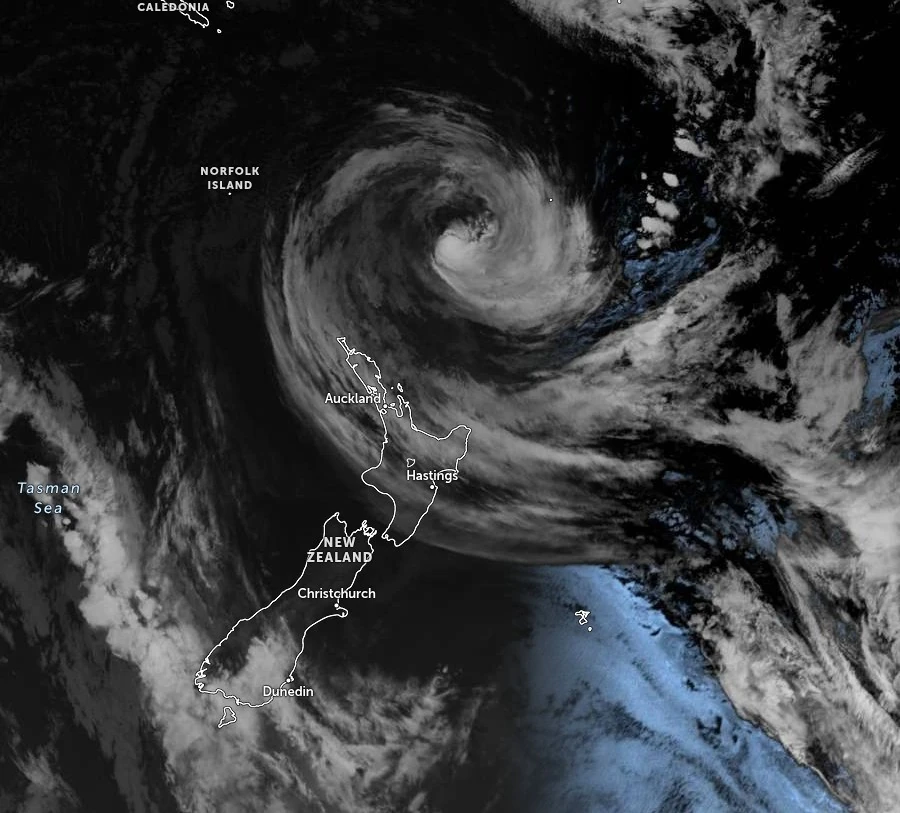
Satellite image of Cyclone Vaianu at 04:30 UTC on April 10, 2026. Credit: JMA/Himawari-9, Zoom Earth, The Watchers
Cyclone Vaianu is forecast to track southward across New Zealand’s North Island on Sunday, April 12, bringing damaging winds, heavy rainfall, coastal inundation, and hazardous marine conditions.
The system is transitioning from a tropical cyclone to a sub-tropical system, but retains a broad wind field and significant moisture content capable of producing widespread impacts.
The highest wind hazard is currently identified in the Coromandel Peninsula and Great Barrier Island, where a Red Strong Wind Warning is in force from 01:00 to 18:00 local time (LT) Sunday. Severe gale easterlies are forecast to shift to west to northwesterlies during the afternoon, with gusts reaching 140 km/h (87 mph).
Such conditions present a threat to life from airborne debris and falling trees, with destructive winds capable of causing widespread damage to roofs, power lines, and transport infrastructure.
Orange Strong Wind Warnings extend across Northland, Auckland, Waikato, Bay of Plenty, Gisborne/Tairāwhiti, Hawke’s Bay, and parts of the central and lower North Island regions.
Wind gusts are expected to range between 120 and 130 km/h (75-81 mph) in exposed areas, with several regions carrying a moderate to high probability of upgrade to Red warning status as the cyclone approaches and forecast confidence improves.
Heavy rainfall is expected to affect large parts of the North Island, with the most significant accumulations forecast over the Coromandel Peninsula, Bay of Plenty, and Gisborne/Tairāwhiti.
Rainfall totals of 150-180 mm (5.9-7.1 inches) are expected in elevated terrain, with peak intensities reaching 20–30 mm per hour. Lower elevations and coastal zones are forecast to receive between 70 and 100 mm (2.8–3.9 inches), sufficient to trigger rapid rises in streams and rivers.
The impacts are expected to be amplified by pre-existing soil saturation, increasing the likelihood of surface flooding, landslides, and slope instability. Transport corridors, particularly in hill country and coastal regions, are vulnerable to slips and debris flows, with isolated communities a credible outcome where road access is disrupted.
Coastal hazard conditions are expected to develop in parallel with the wind and rainfall impacts. Large swells and coastal inundation are forecast, particularly along eastern coastlines exposed to persistent onshore flow. Combined wave heights of 6–6.5 m (20–21 feet) are forecast along parts of the Wairarapa coast, coinciding with periods of high tide, increasing the risk of coastal flooding and erosion.
Forecast guidance indicates that the distribution of the most severe impacts remains sensitive to the cyclone’s track. MetService states that areas experiencing the strongest winds and heaviest rainfall may shift as forecast confidence improves.
A local state of emergency has been declared in Northland, reflecting concern over flooding, wind damage, and infrastructure disruption. Transport authorities have also implemented precautionary road closures in vulnerable areas, including sections of State Highway 35, and have warned of further closures on short notice due to slips and hazardous conditions.
New Zealand’s civil defense agency urged residents in affected regions to prepare ahead of Cyclone Vaianu’s arrival.
Secure or bring inside any items that could be picked up by strong winds, including outdoor furniture and trampolines, which should be turned upside down and firmly tied down, and remove loose debris such as branches and firewood, clear drains to reduce flooding risk, check on vulnerable neighbors, and prepare emergency plans, grab bags, and essential supplies in case evacuation becomes necessary, along with ensuring access to torches and a battery- or solar-powered radio to stay updated with official alerts.
Authorities are urging anyone whose life, health, or property is at risk to call 111, and to act immediately if rising water is observed, as floods and flash floods can develop rapidly without warning.
Landslides may occur without warning, particularly after prolonged rainfall, and residents are advised to move quickly out of their path if observed and avoid affected areas.
“Watch for warning signs like small slips or rockfalls, water flowing out of a slope, trees or fences that start to tilt or doors and window frames that start to stick,” said John Price, NEMA’s Director of Civil Defence Emergency Management. “Also, take care around trees which may become unstable and fall.”
During the peak of the event, civil defense recommends staying indoors, avoiding unnecessary travel, and remaining sheltered, as strong winds are capable of bringing down trees and power poles, damaging structures, and generating fast-moving debris.
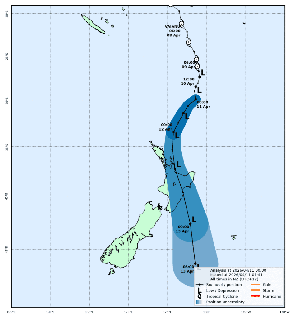
The event is expected to evolve rapidly through Sunday, with the peak impact window varying by region as the system progresses southward.
Strong Wind and Heavy Rain Watches extend into the lower North Island and upper South Island, indicating potential expansion of hazardous conditions beyond the currently warned areas.
MetService meteorologists are urging people to keep up to date with the latest forecasts, adjust plans as needed and be prepared to act, following all advice of local authorities.
Vaianu was reclassified as a sub-tropical system late Thursday night (LT). While this reflects the changing characteristics of the cyclone, Vaianu remains a powerful and active system.
“Over warm water, a tropical cyclone is round, neat, and its impacts are strongest at the center,” MetService said.
“As it moves south, it becomes less round (more comma-shaped), the center is less clear, and the strongest winds and rain happen further from the center. As the storm gets wider, strong winds can affect a much larger area, and it can produce intense rainfall over a wide area.”
References:
1 Warnings & Watches – MetService – Accessed 17:30 UTC on April 10, 2026
2 Get ready for Cyclone Vaianu now – before it arrives – NEMA – April 8, 2026
I'm a dedicated researcher, journalist, and editor at The Watchers. With over 20 years of experience in the media industry, I specialize in hard science news, focusing on extreme weather, seismic and volcanic activity, space weather, and astronomy, including near-Earth objects and planetary defense strategies. You can reach me at teo /at/ watchers.news.
Commenting rules and guidelines
We value the thoughts and opinions of our readers and welcome healthy discussions on our website. In order to maintain a respectful and positive community, we ask that all commenters follow these rules.