
Enhanced risk of severe thunderstorms issued for parts of the Northeast, Mid-Atlantic, and Lower Great Lakes on July 18
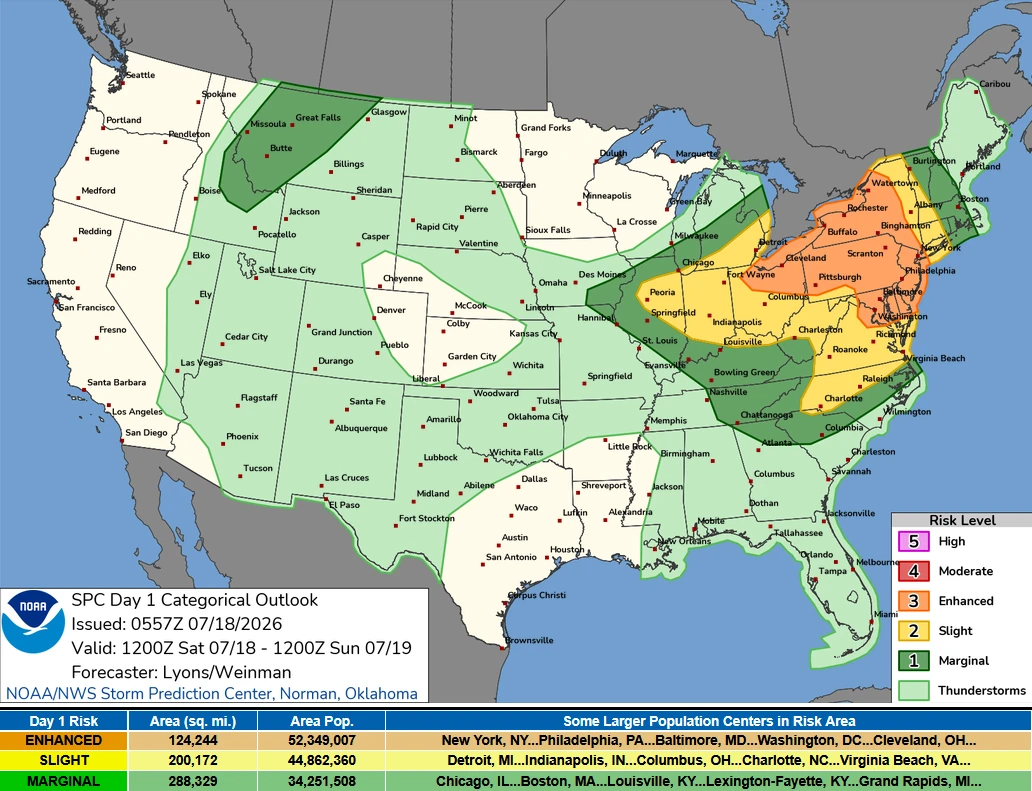
An enhanced risk of severe thunderstorms has been issued for portions of the Northeast, Mid-Atlantic, and Lower Great Lakes on Saturday, July 18, 2026, as an unusually strong upper-level storm system brings the threat of widespread damaging winds, large hail, and several tornadoes through the afternoon and evening.
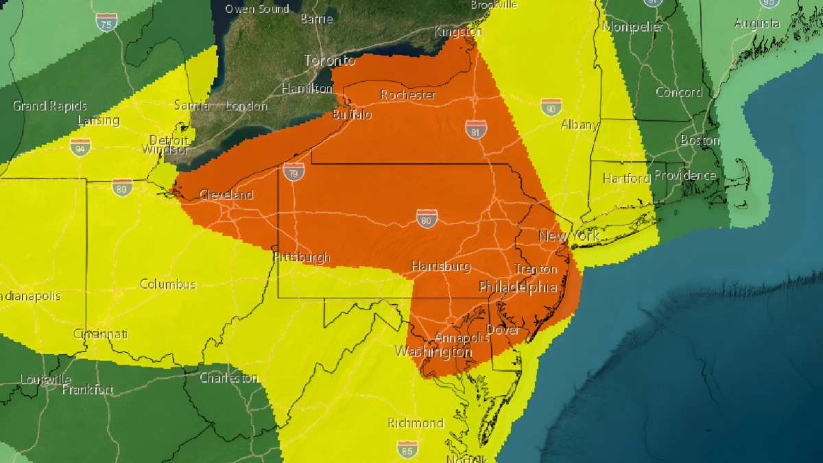
Image credit: NWS/SPC
An enhanced risk of severe thunderstorms has been issued for portions of the Lower Great Lakes, Mid-Atlantic, and Northeast on Saturday, July 18, as an unusually strong upper-level storm system sweeps across the northeastern United States.
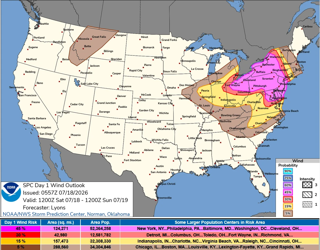
Widespread damaging winds, large hail, and several tornadoes are possible from Saturday afternoon into the evening, with some severe storms continuing overnight.
The Storm Prediction Center (SPC) places the greatest concern across parts of the Ohio Valley, Lower Great Lakes, Mid-Atlantic, and Northeast, where a combination of abundant moisture, strong atmospheric instability, and powerful wind shear is expected to create an environment favorable for widespread severe convection.
According to the SPC, an unseasonably strong upper-level trough will move from southern Ontario into the northeastern United States through early Sunday while strengthening.
A mid-level jet exceeding 111 km/h (69 mph) will overspread eastern Canada and the Northeast, helping deepen a surface low over the eastern St. Lawrence Valley.
At the same time, a warm front will lift northward across eastern New York and southern New England, while a cold front advances eastward from the Ohio Valley and Great Lakes. South of these boundaries, a very moist and unstable air mass will be in place, supporting the development of numerous severe thunderstorms.
Forecasters expect clusters of showers and thunderstorms to be ongoing early on Saturday across central Pennsylvania, southern New York, and eastern Ontario.
Storm evolution remains uncertain because several different forcing mechanisms are expected to be active simultaneously. Morning storms near the advancing warm front could quickly intensify again as instability increases, raising the threat of damaging wind gusts.
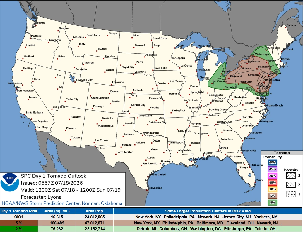
Deep-layer wind shear of 65–83 (40–51 mph) will also support supercell development, while favorable low-level wind fields could produce a couple of tornadoes, some of which may be strong, particularly across southeastern Pennsylvania, New Jersey, and southern New York.
Additional thunderstorms are expected to develop farther south along a pre-frontal convergence zone extending from southern Pennsylvania through eastern Maryland, northern Virginia, and into northern North Carolina. Environmental conditions will support both supercells and organized line segments.
The storms are forecast to move eastward toward the Delmarva Peninsula and the I-95 corridor during the afternoon.
Widespread damaging wind gusts are considered likely from northeastern Virginia through eastern Maryland into southeastern Pennsylvania and New Jersey, and forecasters indicate that wind probabilities could be increased further if confidence grows in a more organized line of storms.
Farther west, ahead of the advancing cold front, broken clusters of thunderstorms are expected from New York and Vermont westward into the Lower Great Lakes.
The strongest wind shear will be focused across upstate New York, northwestern Pennsylvania, and northeastern Ohio, where a few supercells may develop. These storms will pose a threat of damaging winds, isolated large hail, and tornadoes, especially near the surface low and along the warm frontal zone, where low-level wind shear will be strongest.
Outside the primary severe weather corridor, isolated severe thunderstorms are also possible across the northern Rockies, where monsoonal moisture, daytime heating, and modest wind shear may support isolated hail and localized severe wind gusts.
Along the northern Gulf Coast, a remnant mesoscale convective vortex may trigger scattered thunderstorms capable of producing sporadic damaging downbursts, although forecasters consider the severe threat there too limited to warrant formal severe wind probabilities.
References:
1 Day 1 Convective Outlook – NOAA/SPC – July 18, 2026

I am an Assistant Editor and Severe Weather & Science Journalist at The Watchers, specializing in real-time severe weather coverage, geophysical event reporting, and research-driven scientific analysis. You can reach me at rishav(at)watchers(.)news.

Commenting rules and guidelines
We value the thoughts and opinions of our readers and welcome healthy discussions on our website. In order to maintain a respectful and positive community, we ask that all commenters follow these rules.