
Two major earthquakes M7.2 and M7.5 strike Venezuela within 39 seconds – death toll exceeds 5 200
A rare earthquake doublet struck northern Venezuela on June 24, 2026, beginning with an M7.2 foreshock at 22:04 UTC (18:04 LT) and followed just 39 seconds later by a larger M7.5 mainshock at 22:05 UTC. The USGS reported depths of 20.3 km (12.6 miles) for the foreshock and 10 km (6.2 miles) for the mainshock. EMSC reported the foreshock as M7.1 at a depth of 10 km (6.2 miles) and the mainshock as M7.5 at a depth of 35 km (21.7 miles). The Pacific Tsunami Warning Center (PTWC) said evaluation of all available data indicates that a destructive tsunami was not generated.
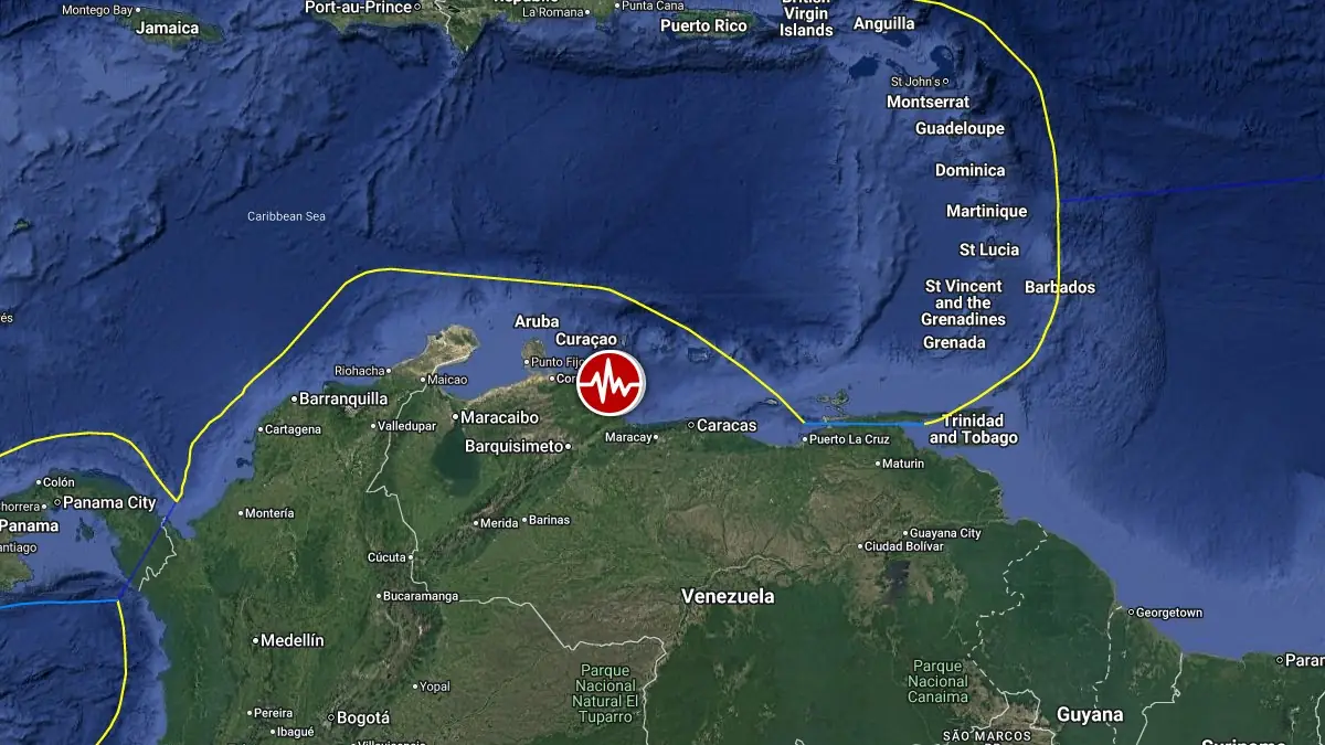
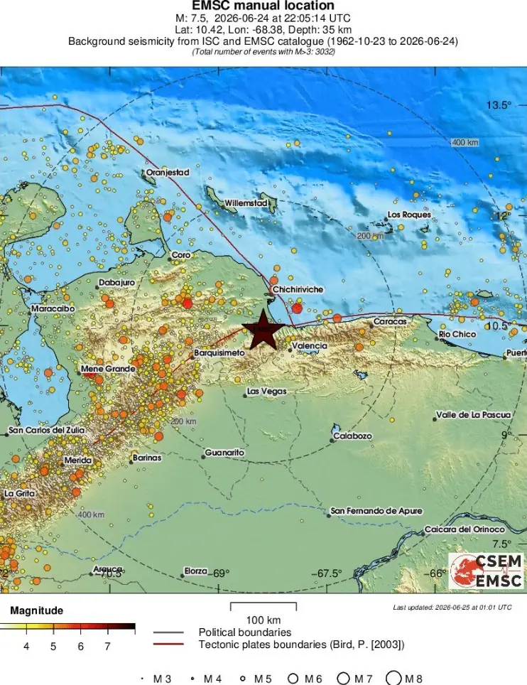
Epicenter of M7.5 earthquake in Carabobo, Venezuela on June 24, 2026. Credit: TW/SAM, Google
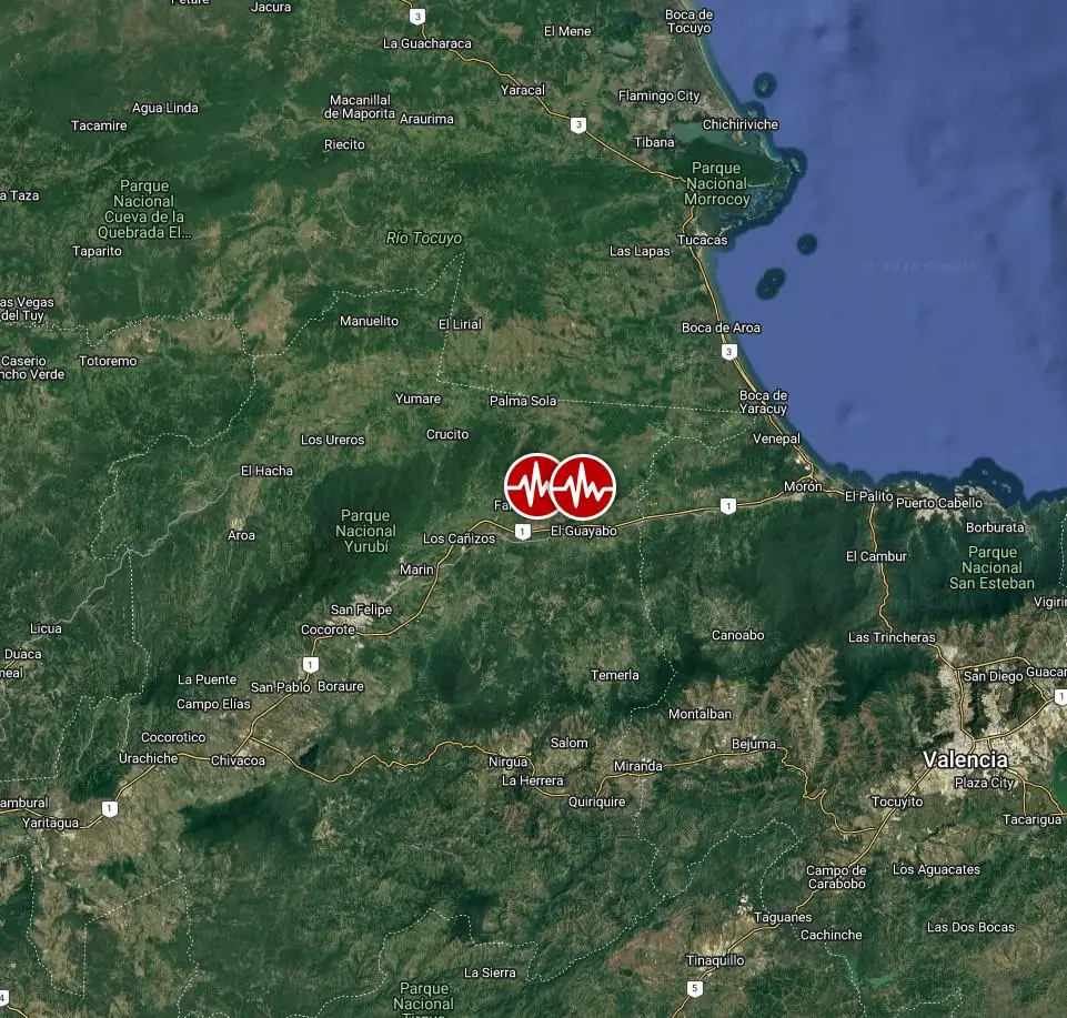
The earthquake sequence began with an M7.2 foreshock at 22:04 UTC, followed just 39 seconds later by a larger M7.5 mainshock at 22:05 UTC. Both earthquakes struck within a few kilometers of each other southeast of Yumare in northern Venezuela.
The M7.2 foreshock was located 23 km (15 miles) SE of Yumare (population 15 661) and 26 km (16 miles) ENE of San Felipe (population 206 270). The M7.5 mainshock occurred 39 seconds later, with its epicenter located 28 km (18 miles) SE of Yumare (population 15 661), 29 km (18 miles) NNW of Montalbán (population 29 451), 30 km (19 miles) W of Morón (population 68 084), and 31 km (20 miles) ENE of San Felipe (population 206 270).
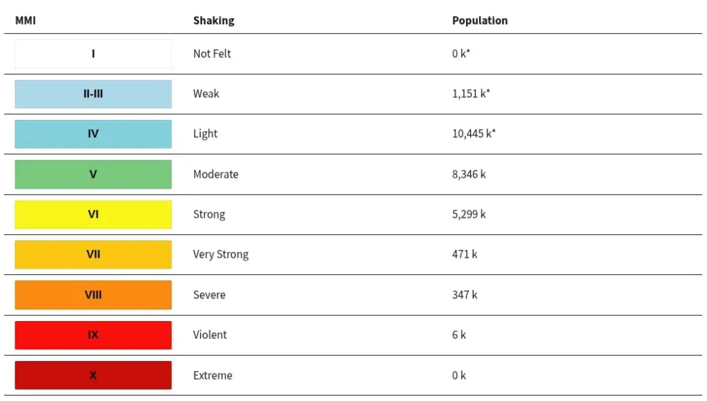
6 000 people are estimated to have felt violent shaking associated with the M7.5, 347 000 severe, 471 000 very strong, and 5.3 million strong.
Evaluation of all available data indicates that a destructive tsunami was not generated by either earthquake, according to the Pacific Tsunami Warning Center (PTWC).
The USGS issued Red PAGER alerts for both earthquakes, indicating high casualties and extensive damage are probable and that the disaster is likely widespread. Estimated economic losses are 1–4% of Venezuela’s GDP for the M7.5 mainshock and 0–7% for the M7.2 foreshock.
Overall, the population in the affected region resides in structures that are vulnerable to earthquake shaking, though resistant structures exist. The predominant vulnerable building types are unreinforced brick masonry and adobe block construction. Recent earthquakes in this area have caused secondary hazards such as tsunamis that might have contributed to losses.
Liquefaction and landsliding are expected to be significant for both earthquakes, with large areas and populations exposed to potential ground failure.
“Dozens of buildings have collapsed, and we are currently carrying out very intense rescue efforts to save as many lives as God allows us to save,” Venezuela’s acting President Delcy Rodríguez said at 05:00 UTC on June 25. Building collapses have been confirmed in Caracas, Trujillo, Carabobo, Aragua, Miranda, and La Guaira.
La Guaira, a coastal state in the north of the country near Caracas, is the most affected, with “dozens” of buildings collapsed, Rodríguez said. “We can say that La Guaira state is a true tragedy and has become a disaster zone.”
Latest figures show at least 32 people were killed, not including those from La Guaira state, and more than 700 were injured.
Rodríguez said the country’s main airport, Simón Bolívar International Airport, was closed after sustaining severe damage. Schools have been closed for several days.
A state of emergency has been declared, and rescue teams from the United States, Mexico, El Salvador, Qatar, and the Dominican Republic are expected to arrive in the country.
“Authorities, security forces, medical services, and civil protection are deployed across the entire country to address the situation,” Rodríguez said.
Today’s M7.5 earthquake southeast of Yumare, Venezuela, resulted from shallow right-lateral strike-slip faulting near the complex boundary between the Caribbean and South American plates, according to the USGS.
At the earthquake’s location, the Caribbean Plate moves eastward relative to the South American Plate at approximately 20 mm (0.8 inches) per year. This motion is primarily accommodated by a major system of right-lateral strike-slip faults across northern Venezuela.
The earthquake’s shallow depth of 10 km (6.2 miles), location and focal mechanism are consistent with rupture along the regional plate-boundary system, including the Boconó fault system.
The M7.5 earthquake was the larger event in a seismic doublet, occurring 39 seconds after an M7.2 earthquake. A seismic doublet consists of two earthquakes of similar magnitude occurring close together in time and location, and may reflect complex interaction between ruptures on nearby or connected fault segments.
Although earthquakes are commonly represented as points on maps, events of this magnitude involve slip across a broad fault area. Strike-slip earthquakes comparable to the June 24 event typically rupture an area of approximately 150 x 20 km (93 x 12 miles).
Northern Venezuela has a history of large and damaging earthquakes. However, only seven M6.0 or stronger earthquakes have occurred within 250 km (155 miles) of the June 24 earthquakes over the past century.
The region experienced another earthquake doublet in September 2025, when M6.2 and M6.3 earthquakes struck west-southwest of the 2026 events. That sequence caused at least 1 fatality, more than 110 injuries and extensive structural damage across Zulia and Lara states.
An M6.4 earthquake struck east-northeast of the June 2026 epicenters in September 2009, injuring 18 people and damaging buildings near Morón. An M6.0 earthquake in 1989 caused slight damage in the Valencia area, while an M6.1 earthquake affected the broader region in April 1975.
The most damaging modern earthquake in the surrounding region was the July 1967 M6.6 Caracas earthquake, with the epicenter approximately 131 km (81 miles) east of the June 2026 sequence. It caused about 240 fatalities, injured hundreds of people, collapsed multiple high-rise apartment buildings, and caused widespread destruction.
Across northern Venezuela and nearby offshore areas, five M7.0 or stronger earthquakes have occurred since 1900.
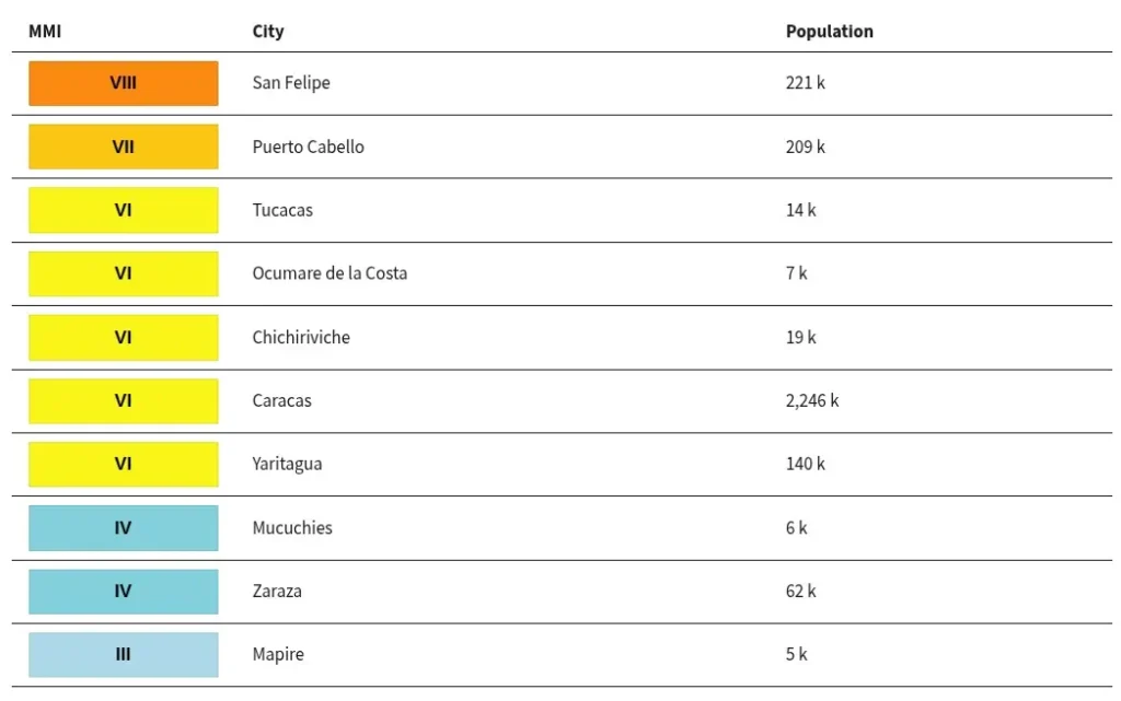
Estimated population exposure to earthquake shaking
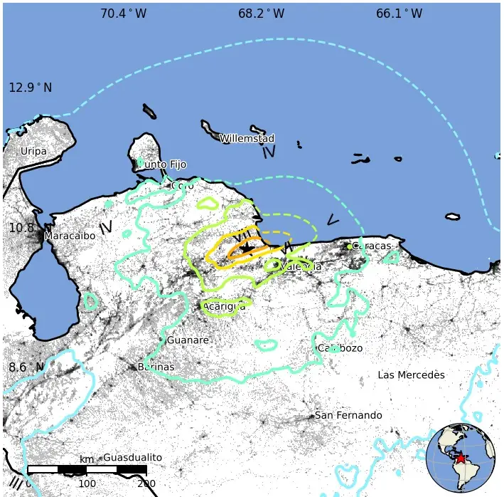
Selected cities exposed
Regional seismicity
Updates
12:00 UTC, June 25
President Rodríguez reported at least 164 deaths and 971 injuries. Rescue operations continue, and the toll is expected to continue increasing.
Rodríguez described La Guaira as a disaster zone, with dozens of buildings collapsed and people believed trapped. In Caracas, reports describe collapsed structures, debris-blocked streets, damaged utility infrastructure, and interruptions to power and mobile service.
Caracas Metro services and natural-gas service were suspended, schools were closed for several days, and some schools were designated as shelters and donation centers.
At least 30 aftershocks have been reported.
13:10 UTC, June 26
Venezuela’s government has raised the death toll from the June 24 M7.2–M7.5 earthquake doublet to 589, while revising the number of injured to 2 980. The figures remain provisional as emergency teams continue search-and-rescue operations in collapsed buildings.
Authorities reported 2 227 affected families and 250 structures affected or lost. La Guaira remains the worst-hit area, where at least 100 buildings, including high-rise apartments, collapsed, according to Reuters reporting.
Foreign urban-search-and-rescue teams and humanitarian assistance have begun arriving. Reuters reported deployments from Mexico, El Salvador, Spain, Colombia, Switzerland and Germany, while the UN said 25 search-and-rescue teams from 16 countries were assigned or en route to the response.
11:40 UTC, June 27
The death toll has risen to 920, and the number of injured people to 3 360. There are 172 people still believed to be trapped under the debris. More than 50 000 people are reported missing / unaccounted for.
National Assembly President Jorge Rodríguez said the earthquakes damaged 383 buildings, including 13 hospitals and 25 commercial centers, while 1 002 additional structures sustained varying degrees of damage. Authorities also reported 3 007 displaced people. Search-and-rescue operations remain focused on the hardest-hit areas, particularly La Guaira.
06:40 UTC, June 30
The official death toll has risen to 1 719, with 5 034 people injured and 15 866 left homeless. Citizen-run registration websites list about 45 000 people as unaccounted for, although authorities have not provided a confirmed number of people still trapped beneath debris.
Authorities said nearly 200 buildings had been completely flattened and several hundred more severely damaged. Search-and-rescue operations remain concentrated in La Guaira, where 15 shelters and 50 provisional camps have been established for affected residents.
09:25 UTC, July 6
The death toll has risen to 3 342 late July 5 and the number of injured people to 16 740. At least 31 000 people are still unaccounted for. 6 462 people were rescued alive.
The number of people left without housing now stands at 17 345. Officials reported 856 buildings affected and 190 collapsed.
Remote-sensing assessments remain substantially higher but measure broader building impacts differently. Copernicus imagery identified at least 606 destroyed and 448 damaged buildings in its mapped area, while a separate Microsoft AI assessment detected impacts at more than 10 000 structures.
09:41 UTC, July 8
The death toll from the June 24 Venezuela earthquake doublet has risen to at least 3 685, with 16 740 people injured, according to an official update released on July 7.
Authorities said 6 462 people have been rescued and 17 907 people have been left homeless. The figures remain provisional.
Venezuela has recorded 1 076 aftershocks since the June 24 sequence, according to the latest official update.
The IFRC said the Venezuelan Red Cross remains on the ground, supporting search-and-rescue operations, assisting injured people, and assessing urgent needs. IFRC has launched a 50 million Swiss franc emergency appeal to support the response through the Venezuelan Red Cross.
19:30 UTC, July 12
The official death toll from the June 24 earthquake doublet has risen to 4 490, while 16 740 people were injured, according to figures released by National Assembly President Jorge Rodríguez and incorporated into UN Situation Report No. 19. Authorities reported that 6 462 people had been rescued.
At least 17 907 people were left without housing. More than 80 temporary shelters were operating, with government figures indicating that approximately 16 700 people were accommodated in 87 camps. The UN humanitarian response is targeting about 1.3 million people, while UNICEF estimates that as many as 1.8 million people, including 680 000 children, require some form of humanitarian assistance. These figures represent different assessment and response-planning scopes and should not be treated as conflicting displacement totals.
Authorities reported damage to 856 assessed buildings, including 190 that collapsed or sustained structural failure. This official inspection-building count is substantially narrower than a satellite-based NASA assessment, indicating that approximately 58 870 buildings may have sustained damage across the broader affected area. The remote-sensing estimate includes structures with possible damage signatures that require ground verification.
The government said approximately 25 000 new homes would be required during reconstruction and identified about 584 000 m² (6.29 million ft²) of land for housing projects, primarily in Osma and Chuspa. Broader economic losses have been provisionally estimated at approximately USD 37 billion, but this remains an assessment rather than a finalized government damage account.
Search-and-rescue operations have largely transitioned to recovery, debris removal, temporary shelter, and humanitarian assistance. Health authorities and PAHO continue monitoring overcrowded shelters for respiratory, gastrointestinal, and vaccine-preventable diseases amid disrupted water, sanitation, and medical services.
No current consolidated official figure for people still missing has been released alongside the July 12 totals. On July 11, officials reported that 315 recovered victims remained unidentified.
15:45 UTC, July 20
The Venezuelan government raised the death toll from the June 24 earthquake doublet to 5 209 on July 19. The number of injured remained at 16 740, while approximately 18 000 people were still without housing. The toll continues to rise as recovery teams remove debris and recover bodies from collapsed buildings, particularly in La Guaira.
The emergency response has largely transitioned from search and rescue to body recovery, debris removal, temporary shelter and humanitarian assistance. Authorities have not released a current consolidated count of people still missing. The United Nations estimates that the number could approach 50 000, but this remains an estimate rather than a confirmed government total.
The latest detailed government inventory includes 856 damaged buildings, including 190 that collapsed completely, while hundreds of roads, bridges and other structures were also affected. At least 1 331 aftershocks had been recorded by July 17.
Humanitarian agencies continue supporting affected communities across the hardest-hit states. UNICEF estimates that 650 000 people, including 230 000 children, have been directly or indirectly affected through damage, displacement or loss of access to essential services. Health risks remain elevated in temporary camps because of overcrowding, disrupted water and sanitation services and reduced access to routine healthcare.
References:
1 M7.5 earthquake, Carabobo, Venezuela – USGS – June 24, 2026
2 M7.2 earthquake, Yaracuy, Venezuela – USGS – June 24, 2026
3 M7.5 earthquake, Carabobo, Venezuela – EMSC – June 24, 2026
4 M7.1 earthquake, Yaracuy, Venezuela – EMSC – June 24, 2026
5 Pacific Tsunami Warning Center (PTWC) tsunami message No. 3 – PTWC – June 24, 2026
I'm a dedicated researcher, journalist, and editor at The Watchers. With over 20 years of experience in the media industry, I specialize in hard science news, focusing on extreme weather, seismic and volcanic activity, space weather, and astronomy, including near-Earth objects and planetary defense strategies. You can reach me at teo /at/ watchers.news.
Missing-person reports exceed 35 000 as death toll from Venezuela earthquake doublet rises to 164
By Rishav Kothari
Thursday, June 25, 2026 17:45 UTC
Warning from God to avoid death by strong earthquakes more mag 7 earthquake tsunami volcano in Europe in Asia in Africa in Pacific Ocean in North and South America non-Muslims to convert to Islam immediately June 25,2026.
Such a high impact on lives. Noting USGS forecast.
Doublet indeed.
Seeing the Euler-stress pattern suggestion, per ECDO framework hypothesis?
Antipodal point involvement. Solstice-associative- certainly a data-point.
Look at that pan-Pacific action and sequence starting a couple of weeks back, east-Africa felt the stress, Mediterranean usual hyper-mobility zone trampolining, primed Monte Nuevo noticed.
Resonant node(s).
Thoughts and prayers to prevail, for the many, many lives affected.