
EF1 tornado confirmed in northwest San Antonio, life-threatening flash flood threat continues across Texas
The National Weather Service (NWS) confirmed a preliminary EF1 tornado in northwest San Antonio, Texas, after surveying damage along a 6.4 km (4 miles) path across Bexar County on July 15, 2026. The tornado produced estimated peak winds of 161 km/h (100 mph), while additional thunderstorms maintained a life-threatening flash flood threat across parts of south-central and western Texas through July 16.
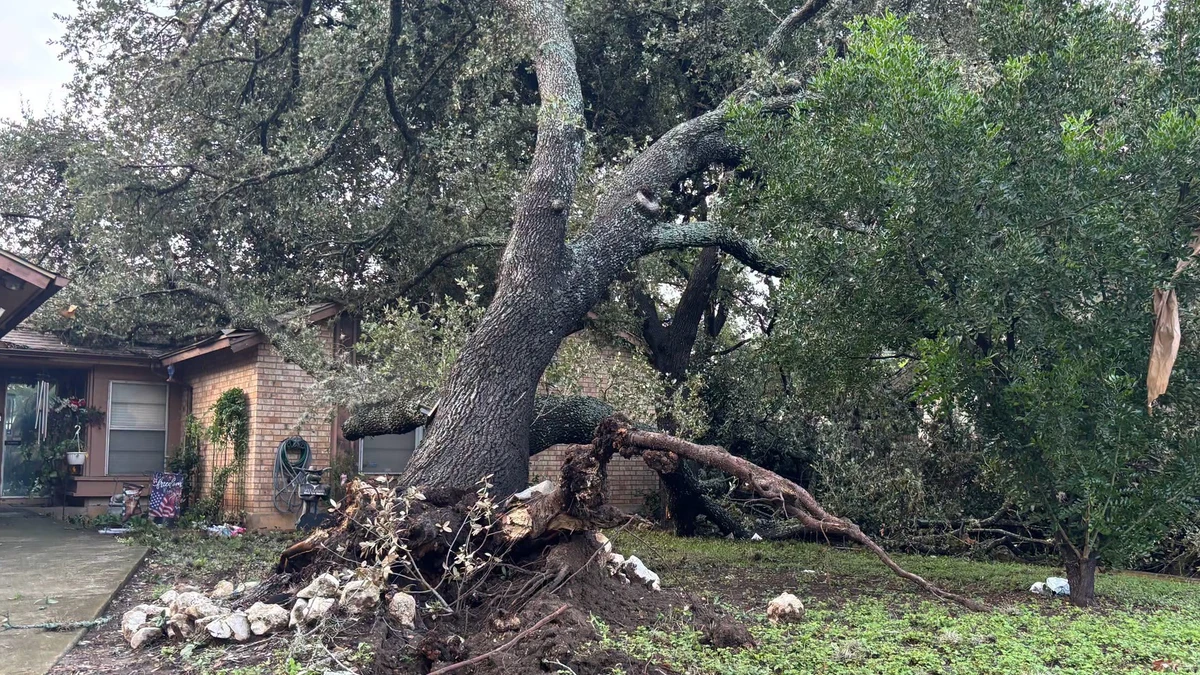
Storm-damaged tree in San Antonio following severe weather on July 15, 2026. Credit: CPS Energy
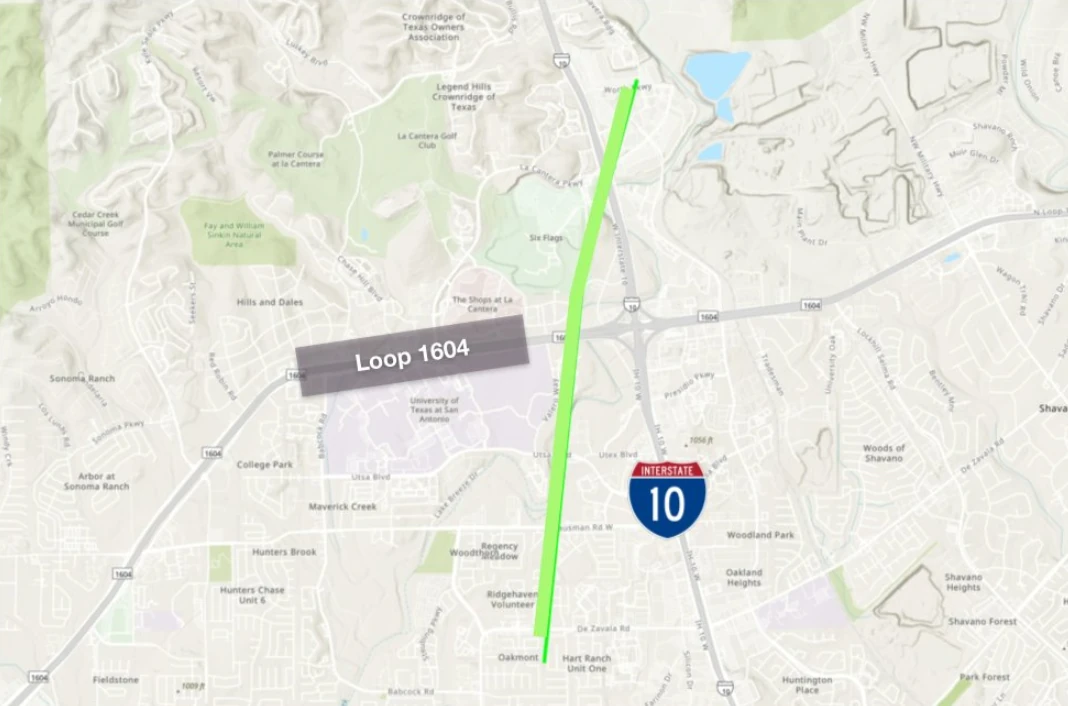
The National Weather Service (NWS) confirmed a preliminary EF1 tornado in northwest San Antonio, after surveying damage produced on July 15. The tornado touched down at approximately 12:44 UTC (07:44 LT), remained on the ground for about eight minutes, and produced estimated peak winds of 161 km/h (100 mph).
It began approximately 3 km (2 miles) southwest of the Interstate 10–Loop 1604 interchange and moved northeast for about 6.4 km (4 miles). The tornado then crossed Interstate 10 before dissipating just north of The Rim at approximately 12:52 UTC (07:52 LT).
Damage was reported near the University of Texas at San Antonio, The Rim, Camp Bullis, Crown Ridge, and the Dominion. A large section of the roof was torn from the Oasis Apartments on UTSA Boulevard, affecting three fourth-floor units, while trees, storefronts, signs, and electrical infrastructure were also damaged. No injuries were reported.
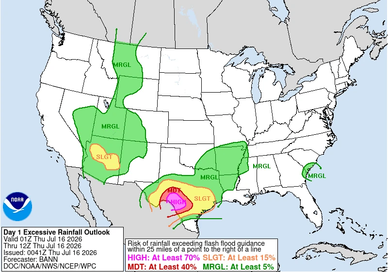
A Tornado Warning covering parts of Bexar, Comal, and Kendall counties remained in effect until 08:30 LT as the circulation moved northward. The tornado occurred during several days of severe weather and flooding across Texas, with a High Risk, level 4/4, of excessive rainfall in effect for parts of the Edwards Plateau, central Rio Grande Valley, and Hill Country until 12:00 UTC on July 16, followed by a Moderate Risk through 12:00 UTC on July 17.
No injuries were reported.
“Many of our neighborhoods, including the areas around UTSA, the Rim, Camp Bullis, Crown Ridge, Hills and Dales, and the Dominion, experienced significant damage as a tornado and severe weather moved through our community,” Councilwoman for District 8 Ivalis Meza Gonzalez said.
“Our crews continue working to restore power following today’s severe weather. As of 20:30 LT, 18 active outages are affecting approximately 310 customers across our service area, with 77 of those customers located near the Tanglewood Ridge and Hart Ranch neighborhoods on the Northwest Side,” CPS Energy said.
Damage assessments remained underway on July 16. Flash flood, severe thunderstorm and tornado warnings were in effect for parts of the NWS Austin/San Antonio forecast area early that day.
The Weather Prediction Center (WPC) maintained a High Risk, level 4/4, of excessive rainfall for portions of the Edwards Plateau, central Rio Grande Valley, and Texas Hill Country from 01:00 to 12:00 UTC on July 16. WPC said western Texas would remain the focus for heavy to excessive rainfall during the overnight and early morning hours.
Two circulation centers were supporting the continuing rainfall: one over the Hill Country and another between the Davis Mountains and the Edwards Plateau. High-resolution guidance showed increased probabilities of flash-flood guidance being exceeded, including a signal for rainfall approaching a 100-year average recurrence interval within parts of the High Risk area.
Parts of the Hill Country west of San Antonio had already received 254 to 406 mm (10 to 16 inches) of rain, according to WPC. An additional 102 to 203 mm (4 to 8 inches), with locally higher totals, was possible through early July 16.
The agency warned that significant to catastrophic flash flooding remains likely in the hardest-hit areas, urging residents to closely monitor forecasts and heed all warnings from local officials, particularly those living in flood-prone locations.
Although the threat is forecast to gradually diminish, heavy rainfall is expected to continue beyond Thursday. The WPC has issued a Moderate Risk (Level 3/4) of excessive rainfall for July 16-17 across portions of the Edwards Plateau, central Rio Grande Valley, and Hill Country.
Saturated soils and ongoing flooding will leave the region highly vulnerable to additional flash flooding from even modest rainfall totals.
A Flood Watch remains in effect for parts of the Hill Country, I-35 corridor, southern Edwards Plateau, and Rio Grande Plains through the evening of July 16.
The continuing threat followed high-water rescues, road closures, and shelter operations across parts of south-central Texas on July 14, when heavy rainfall produced flash flooding west of San Antonio.

I am an Assistant Editor and Severe Weather & Science Journalist at The Watchers, specializing in real-time severe weather coverage, geophysical event reporting, and research-driven scientific analysis. You can reach me at rishav(at)watchers(.)news.

Commenting rules and guidelines
We value the thoughts and opinions of our readers and welcome healthy discussions on our website. In order to maintain a respectful and positive community, we ask that all commenters follow these rules.