
Tropical Storm Arthur forms off the coast of Texas, flooding claims life of a 15-year-old boy
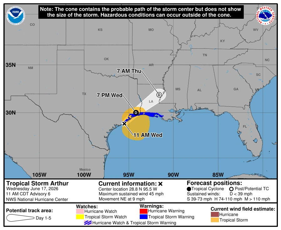
Tropical Storm Arthur formed about 100 km (60 miles) east-northeast of Port O’Connor, Texas on June 17, 2026 and is forecast to move northeastward along the Gulf Coast before tracking inland over southwestern Louisiana.
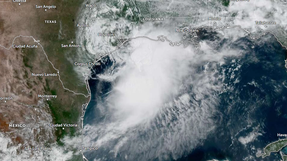
Satellite image of Tropical Storm Arthur at 16:50 UTC on June 17, 2026. Credit: NOAA/GOES-East, Zoom Earth, The Watchers
Tropical Storm Arthur formed near the coast of Texas on June 17 as the first named storm of 2026 Atlantic hurricane season.
The National Hurricane Center (NHC) warned that life-threatening flooding is expected across parts of the southeastern United States as the storm moves northeastward along the Gulf Coast.
The storm was located about 100 km (60 miles) east-northeast of Port O’Connor, Texas, and 265 km (165 miles) west-southwest of Lake Charles, Louisiana, at 16:30 UTC (11:30 CDT) on June 17, moving northeast at 15 km/h (9 mph). 1-minute maximum sustained winds were 75 km/h (45 mph), and the minimum central pressure was 999 hPa.
Arthur is forecast to accelerate and move along the Texas coast before tracking inland over southwestern Louisiana later on June 17. Tropical-storm-force winds extend up to 280 km (175 miles) from the center.
A NOAA buoy 42035 east of Galveston reported sustained winds of 72 km/h (45 mph) and a gust of 83 km/h (52 mph).
A Tropical Storm Warning is now in effect from Sargent, Texas, to Morgan City, Louisiana.
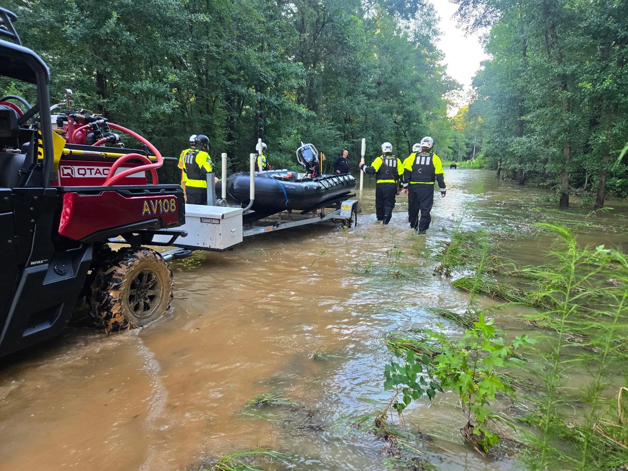
A 15-year-old boy lost his life after drowning in floodwaters in Magnolia, Texas, on June 16 due to flooding triggered by heavy rainfall from potential tropical cyclone one, which later strengthened into Tropical Storm Arthur.
Multiple agencies, including the Montgomery County Sheriff’s Office (MCSO) and the Magnolia Fire Department, responded to the incident at a flooded retention pond near the 30000 block of Turriff Circle in Magnolia at around 18:00 local time.
“Preliminary information indicates a group of teenagers was playing near a construction roadway and adjacent retention pond when a 15-year-old entered the water,” MCSO said. “The depth of the water quickly exceeded the juvenile’s height, and he went under and did not resurface. A 911 call was placed immediately by others at the scene.”
Heavy rainfall and flash flooding remain the main threats due to Arthur. The storm is forecast to drop 125–250 mm (5–10 inches) of rain, with isolated totals near 500 mm (20 inches), through early June 19.
The highest totals are expected from the Mid and Upper Texas coast east-northeastward into southern and central Louisiana, Mississippi, Alabama, western Georgia, and the Florida Panhandle
Potentially life-threatening flash flooding and urban flooding are likely through June 19 across southern Louisiana, southern Mississippi, southern Alabama, southwestern Georgia, and the Florida Panhandle. Flooding is also possible near the Upper Texas coast.
Minor to moderate coastal flooding is expected along parts of the Upper Texas and Louisiana coasts. Storm surge could raise water levels by 0.6 to 1.2 m (2 to 4 feet) above ground level from Port Bolivar, Texas, to Morgan City, Louisiana, depending on local tide conditions.
Swells generated by Arthur are expected to create life-threatening surf and rip current conditions along the northwestern Gulf Coast during the next several days. A couple of tornadoes are also possible through Thursday from the Upper Texas Coast into southern Louisiana, Mississippi, Alabama, and the western Florida Panhandle.
Arthur remains a strongly sheared tropical cyclone. Most of its thunderstorms are located east of the center. Tropical-storm-force winds are mainly confined to the eastern side of the circulation and are occurring mostly over offshore waters.
Arthur is forecast to maintain its intensity while over water and weaken after moving inland.
NHC forecasts the storm will open into a trough and dissipate before the end of the 24-hour forecast period. Forecasters are also monitoring the possibility of low-pressure development over the western Atlantic later this week from remnant energy associated with Arthur.
References:
1 Tropical Storm Arthur Discussion Number 5 – NOAA/NHC – June 17, 2026
2 Tropical Storm Arthur Special Advisory Number 6 – NOAA/NHC – June 17, 2026

I am an Assistant Editor and Severe Weather & Science Journalist at The Watchers, specializing in real-time severe weather coverage, geophysical event reporting, and research-driven scientific analysis. You can reach me at rishav(at)watchers(.)news.
Commenting rules and guidelines
We value the thoughts and opinions of our readers and welcome healthy discussions on our website. In order to maintain a respectful and positive community, we ask that all commenters follow these rules.