
Tropical Storm Bertha makes landfall in St Bernard Parish, Louisiana, heads toward upper Texas coast
Tropical Storm Bertha made landfall at approximately in St. Bernard Parish, Louisiana at approximately 13:50 CDT (18:50 UTC)on July 22, 2026, with maximum sustained winds of 72 km/h (45 mph). Storm surge of up to 1 m (3 feet), rainfall totals of 25 to 100 mm (1 to 4 inches) with isolated amounts reaching 150 mm (6 inches), and isolated flash flooding remain possible across portions of the central and western Gulf Coast through July 24.
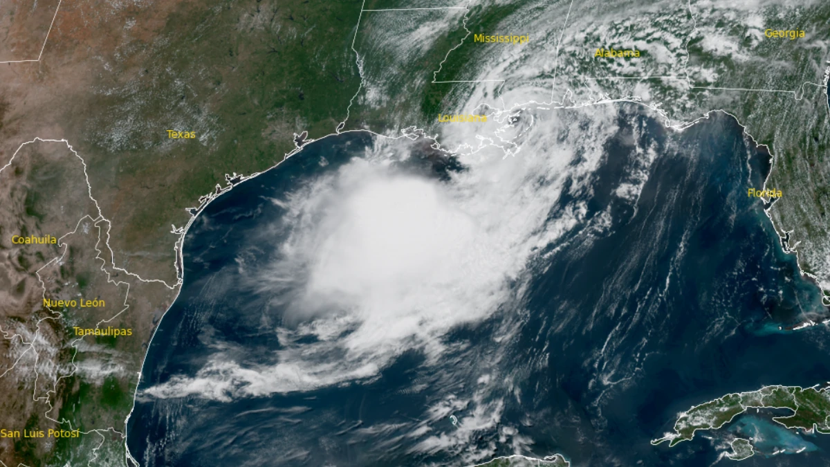
Satellite image of tropical storm Bertha at 18:20 UTC on July 22, 2026. Credit: NOAA/GOES-19, RAMMB/CIRA, The Watchers.
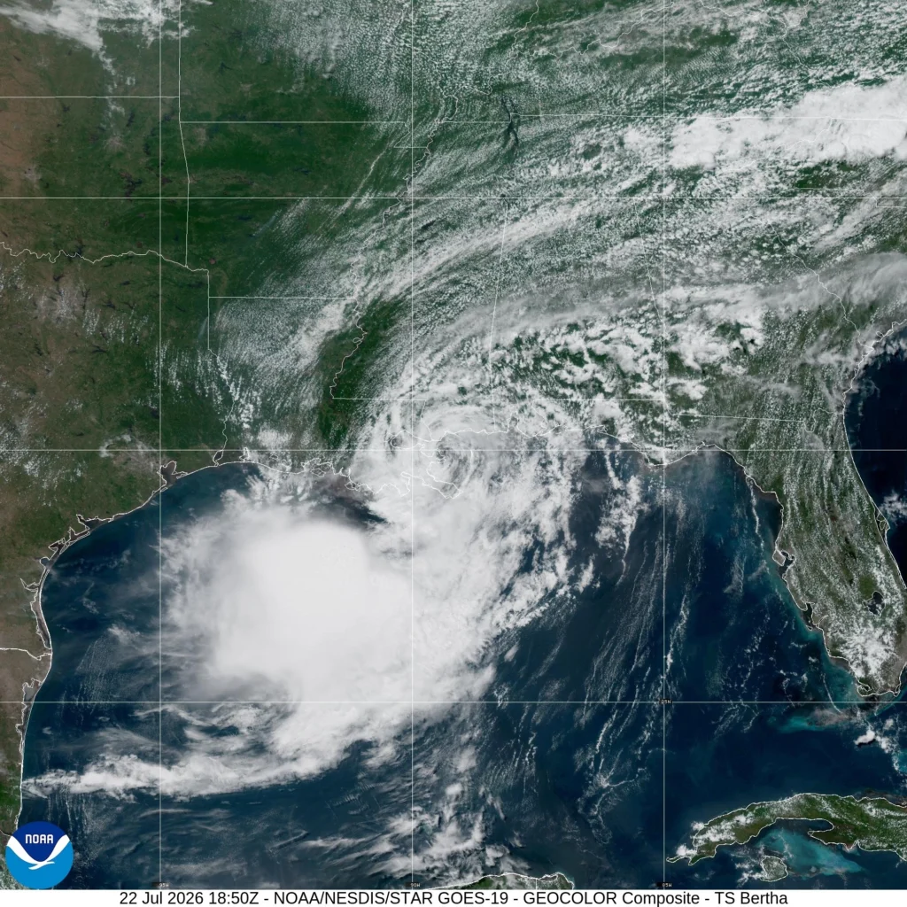
Tropical Storm Bertha made landfall in St Bernard Parish, Louisiana on July 22, with maximum 1-minute sustained winds of 72 km/h (45 mph).
“Satellite images indicate that the center of Tropical Storm Bertha had made landfall near the Biloxi Wildlife Management Area in St Bernard Paris, Louisiana,” the National Hurricane Center (NHC) reported in an update issued at 14:00 CDT on July 22.
It was located approximately 72 km (45 miles) southwest of Biloxi, Mississippi, and 65 km (40 miles) east of New Orleans, Louisiana.
The system was moving toward the west-northwest at 11 km/h (7 mph) with an estimated minimum central pressure of 1 000 hPa. Tropical-storm-force winds extended outward up to 165 km (105 miles) from the center.
Earlier, Bertha had weakened slightly in the afternoon as its center approached the southeastern Louisiana coast while battling strong vertical wind shear.
The NHC said the storm was expected to move near or along the Louisiana and upper Texas coasts through July 23 before tracking inland across Texas, with tropical storm conditions, coastal flooding and isolated flash flooding remaining possible across portions of the northern Gulf Coast.
Dauphin Island, Alabama, reported a sustained wind of 36 mph (58 km/h) and a gust to 41 mph (66 km/h), the NHC reported.
Earlier Wednesday morning, the NHC noted that Bertha’s satellite presentation had deteriorated significantly as strong deep-layer northeasterly wind shear displaced nearly all deep convection southwest of the exposed low-level center.
However, reconnaissance data showed little change in central pressure, prompting forecasters to initially maintain the storm’s intensity while awaiting additional aircraft and scatterometer observations.
Forecasters expect Bertha to resume a more westward motion with increasing forward speed. The official forecast takes the center near or along the Louisiana coast through July 23 before reaching the upper Texas coast by the evening or night.
It will then moving farther inland across Texas on July 24. Continued interaction with land and persistent wind shear should cause gradual weakening, with Bertha forecast to become a post-tropical remnant low by July 24 before dissipating.
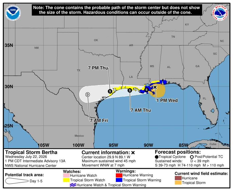
A Tropical Storm Warning remained in effect from the Alabama/Florida border westward to Morgan City, Louisiana, including metropolitan New Orleans and Lake Pontchartrain.
A Tropical Storm Watch remained in effect west of Morgan City to Sargent, Texas, as well as for Lake Maurepas. Meanwhile the warning east of the Alabama/Florida border was discontinued.
Tropical storm conditions were expected to continue spreading across portions of the northern Gulf Coast within the warning area, while tropical storm conditions remained possible across the watch area in Louisiana through the night of July 22, and along the upper Texas coast by July 23
Storm surge up to 1 m (1 to 3 feet) above ground level could inundate normally dry coastal areas from the Alabama/Florida border westward to Port Bolivar, Texas, including Lake Pontchartrain, depending on the timing of the surge relative to the tidal cycle.
Bertha is forecast to produce 25 to 100 mm (1 to 4 inches) of rainfall, with isolated totals up to 150 mm (6 inches) through July 23 across the central and western Gulf Coast from northwest Florida to southern Texas. The rainfall could trigger isolated flash flooding, particularly in urban areas.
Swells generated by the storm are also expected to create dangerous surf and life-threatening rip currents along the northern Gulf Coast.
Isolated flash flooding remains possible through July 24 morning from northwest Florida westward to southern Texas, while a Coastal Flood Warning remains in effect for portions of the Mississippi and Louisiana coastlines where moderate coastal flooding is expected.
References:
1 Tropical Storm Bertha Intermediate Advisory Number 13A – NOAA/NHC – July 22, 2026
2 Tropical Storm Bertha Discussion Number 13 – NOAA/NHC – July 22, 2026
3 Tropical Storm Bertha Tropical Cyclone Update – NOAA/NHC/X – July 22, 2026

I am an Assistant Editor and Severe Weather & Science Journalist at The Watchers, specializing in real-time severe weather coverage, geophysical event reporting, and research-driven scientific analysis. You can reach me at rishav(at)watchers(.)news.

Commenting rules and guidelines
We value the thoughts and opinions of our readers and welcome healthy discussions on our website. In order to maintain a respectful and positive community, we ask that all commenters follow these rules.