
Nueces River reaches major flood stage at Cotulla, major flooding forecast at Tilden, Texas
The Nueces River reached major flood stage at Cotulla late on July 20, 2026 as high river stages progressed through the Nueces–Frio system. The National Weather Service (NWS) forecast the Frio River at Tilden to crest at 8.5 m (28 feet) in major flood stage early July 22.
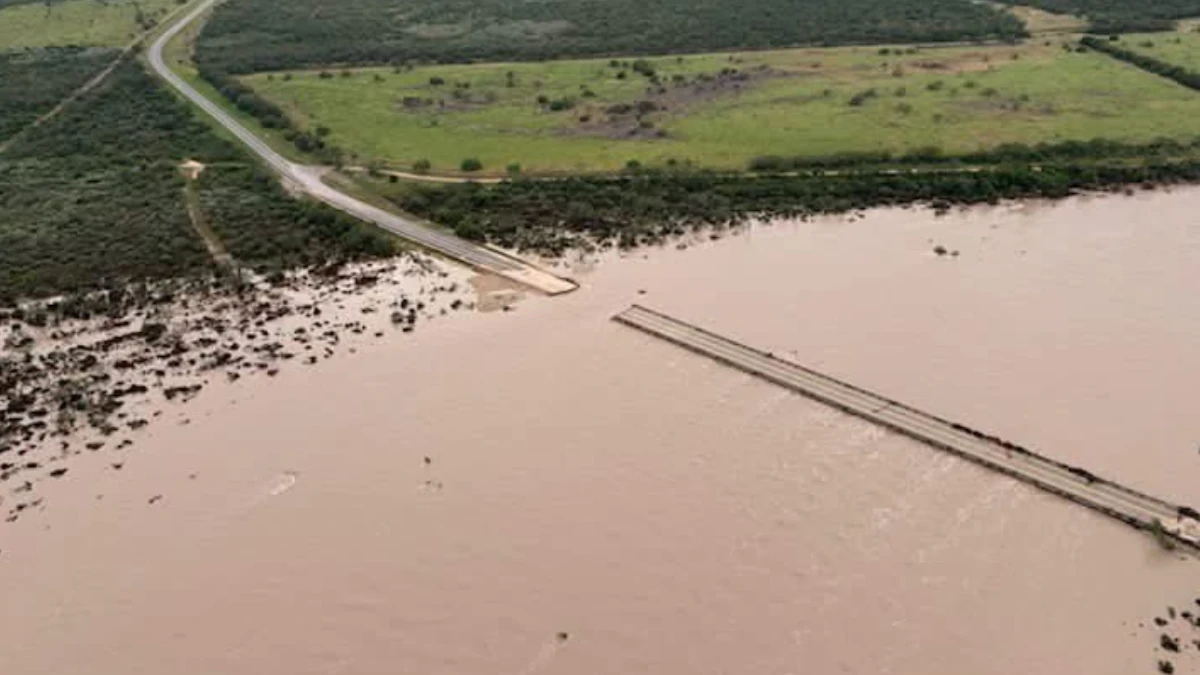
Bridge collapse due to river flooding in Uvalde County Texas July 17, 2026. Credit: Texas DOT
NWS Corpus Christi reported early July 21 that the Nueces River at Cotulla had reached major flood stage. A Flood Statement issued at 20:02 CDT (01:02 UTC on July 21) reported a stage of 4.42 m (14.5 feet) at 19:00 CDT (00:00 UTC on July 21), shortly before the river crossed the 4.57 m (15-foot) flood threshold.
The Nueces River was forecast to reach an initial crest of 7.01 m (23 feet) early July 22, fall to 6.74 m (22.1 feet), and begin rising again on July 23. NWS projected a second crest of 7.07 m (23.2 feet) on July 24, after which the river was expected to remain above flood stage beyond the displayed forecast period.
The expected Cotulla crest is comparable in stage to the 7 m (23 feet) crest recorded on June 16, 1981, during a severe multi-day flooding episode that struck Texas and spread into the Midwest and East Coast.
The event was part of a stormy stretch that triggered major flooding in Great Bend, Kansas on June 15, 1981, forcing widespread evacuations in what was described as the worst flooding there in 16 years. The relentless rain and accompanying tornadoes across the central and eastern US that weekend caused at least 20 deaths nationwide.
The 1981 crest remains a key historical benchmark for the Cotulla gauge for over four decades now.
On the Frio River at Tilden, NWS reported a stage of 3.57 m (11.7 feet) at 20:15 CDT on July 20 (01:15 UTC on July 21), just below the bankfull level of 3.66 m (12 feet). The river was forecast to cross its 6.71 m (22-foot) flood stage and crest at 8.50 m (27.9 feet) early July 22 before falling below flood stage late on July 24.
The NWS stage-impact statement for Tilden says that at 8.23 m (27 feet), numerous residences and businesses flood, people vulnerable to flooding require evacuation, and most roads near the river become flooded and dangerous.
The forecast crest at Tilden is comparable in stage to a crest of 8.53 m (28 feet) recorded on September 1, 1919. The Flood Warning remains in effect until late July 24, with the river forecast to fall below flood stage late that morning.
The Nueces River near Asherton was at 9.24 m (30.3 feet) at 19:30 CDT on July 20 (00:30 UTC on July 21) and was forecast to crest at 9.57 m (31.4 feet) early in the afternoon of July 21, approaching the flood of record.
At 9.45 m (31 feet) near Asherton, the official stage-impact statement says the Nueces River and Turkey Creek spread to approximately 2.4 km (1.5 miles) wide south and west of Crystal City. Farm-to-Market Road 190 floods for more than 1.6 km (1 mile), Highway 85 becomes impassable, and livestock should be removed from the floodplain. These are stage-associated impacts and do not independently confirm the operational status of each road.
The Frio River near Derby was experiencing moderate flooding on the evening of July 20, with the NWS reporting a stage of 3.05 m (10 feet). The official stage-impact statement says flooding at 2.13 m (7 feet) closes Farm-to-Market Road 1581 near Derby; independent confirmation of the road’s operational status was not identified in the authority products reviewed.
Taken together, the upstream observations and downstream forecasts documented high river stages across the Nueces–Frio system. No verified fatalities, injuries, rescues, property-loss totals, or confirmed evacuations at Cotulla or Tilden were identified in the authority products reviewed for this corrected draft.
NWS advised motorists not to drive around barricades or enter flooded roads and urged people near the rivers to remain cautious around riverbanks.
References:
1 Nueces and Frio River Flooding – NWS – July 20, 2026
2 Flood Statement – NWS – July 20, 2026

I am an Assistant Editor and Severe Weather & Science Journalist at The Watchers, specializing in real-time severe weather coverage, geophysical event reporting, and research-driven scientific analysis. You can reach me at rishav(at)watchers(.)news.

Commenting rules and guidelines
We value the thoughts and opinions of our readers and welcome healthy discussions on our website. In order to maintain a respectful and positive community, we ask that all commenters follow these rules.