
Extreme heat alerts cover portions of 31 U.S. states, heat index up to 46°C (115°F)
Extreme Heat Warnings, Extreme Heat Watches, and Heat Advisories are in effect across 31 U.S. states after the National Weather Service (NWS) issued a series of heat alerts on June 29, 2026. Peak heat index values are forecast to reach 46°C (115°F), with dangerous heat and humidity expected to persist into early July across parts of the Midwest, Northeast, Southeast, and central United States.
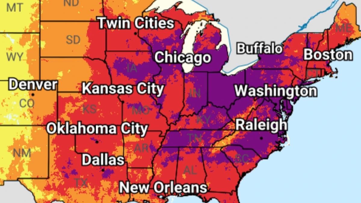
Image credit: NWS/WPC
Multiple Extreme Heat Warnings, Extreme Heat Watches, and Heat Advisories remain in effect across large parts of the central, Midwest, Northeast, and Southeast United States as of June 29.
The alerts cover areas where prolonged dangerous heat and high humidity are expected to produce hazardous conditions over the coming days, with peak heat index values reaching 46°C (115°F) in some locations.
North Dakota
Southeastern North Dakota, including Cass and Richland counties, remains under a Heat Advisory from 12:00 to 20:00 CDT on June 29.
Heat index values are forecast to reach 41°C (105°F), affecting areas including Fargo and Wahpeton.
South Dakota
Union County remains under an Extreme Heat Warning until 21:00 CDT on June 29, with heat index values up to 42°C (108°F).
Elsewhere across parts of southeastern and east-central South Dakota, Heat Advisories remain in effect through the evening, with heat index values generally reaching 38 to 41°C (100 to 105°F).
Minnesota
Multiple Extreme Heat Warnings remain in effect across central, east-central, south-central, southeastern, and southwestern Minnesota from 09:00 CDT on June 29 until 00:00 CDT on June 30, with heat index values up to 43°C (110°F).
A separate warning remains in effect across parts of southeastern Minnesota until 21:00 CDT on June 30, where heat index values may reach 43°C (109°F). Pine County remains under a warning until 00:00 CDT on June 30, with heat index values up to 43°C (110°F).
Nebraska
Douglas and Sarpy counties, including the Omaha metropolitan area, remain under an Extreme Heat Warning until 21:00 CDT on June 30. Heat index values could reach 43°C (110°F), while overnight apparent temperatures remain in the upper 20s°C (upper 70s to low 80s°F).
Heat Advisories remain in effect across additional east-central, northeastern, and southeastern parts of Nebraska until 21:00 CDT on June 30, where heat index values could reach 41°C (106°F). Dakota County remains under an Extreme Heat Warning until 21:00 CDT on June 29, with heat index values up to 42°C (108°F).
Iowa
Most of central Iowa remains under an Extreme Heat Warning until 21:00 CDT on June 30, with heat index values above 38°C (100°F). Parts of north-central and northeastern Iowa remain under a separate warning from 12:00 CDT on June 29 until 21:00 CDT on June 30.
Northwestern and west-central Iowa remain under Extreme Heat Warnings until 21:00 CDT on June 29, with heat index values up to 42°C (108°F). Southwestern Iowa remains under a warning until 21:00 CDT on June 30, with heat index values up to 43°C (110°F) and unusually warm overnight conditions.
Extreme Heat Warnings also cover parts of east-central and southeastern Iowa through 22:00 CDT on July 1, where heat index values may range from 38 to 43°C (100 to 110°F). Harrison and Monona counties remain under a separate warning from 13:00 to 21:00 CDT on June 29, with heat index values up to 43°C (110°F).
Wisconsin
Extreme Heat Warnings remain in effect across northwestern and west-central Wisconsin until 00:00 CDT on June 30, with heat index values up to 43°C (110°F).
Warnings across central, southwestern, west-central, east-central, south-central, and southeastern Wisconsin extend into June 30, with heat index values generally reaching 42 to 43°C (108 to 110°F). Heat Advisories remain in effect across additional northern areas.
Michigan
An Extreme Heat Warning remains in effect across central, south-central, southwestern, and west-central Michigan from 14:00 EDT on June 29 until 20:00 EDT on July 2. Heat index values could reach 41°C (105°F).
Southeast Michigan remains under an Extreme Heat Watch from the afternoon of June 30 through the evening of July 2, with heat index values exceeding 41°C (105°F) possible.
Much of northwest Lower Michigan, including Beaver Island and Bois Blanc Island, remains under an Extreme Heat Watch from the afternoon of June 30 through the evening of July 2, with heat index values of 35 to 39°C (95 to 103°F) possible. Additional parts of northeastern Lower Michigan are under a separate watch for the same period, where heat index values could reach 38 to 42°C (100 to 108°F).
Illinois
Cook County, including the Chicago metropolitan area, remains under an Extreme Heat Warning from 12:00 CDT on June 29 until 22:00 CDT on July 1. Afternoon heat index values are forecast to reach around 41°C (105°F).
Additional Extreme Heat Warnings cover parts of northern, western, southern, and southwestern Illinois, with end times ranging from July 1 to July 3. Heat index values could reach 41 to 44°C (105 to 112°F), while Heat Advisories cover parts of central and southeastern Illinois through early July.
Kansas
An Extreme Heat Warning remains in effect across central, east-central, north-central, and northeastern Kansas until 21:00 CDT on July 3, where heat index values are forecast between 40 and 43°C (104 and 110°F).
A separate warning covers eastern Kansas, including parts of the Kansas City metropolitan area, through the same time. Heat Advisories remain in effect across additional central, east-central, south-central, and southeastern parts of the state, while Barber, Pratt, and Stafford counties remain under an advisory from 13:00 to 21:00 CDT on June 29.
Missouri
An Extreme Heat Warning remains in effect across central, north-central, northeastern, northwestern, and west-central Missouri until 21:00 CDT on July 3, where heat index values are forecast to range from 41 to 43°C (105 to 110°F).
Separate warnings cover parts of east-central and southeastern Missouri through 22:00 CDT on July 3, with heat index values up to 44°C (112°F). Other parts of central, eastern, northeastern, southeastern, south-central, southwestern, and west-central Missouri remain under Heat Advisories through July 3.
Oklahoma
A Heat Advisory remains in effect from 13:00 to 20:00 CDT on June 29 across portions of east-central, northeastern, and southeastern Oklahoma, including the Tulsa area.
Heat index values could reach 41°C (105°F).
Indiana
Parts of northern Indiana remain under an Extreme Heat Warning from 14:00 EDT on June 29 until 20:00 EDT on July 2. Heat index values could reach 41°C (105°F), while overnight temperatures in the mid-20s°C (mid-70s°F) may limit relief.
Southwestern Indiana remains under a separate Extreme Heat Warning until 21:00 EDT on July 3, where heat index values may range from 41 to 43°C (105 to 110°F). Heat Advisories remain in effect across central, eastern, southern, and western Indiana through July 2, with heat index values up to 42°C (108°F).
Parts of northwestern Ohio, including Williams, Fulton, Defiance, Henry, Paulding, Putnam, Van Wert, and Allen counties, remain under an Extreme Heat Warning from 14:00 EDT on June 29 until 20:00 EDT on July 2. Heat index values could reach 41°C (105°F).
Heat Advisories remain in effect across additional northwestern, north-central, northeastern, central, south-central, southwestern, and west-central parts of Ohio through July 2. Heat index values are generally forecast to reach 41°C (105°F).
Arkansas
Heat Advisories remain in effect across portions of central, eastern, north-central, southeastern, and western Arkansas until 21:00 CDT on July 2, with heat index values up to 43°C (109°F).
In eastern Arkansas, including Clay, Greene, Craighead, Poinsett, Mississippi, Cross, Crittenden, St. Francis, Lee, and Phillips counties, a Heat Advisory remains in effect until 06:00 CDT on July 1. An Extreme Heat Watch then takes effect from July 1 through the evening of July 2, with heat index values up to 45°C (113°F) possible.
Faulkner, White, Woodruff, and Monroe counties remain under a separate Heat Advisory until 07:00 CDT on July 1, followed by an Extreme Heat Watch through the evening of July 2, when heat index values could reach 44°C (112°F).
Louisiana
Northeastern Louisiana, including Morehouse, West Carroll, East Carroll, Richland, Madison, Franklin, Catahoula, Tensas, and Concordia parishes, remains under a Heat Advisory until 21:00 CDT on June 30.
Heat index values could reach 43°C (110°F).
Mississippi
Heat Advisories remain in effect across portions of central, eastern, and southern Mississippi through June 30, with heat index values generally reaching 42 to 43°C (108 to 110°F).
Additional northern Mississippi counties remain under Heat Advisories until 06:00 CDT on July 1, followed by Extreme Heat Watches from the morning of July 1 through the evening of July 2. Heat index values could reach 44 to 45°C (112 to 113°F), depending on location.
Tennessee
Most of Middle Tennessee west of the Cumberland Plateau remains under an Extreme Heat Warning from 11:00 CDT on June 29 until 20:00 CDT on July 2. Heat index values could reach 43°C (109°F).
West Tennessee remains under a Heat Advisory until 06:00 CDT on July 1, followed by an Extreme Heat Watch from the morning of July 1 through the evening of July 2. Heat index values could reach 45°C (113°F) during the watch period.
Southern Middle Tennessee remains under a Heat Advisory until 19:00 CDT on June 30, with heat index values up to 43°C (109°F).
Kentucky
Western Kentucky remains under an Extreme Heat Warning from 11:00 CDT (12:00 EDT) on June 29 until 20:00 CDT (21:00 EDT) on July 3. Heat index values are forecast between 41 and 43°C (105 and 110°F).
Heat Advisories remain in effect across central Kentucky through July 2, where heat index values may reach 43°C (109°F). Additional advisories cover northern, east-central, south-central, and southeastern Kentucky, with heat index values up to 41°C (105°F).
Alabama
All of northern Alabama remains under a Heat Advisory until 19:00 CDT on June 30, with heat index values up to 43°C (109°F).
Central Alabama remains under a separate Heat Advisory from 11:00 CDT on June 29 until 21:00 CDT on June 30. Heat index values are forecast to reach 42°C (107°F) on June 29 and 43°C (109°F) on June 30.
Georgia
Heat Advisories remain in effect until 20:00 EDT on June 29 across portions of central, east-central, north-central, northeastern, northwestern, southeastern, and west-central Georgia. Heat index values are forecast between 41 and 43°C (105 and 110°F).
Separate advisories remain in effect across southeastern Georgia until 18:00 or 19:00 EDT, with heat index values up to 42 to 43°C (108 to 109°F).
South Carolina
Beaufort County and coastal Jasper County in southeastern South Carolina remain under a Heat Advisory from 12:00 to 18:00 EDT on June 29.
Heat index values are forecast to reach 42°C (108°F).
Florida
Heat Advisories remain in effect across the eastern Florida Panhandle and the Florida Big Bend from 12:00 EDT (11:00 CDT) until 20:00 EDT (19:00 CDT) on June 29. Heat index values could reach 42 to 44°C (108 to 112°F).
Central Florida, including Orange, Seminole, Lake, Volusia, and northern Brevard counties, remains under a Heat Advisory from 12:00 to 19:00 EDT, with heat index values up to 43°C (109°F). Additional advisories cover parts of northern and northeastern Florida through 19:00 EDT.
Pennsylvania
Extreme Heat Watches remain in effect across parts of central Pennsylvania from the afternoon of July 1 through the evening of July 3, where heat index values could range from 41 to 43°C (105 to 110°F).
Watches across southeastern Pennsylvania, the Lehigh Valley, and parts of northeastern Pennsylvania extend from the afternoon of July 1 through the evening of July 4. Heat index values could reach 42 to 43°C (108 to 110°F), depending on location.
Delaware
New Castle County in northern Delaware remains under an Extreme Heat Watch from the afternoon of July 1 through the evening of July 4.
Heat index values could reach 43°C (110°F), while unusually warm nighttime conditions may limit relief.
New Jersey
Extreme Heat Watches remain in effect across northeastern New Jersey from the afternoon of July 1 through the evening of July 3, with heat index values of 41 to 43°C (105 to 110°F) possible.
Separate watches across northwestern and central New Jersey extend from the afternoon of July 1 through the evening of July 4. In Atlantic, Cape May, and Cumberland counties, the watch begins on the afternoon of July 2 and continues through the evening of July 4. Heat index values could reach 42 to 43°C (108 to 110°F), depending on location.
New York
Extreme Heat Watches remain in effect across New York City, Long Island, the lower Hudson Valley, and parts of southeastern New York from the afternoon of July 1 through the evening of July 3. Heat index values could reach 41 to 43°C (105 to 110°F).
Dutchess and eastern Ulster counties remain under a separate watch from the morning of July 1 through the evening of July 3, where heat index values could exceed 41°C (105°F). Watches also cover parts of the Capital Region, including eastern Albany, eastern Greene, western Columbia and western Rensselaer counties, during the same period.
Connecticut
Northern Connecticut remains under an Extreme Heat Watch from the morning of July 1 through the evening of July 3, with heat index values up to 44°C (111°F) possible.
Southern Connecticut remains under a separate watch from the afternoon of July 1 through the evening of July 3, where heat index values may reach 41 to 43°C (105 to 110°F). Southern Litchfield County is also under a watch from the morning of July 1 through the evening of July 3.
Rhode Island
Rhode Island remains under an Extreme Heat Watch from the morning of July 1 through the evening of July 3.
Heat index values could reach 44°C (111°F).
Massachusetts
Most of Massachusetts remains under an Extreme Heat Watch from the morning of July 1 through the evening of July 3.
Heat index values could reach 44°C (111°F) across affected areas.
New Hampshire
Central, northern, and southern New Hampshire remain under an Extreme Heat Watch from the afternoon of July 1 through the evening of July 3.
Heat index values could reach 43°C (110°F).
Maine
Portions of south-central, southwestern, and western Maine remain under an Extreme Heat Watch from the afternoon of July 1 through the evening of July 3.
Heat index values could reach 43°C (110°F).
NWS warns that prolonged exposure to these conditions can significantly increase the risk of heat-related illnesses, particularly during the afternoon and early evening when apparent temperatures are highest. Several forecast areas are also expected to experience unusually warm overnight conditions that will limit overnight cooling and increase cumulative heat stress over successive days.
Residents across affected areas are urged to remain hydrated, limit strenuous outdoor activity during the hottest part of the day, seek air-conditioned environments whenever possible, and continue monitoring official forecasts for additional advisories, watches, or warnings.
References:
1 Extreme Heat Warning – NWS/WPC – June 29, 2026
2 Heat Advisory – NWS/WPC – June 29, 2026
3 Extreme Heat Watch – NWS/WPC – June 29, 2026

I am an Assistant Editor and Severe Weather & Science Journalist at The Watchers, specializing in real-time severe weather coverage, geophysical event reporting, and research-driven scientific analysis. You can reach me at rishav(at)watchers(.)news.
Commenting rules and guidelines
We value the thoughts and opinions of our readers and welcome healthy discussions on our website. In order to maintain a respectful and positive community, we ask that all commenters follow these rules.