
Record-breaking heat to peak through July 14 from the Great Basin to the Northern Plains, U.S.
Dangerous and potentially record-breaking heat is forecast to peak through July 14, 2026, across the western and north-central United States. Billings, Montana, already shattered its all-time temperature record on July 12, while Salt Lake City, Utah, tied for its second-highest reading ever, just short of its own all-time mark. More locations could still challenge records as the heat continues into Tuesday. Very warm nights are adding to the danger by increasing heat stress over several consecutive days.
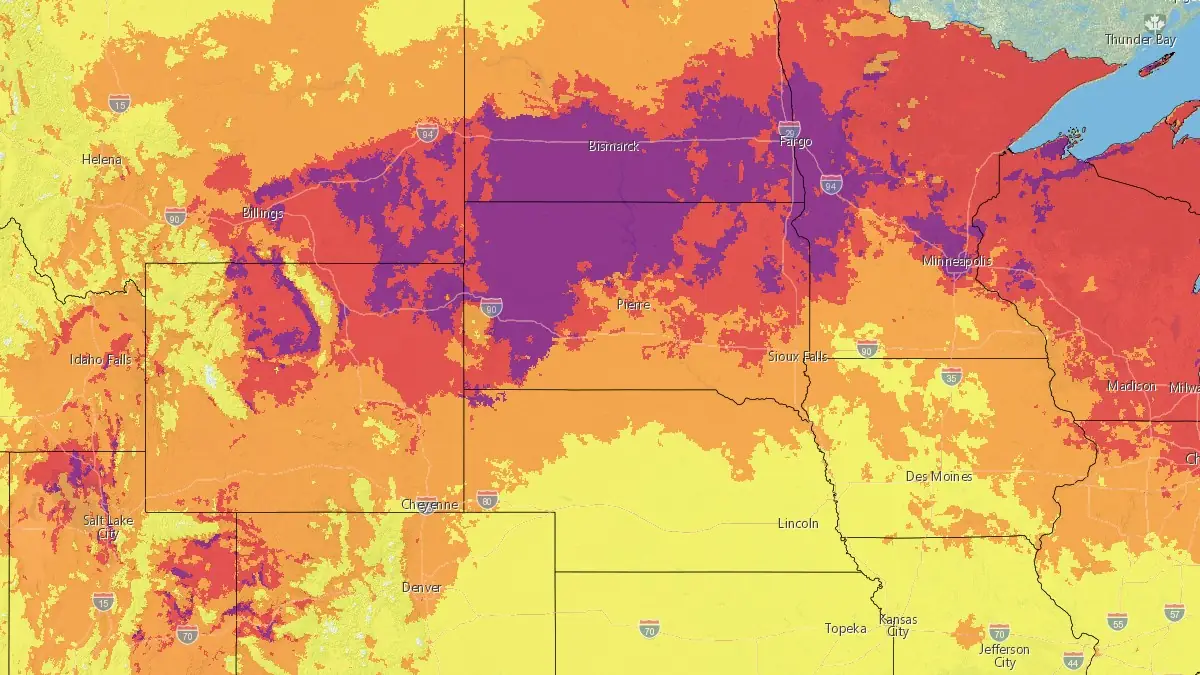
HeatRisk for Tuesday, July 14, 2026. Credit: NWS
The heat wave is being driven by an intensifying upper-level high pressure system centered over the western United States, with an upper-level trough approaching the Pacific Northwest. Together, these systems are pushing unusually hot conditions from the Great Basin into the Northern Plains, with the Weather Prediction Center (WPC) forecasting the heat to peak through July 14.
High temperatures of 35 to 41°C (95 to 105°F) are expected across much of the region, with some locations potentially exceeding 43°C (110°F).
“Even for mid-July, this heat is expected to be exceptionally rare for some locations and produce numerous daily, monthly, and some all-time high temperature records,” the WPC said.
Numerous daily records were broken, and Billings, Montana, shattered its all-time record. Salt Lake City, Utah, reached 41°C (106°F) on July 12, breaking that date’s daily record of 41°C (105°F) set in 2024 and tying for the second-highest temperature ever recorded in the city since 1874 — just short of its all-time record of 41.7°C (107°F).
Billings, meanwhile, hit 43.9°C (111°F) on July 12, decisively breaking its previous all-time record of 41.7°C (107°F), which had stood since 2002. The reading also came with an 8.9°C (16°F) departure from normal and a minimum overnight low of just 18.9°C (66°F).
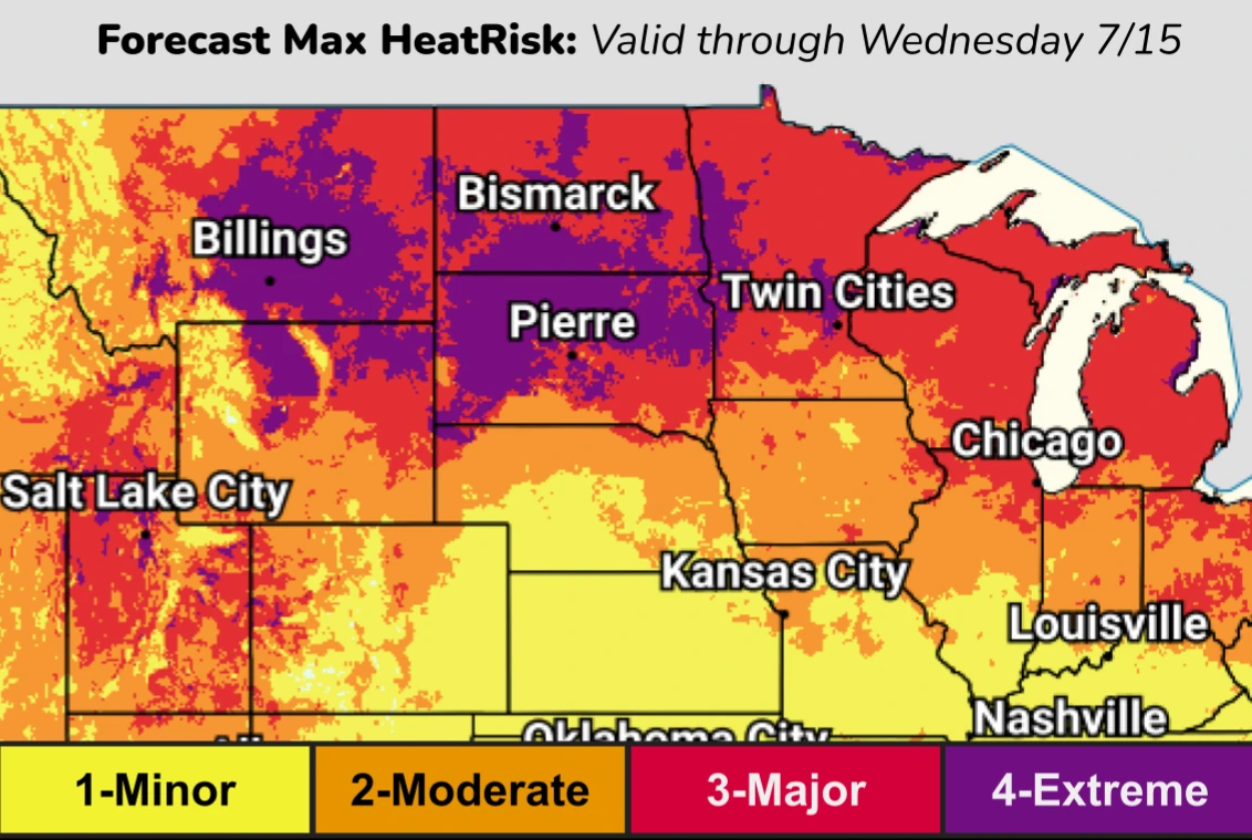
The heat will become more dangerous because nights will remain unusually warm. Temperatures may not cool enough for people, buildings, and infrastructure to recover before the next day begins.
Prolonged daytime heat and record-warm nights are expected to produce widespread Major to locally Extreme HeatRisk. Anyone without reliable cooling or enough water will face the greatest danger.
A cold front moving inland from the Pacific Northwest will bring somewhat cooler air into Montana and parts of the northern Intermountain West later on July 13 into 14, bringing some relief.
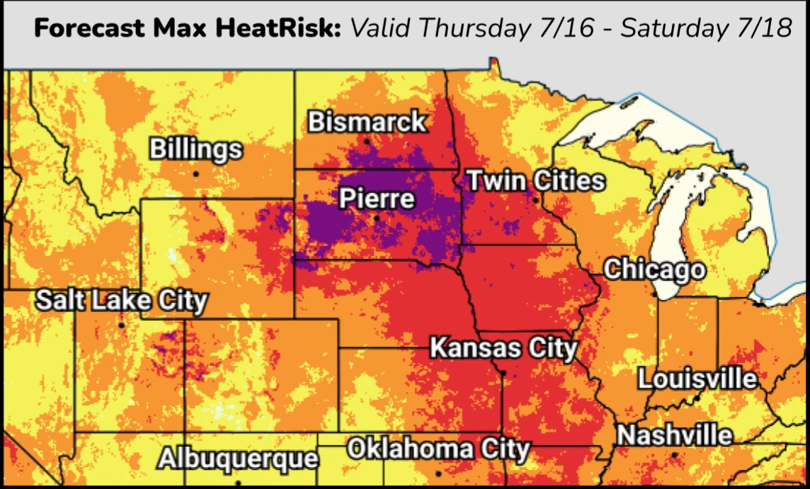
However, the heat wave will continue farther east. Above-average temperatures are forecast to persist across parts of the Corn Belt through next weekend. Very hot conditions will also expand into the Central Plains and Mid-Mississippi Valley. Afternoon highs in the upper 30s°C (upper 90s°F) are expected, and heat index values will remain in the triple digits.
People in the affected areas have been urged to limit outdoor activity during the hottest part of the day. Stay hydrated and take frequent breaks if working outside. Use air conditioning or cooling centers whenever possible.
Check on family members, friends, and neighbors, especially those who are vulnerable, and never leave children or animals unattended inside parked vehicles, the WPC warned.
This heat event marks the second major heat dome of the 2026 North American heat wave, following a late-June episode across the eastern U.S. and Canada that was linked to 44 deaths and pushed power grids, including PJM Interconnection, close to record demand levels.
A secondary resurgence of extreme heat is expected to lock back in across the Northern Rockies, Great Basin, and Northern Plains in the days following July 14, with the WPC flagging continued high risk for the northern Plains and Upper Mississippi Valley into July 16.
The same hot, dry conditions are also elevating wildfire danger across the Great Basin and Southwest, where fast-moving fires have already proven fatal for firefighting personnel this season.
References:
1 Short Range Forecast Discussion – NWS/WPC – July 12, 2026

I am an Assistant Editor and Severe Weather & Science Journalist at The Watchers, specializing in real-time severe weather coverage, geophysical event reporting, and research-driven scientific analysis. You can reach me at rishav(at)watchers(.)news.

Commenting rules and guidelines
We value the thoughts and opinions of our readers and welcome healthy discussions on our website. In order to maintain a respectful and positive community, we ask that all commenters follow these rules.