
Flash Flood Emergency issued after heavy rain in southeast Missouri, United States
The National Weather Service (NWS) issued a Flash Flood Emergency for parts of Iron and Reynolds counties, Missouri, after slow-moving storms produced 152 to 279 mm (6 to 11 inches) of rain by 05:44 CDT (10:44 UTC) on July 10, 2026.
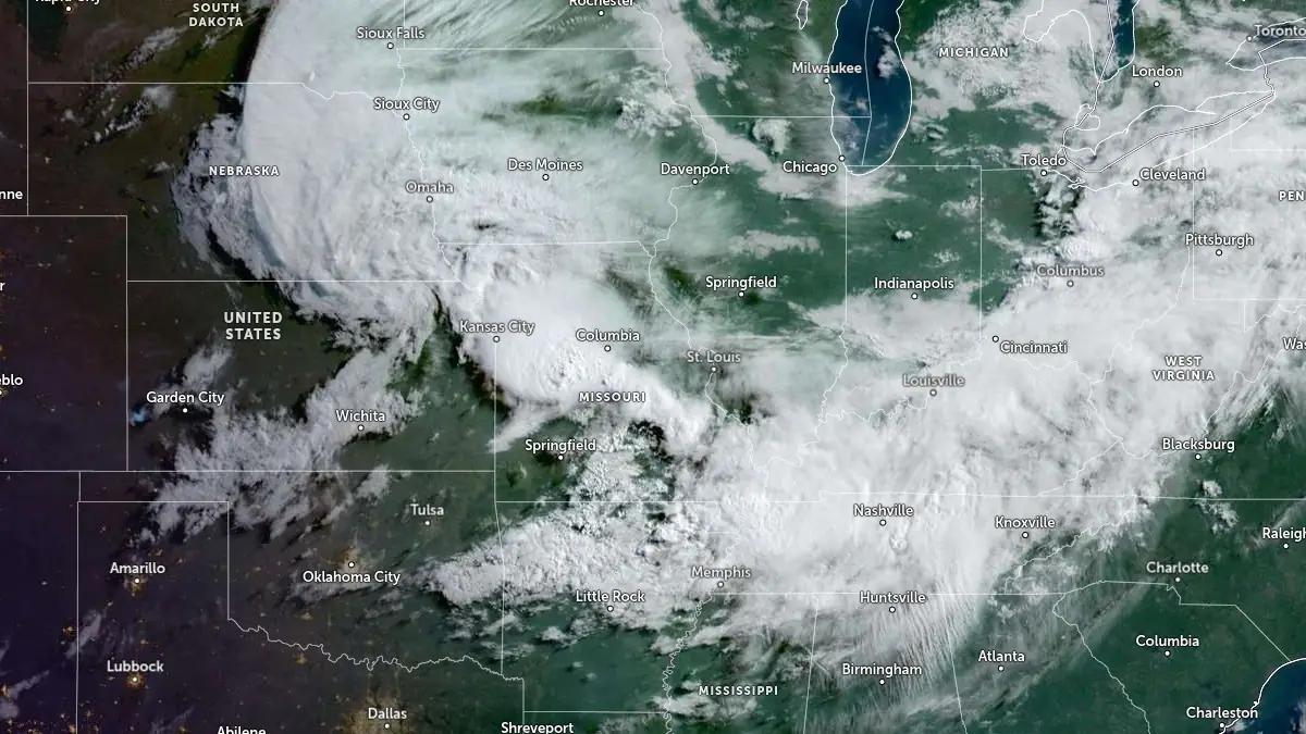
Satellite image centered over Missouri at 12:30 UTC on July 10, 2026. Credit: NOAA/GOES-East, Zoom Earth, The Watchers
The emergency covered northwest and southern Iron County and northeast Reynolds County, including Viburnum, Annapolis, Glover, Oates, Bixby, Lesterville, Black, Hogan, Chloride, and Sabula. Johnsons Shut-Ins State Park and Taum Sauk Mountain State Park were also included in the emergency area.
NWS St. Louis assigned a catastrophic flash flood damage threat and described the event as a particularly dangerous situation. Rainfall rates of 25 to 51 mm (1 to 2 inches) per hour were reported, with an additional 13 to 38 mm (0.5 to 1.5 inches) possible before the warning expired at 10:15 CDT (15:15 UTC). The agency advised people in the emergency area to move to higher ground and avoid travel unless fleeing an area subject to flooding or under an evacuation order.
Additional flash flood warnings were issued across southeast Missouri as heavy rain continued Friday morning. NWS St. Louis extended a Flash Flood Warning for southern Madison County until 11:00 CDT (16:00 UTC), where local law enforcement reported Route C near FF closed due to high water after 127 to 254 mm (5 to 10 inches) of rain. The agency said an additional 25 mm (1 inch) was possible and classified the flooding there as observed, with a considerable flash-flood damage threat.
A separate Flash Flood Warning remained in effect for southwestern Washington County until 10:15 CDT (15:15 UTC). NWS St. Louis said law enforcement reported Route C west of Belgrade closed due to floodwaters after 76 to 152 mm (3 to 6 inches) of rain, with rainfall rates of 25 to 51 mm (1 to 2 inches) per hour.
River flooding was reported on the Black and St. Francis rivers after the flash-flood event. NWS St. Louis reported moderate flooding on the Black River near Annapolis, where the river stage was 4.9 m (16.1 feet) at 07:15 CDT, more than twice the 2.4 m (8 feet) flood stage. The river was forecast to crest at 6.1 m (20 feet) on Friday evening before falling below flood stage late Saturday evening.
NWS Paducah reported minor flooding forecast on the St. Francis River near Patterson after recent heavy rainfall. The river was at 4.6 m (15.2 feet) at 08:30 CDT, below the 4.9 m (16 feet) flood stage, and was forecast to rise above flood stage late Friday morning before cresting at 6.9 m (22.5 feet) Friday evening. NWS forecast the river to fall below flood stage late Saturday morning.
The Missouri Department of Transportation reported multiple flood-related road closures across the affected region Friday morning. In Iron County, closures included MO 143, MO 21, MO 49, Route C, Route F, Route K, and Route N, with entries citing flooding, water over the road, and water, debris, and trees over the road.
MoDOT also reported flood-related closures in Reynolds, Madison, Washington, Wayne, Ripley, and Wright counties. Reynolds County closures included MO 21, Route K, and Route N, while Wayne County closures included MO 143 and Route C over Bear Creek.
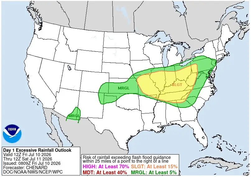
The Weather Prediction Center (WPC) placed portions of the Mid-Mississippi Valley into the Central Appalachians under a Slight Risk of excessive rainfall for the period from 12:00 UTC July 10 to 12:00 UTC July 11.
Slight Risk was expanded northward across portions of Missouri, Illinois, Indiana, and Ohio to account for multiple evolving convective threats, with flash flooding already underway across southern Missouri into portions of Kentucky and Tennessee.
The WPC said slow-moving convection across portions of Indiana, Ohio, and southwest Pennsylvania supported intense rainfall rates locally around 51 mm (2 inches) per hour.
References:
1 WWA Summary – NWS – July 10, 2026
2 Excessive Rainfall Discussion – NWS/WPC – July 10, 2026

I'm a dedicated researcher, journalist, and editor at The Watchers. With over 20 years of experience in the media industry, I specialize in hard science news, focusing on extreme weather, seismic and volcanic activity, space weather, and astronomy, including near-Earth objects and planetary defense strategies. You can reach me at teo /at/ watchers.news.

Commenting rules and guidelines
We value the thoughts and opinions of our readers and welcome healthy discussions on our website. In order to maintain a respectful and positive community, we ask that all commenters follow these rules.