
Super Typhoon Bavi strengthens into Category 5 as Guam, Northern Mariana Islands brace for possible catastrophic impacts
Super Typhoon Bavi reached Category 5 strength over the western North Pacific on Saturday, July 4, 2026 as it tracked toward the Mariana Islands. Forecasters expect the cyclone to pass very near Rota before moving between Guam and Saipan on Monday morning. Typhoon warnings have been issued for Guam, Rota, Tinian, and Saipan amid forecasts of destructive winds, life-threatening coastal inundation, widespread flash flooding and catastrophic damage early next week.
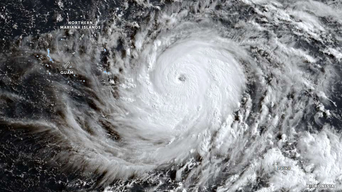
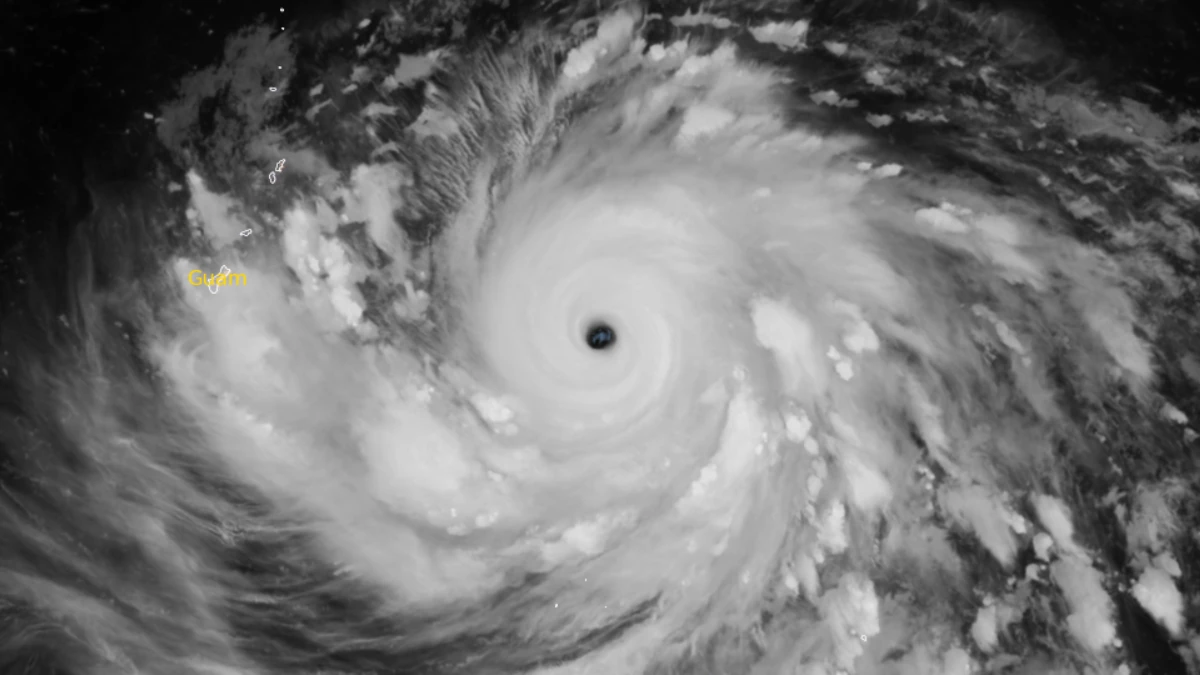
Satellite image of Category 5 super typhoon Bavi at 21:00 UTC on July 3, 2026. JMA/Himwari-9, Zoom Earth, The Watchers
Super Typhoon Bavi strengthened into a Category 5 cyclone over the western North Pacific on Saturday, July 4, as it tracked toward the Mariana Islands.
The National Weather Service (NWS) Guam warned that destructive winds, life-threatening coastal inundation, widespread flash flooding, and catastrophic damage are possible across parts of Guam and the Commonwealth of the Northern Mariana Islands early next week.
Bavi had been upgraded to a Category 4 typhoon by NWS Guam at 02:00 CHST on Saturday (16:00 UTC on Friday). In less than five hours, it reached Category 5 strength with the classification being upgraded by the NWS at 07:00 CHST on Saturday (21:00 UTC on Friday).
The system was located approximately 628 km (390 miles) east of Guam, 595 km (370 miles) east-southeast of Rota, and 587 km (365 miles) east-southeast of Tinian and Saipan at 19:20 ChST (09:20 UTC) on Saturday, according to the NWS. The super typhoon was moving west at 13 km/h (8 mph) with maximum sustained winds of 266 km/h (165 mph).
A Typhoon Warning remains in effect for Guam, Rota, Tinian, and Saipan. A Tropical Storm Watch is also in effect for Alamagan, Pagan, and Agrihan.
Satellite imagery showed continued improvement in the storm’s structure. The eye, measuring about 33 km (21 miles) in diameter, became better defined as the central dense overcast grew more symmetrical, cloud-top temperatures cooled, and upper-level outflow expanded.
Microwave imagery also showed a strong inner core surrounded by a ring of weaker convection, while the Cooperative Institute for Meteorological Satellite Studies’ MPERC algorithm estimated a 64% probability that an eyewall replacement cycle had begun.
Forecast guidance indicates that Bavi will continue moving generally west before turning west-northwest during the 12 to 24 hours from 09:00 UTC on Saturday as the steering pattern evolves. The official forecast continues to bring the center of the super typhoon very near Rota before it passes between Guam and Saipan on Monday morning.
JTWC expects the developing eyewall replacement cycle to produce some temporary weakening during the next 24 hours before the cyclone restrengthens. If the replacement cycle completes quickly, enhanced upper-level outflow developing near Japan could support renewed intensification to at least 278 km/h (173 mph) as Bavi approaches the Mariana Islands.
The agency also forecasts the storm to expand significantly in size during the eyewall replacement cycle, extending dangerous conditions farther from the center.
While confidence in the forecast track remains high through at least five days, confidence in the intensity forecast is lower during the first 72 hours because the timing and effects of the eyewall replacement cycle remain uncertain.
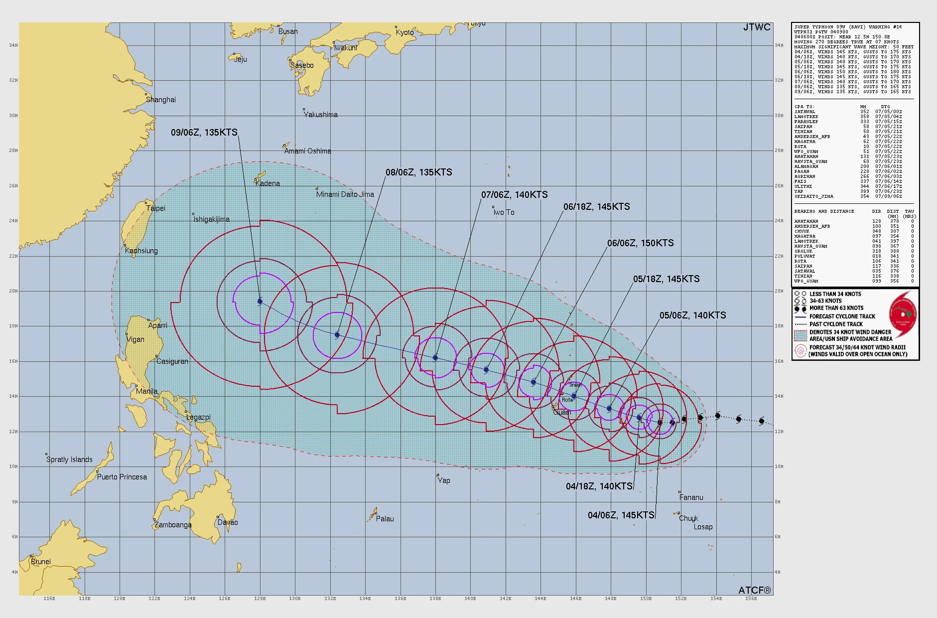
Tropical-storm-force conditions are expected to begin late Sunday afternoon or Sunday evening, with typhoon conditions developing early Monday morning and potentially continuing into Monday afternoon. The agency warned that all islands across the southern Mariana Islands are expected to experience significant impacts regardless of the exact track.
Destructive typhoon conditions could persist for 8 to 10 hours near the center of the storm. Maximum sustained winds of around 257 km/h (160 mph), with gusts reaching approximately 306 km/h (190 mph), are possible near the center if the current forecast verifies. The greatest risk currently extends across Rota, although even modest shifts in the forecast track could significantly alter where the most severe conditions occur.
Dangerous marine conditions are expected well ahead of Bavi’s arrival. Surf along east-facing reefs around Guam and the southern Commonwealth of the Northern Mariana Islands is forecast to build from 1 to 2 m (4 to 7 feet) on Saturday to 2 to 4 m (8 to 12 feet) Saturday night before potentially reaching 8 to 11 m (25 to 35 feet) as the cyclone passes. Coastal inundation of 3 to 5 m (10 to 15 feet) and significant coastal erosion are also possible.
Rainfall totals of 305 to 508 mm (12 to 20 inches) may occur across portions of the Mariana Islands as the cyclone’s eye passes through, increasing the threat of life-threatening flash flooding and mudslides. Alamagan, Pagan, and Agrihan could receive 76 to 152 mm (3 to 6 inches) of rainfall, with locally higher amounts possible.
NWS Guam urged residents under the Typhoon Warning to complete all preparations immediately, including securing homes and businesses, installing storm shutters or plywood where appropriate, securing boats, obtaining emergency supplies, and evacuating vulnerable structures if directed by local officials.
The agency warned that outdoor preparations will become increasingly dangerous once damaging winds begin on Sunday.
References:
1 Super Typhoon Bavi (09W) Advisory Number 14 – NWS – July 4, 2026
2 Typhoon Bavi (09W) Local Statement – NWS – July 4, 2026
3 Prognostic Reasoning for Super Typhoon 09W (Bavi), Warning No. 14 – JTWC – July 4, 2026

I am an Assistant Editor and Severe Weather & Science Journalist at The Watchers, specializing in real-time severe weather coverage, geophysical event reporting, and research-driven scientific analysis. You can reach me at rishav(at)watchers(.)news.
Commenting rules and guidelines
We value the thoughts and opinions of our readers and welcome healthy discussions on our website. In order to maintain a respectful and positive community, we ask that all commenters follow these rules.