
Typhoon Bavi forecast to approach the Mariana Islands as a Category 5 super typhoon
Typhoon Bavi rapidly intensified over the western North Pacific on Friday, July 3, 2026, increasing from 157 km/h (98 mph) to 194 km/h (121 mph) within six hours. The storm is forecast to continue strengthening and potentially become a Category 5 equivalent super typhoon over the weekend or early next week. Typhoon, tropical storm, and flood watches remained in effect Friday across Guam and the Commonwealth of the Northern Mariana Islands.
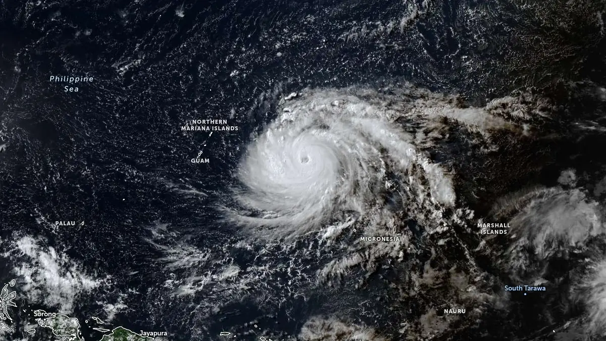
Satellite image of Typhoon Bavi at 06:30 UTC on July 3, 2026. Credit: JMA/Himawari-9, Zoom Earth, The Watchers
Typhoon Bavi continued to strengthen rapidly over the western North Pacific on Friday, July 3, as forecasters warned the cyclone poses a significant and growing threat to the Mariana Islands early next week.
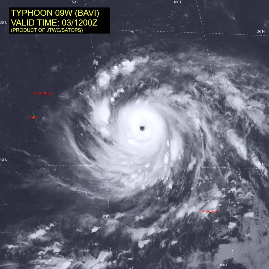
Bavi was upgraded to typhoon status while continuing to track toward the Mariana Islands, at 07:00 ChST on July 3 (21:00 UTC on July 2) by the Joint Typhoon Warning Center (JTWC).
At that time, the cyclone was centered about 1 223 km (760 miles) east of Guam and 1 151 km (715 miles) east-southeast of Saipan, moving west-northwest at 23 km/h (14 mph) with maximum sustained winds of 129 km/h (80 mph), making it a Category 1 typhoon.
Later Friday evening, the National Weather Service (NWS) Guam reported that Bavi had strengthened further, with maximum sustained winds increasing to 201 km/h (125 mph).
At 22:00 ChST (12:00 UTC), the typhoon was located about 902 km (560 miles) east of Guam, 837 km (520 miles) east-southeast of Saipan, 845 km (525 miles) east-southeast of Tinian, 860 km (535 miles) east of Rota, 942 km (585 miles) southeast of Alamagan, 980 km (610 miles) southeast of Pagan and 1 030 km (640 miles) southeast of Agrihan while moving west at 21 km/h (13 mph).
Bavi rapidly intensified from 157 km/h (98 mph) to 194 km/h (121 mph) between 03:00 and 09:00 UTC on July 3, according to the JTWC.
Satellite imagery showed a steadily improving cyclone structure, including a well-defined eyewall, a symmetric central dense overcast completely surrounding the eye, warming eye temperatures, and robust radial outflow, all consistent with a rapidly intensifying tropical cyclone.
JTWC assessed the environment as highly favorable for continued rapid intensification. Deep-layer vertical wind shear remained low at 9–19 km/h (6–11 mph), while sea-surface temperatures ranged from 29 to 30°C (84–86°F). Significant wave heights of 12 m (39 feet) were also reported.
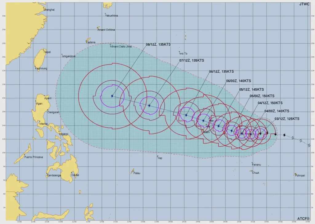
Bavi is forecast to continue moving generally westward before turning west-northwest as it approaches the Mariana Islands.
JTWC currently expects the closest approach to Saipan and Rota around 22:00 UTC on July 5, while NWS Guam forecasts the cyclone to move through the Marianas as a very dangerous Category 5 super typhoon on Monday morning if the current forecast verifies.
The center forecasts rapid intensification to continue through approximately 36 hours, with peak intensity expected to reach 278 km/h (173 mph). Thereafter, increasing vertical wind shear is expected to gradually weaken the cyclone. JTWC also highlighted a high probability of an eyewall replacement cycle, which could alter the timing and magnitude of peak intensity while expanding the wind field.
A Typhoon Watch remains in effect for Guam, Rota, Tinian, and Saipan, while a Tropical Storm Watch is in effect for Alamagan, Pagan, and Agrihan. A Flood Watch also remains in effect across Guam and the Commonwealth of the Northern Mariana Islands. According to the latest advisory, typhoon-force winds extend outward up to 80 km (50 miles) from the center, while tropical-storm-force winds extend up to 241 km (150 miles) north of the center and 169 km (105 miles) south of the center.
NWS Guam forecasts tropical-storm-force winds could begin affecting Guam and the southern Commonwealth of the Northern Mariana Islands as early as Sunday morning, although the current forecast favors Sunday evening. Typhoon-force winds are forecast from Monday morning through late Monday afternoon. Across Alamagan, Pagan, and Agrihan, tropical-storm-force winds are forecast from Monday morning through Tuesday morning.
Marine conditions are expected to deteriorate rapidly. Surf along east-facing reefs around Guam and the southern Commonwealth of the Northern Mariana Islands is forecast to build from 1–1.5 m (3–5 feet) to 2–4 m (8–12 feet) Saturday night before potentially reaching 6–10 m (20–30 feet) near the typhoon’s closest approach. Across Alamagan, Pagan and Agrihan, surf is forecast to increase to 2–3 m (7–9 feet) Saturday night before reaching 3.0–4.3 m (10–14 feet) as Bavi passes to the south.
Rainfall totals of 125–250 mm (5–10 inches), with locally higher amounts, are forecast for Guam and the southern Commonwealth of the Northern Mariana Islands between Sunday morning and Wednesday afternoon. Across Alamagan, Pagan, and Agrihan, 75–150 mm (3–6 inches), with locally higher totals, are forecast during the same period, raising the potential for flash flooding.
Special Weather Statements also remain in effect for Chuuk, Pohnpei, and Kosrae. Although Bavi is forecast to pass north of the Federated States of Micronesia, residents should expect strengthening west winds, showers, thunderstorms, and periods of locally heavy rainfall during the coming days.
Authorities urged residents across Guam and the Commonwealth of the Northern Mariana Islands to complete storm preparations while watches remain in effect.
Recommended actions include securing homes and businesses, installing shutters or plywood where appropriate, bringing loose outdoor objects indoors, reinforcing exterior and garage doors, assembling emergency supplies, obtaining fuel, food, and medications before conditions deteriorate, and monitoring official forecasts for possible warnings or evacuation orders.
Boat owners were advised to secure vessels and relocate to adequate land-based shelter, ports and marinas should complete tropical cyclone preparedness procedures, and small craft should return to port or seek safe harbor.
References:
1 Prognostic reasoning for Typhoon Bavi – JTWC – July 3, 2026
2 Typhoon Bavi (09W) Local Statement – NWS – July 3, 2026
3 Typhoon Bavi (09W) Intermediate Advisory Number 10A – NWS – July 3, 2026

I am an Assistant Editor and Severe Weather & Science Journalist at The Watchers, specializing in real-time severe weather coverage, geophysical event reporting, and research-driven scientific analysis. You can reach me at rishav(at)watchers(.)news.
Commenting rules and guidelines
We value the thoughts and opinions of our readers and welcome healthy discussions on our website. In order to maintain a respectful and positive community, we ask that all commenters follow these rules.