
Two killed and 230 rescued as catastrophic flash floods strike Texas
At least two people were killed and 230 rescued after repeated thunderstorms produced catastrophic flash flooding across the Texas Hill Country and south-central Texas on July 16, 2026. Up to 711 mm (28 inches) of rain fell in northern Uvalde County over three days, while the Guadalupe River at Comfort rose more than 9 m (30 feet) in under three hours and crested near 11.3 m (37 feet). Texas deployed more than 2 350 emergency responders and over 1 400 response assets as flood waves moved through several river basins.
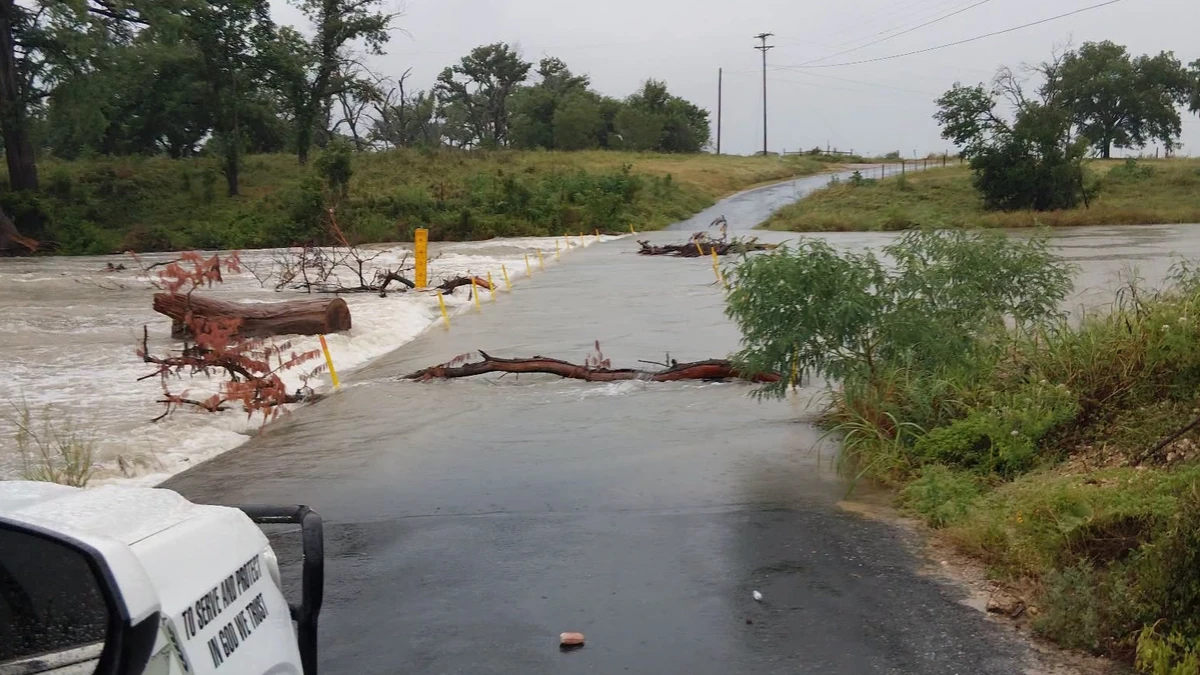
Flooding in Kerr County, Texas on July 15, 2026. Credit: Kerr County Sheriff's Office
The Texas Hill Country and surrounding areas were affected by severe flooding for a third consecutive day after slow-moving thunderstorms repeatedly developed over the same areas beginning on Tuesday, July 14.
The National Weather Service (NWS) reported that 254 to 508 mm (10 to 20 inches) of rain fell across parts of the Hill Country during the two days preceding the peak flooding. Accumulations approached 711 mm (28 inches) at isolated locations in northern Uvalde County during the three-day event.
State and local officials confirmed two flood-related deaths by Thursday evening.
In Kerr County, a resident died after rapidly rising water swept away his mobile home near Goat Creek, which flows into the Guadalupe River. The occupant contacted a neighbor shortly after 03:00 LT on Thursday after water began entering the residence, but the structure was carried away before help could reach him.
The second fatality occurred approximately 6 km (4 miles) north of Uvalde after a driver entered high water near the intersection of U.S. Highway 83 and County Road 400.
Authorities had not released a consolidated report of missing people by early Friday.
Emergency crews rescued 230 people from flooded homes, vehicles, rooftops, campgrounds, and isolated properties. Operations included the helicopter rescue of a man and his dog from the roof of a stranded truck.
Rescues were conducted using Black Hawk helicopters, swiftwater boats, high-water vehicles, drones, rescue swimmers, and ground search-and-rescue teams. The Kerr County Sheriff’s Office reported that all campers in the county were accounted for.
“We’re facing record-shattering rainfall that leads to very dangerous flooding,” Texas Governor Greg Abbott said during a state briefing on Thursday. He urged residents to avoid flooded roads as flood waves continued moving downstream.
Abbott said Texas had deployed more than 2 350 emergency responders and over 1 400 vehicles and other response assets. The deployment included personnel and equipment from the Texas Military Department, Texas Parks and Wildlife Department, Texas Department of Public Safety, Texas A&M Task Force 1, Texas Department of Transportation, and other state and local agencies.
The Guadalupe River underwent extreme rises as runoff entered the basin early Thursday.
At Comfort, the river rose from approximately 1.6 m (5.4 feet) at 04:40 LT to more than 11.2 m (36.6 feet) by 07:30 LT. It later crested near 11.3 m (37 feet), more than 0.3 m (1 foot) above the crest recorded at the location during the July 4, 2025 flood.
Gauges farther upstream at Hunt, Kerrville, and Center Point also recorded rapid rises before water levels began receding Thursday afternoon. Despite falling levels upstream, the large flood wave continued moving downstream toward Kendall and Comal counties.
Comal County issued a mandatory evacuation for properties along the Guadalupe River from the county line at Guadalupe River State Park to FM 311 on Thursday evening. Residents were instructed to leave while roads remained passable, and Spring Branch Middle School was opened as an emergency shelter.
The Guadalupe River near Spring Branch was forecast to rise to approximately 12.2 m (40 feet), exceeding the major flood stage of 11.9 m (39 feet). At that level, the NWS warned that low residences, secondary roads, bridges, parks, marinas, and facilities between Kendall County and Canyon Lake could be flooded.
Evacuation shelters were also opened at Calvary Temple Church in Kerrville, Citywest Church in Ingram, the Center Point Independent School District gymnasium, Comfort High School, and several locations in Uvalde.
During Thursday’s state briefing, officials said the Nueces River near Uvalde was expected to challenge or exceed its 1996 record crest, while the Frio and Pedernales rivers were forecast to reach some of their highest levels on record.
Major flooding also affected the Sabinal River, Cibolo Creek, and numerous smaller tributaries across the Hill Country, southern Edwards Plateau, and Rio Grande Plains.
The NWS issued multiple Flash Flood Emergencies as rapidly rising flood waves moved through Kerr, Kendall, Uvalde, Gillespie, and Blanco counties. Life-threatening flooding affected or threatened communities including Kerrville, Hunt, Ingram, Center Point, Comfort, Fredericksburg, Johnson City, and Uvalde.
At least 125 roadway segments were affected statewide, including 87 that remained closed during Thursday’s response operations.
Flooding closed sections of U.S. Highway 90 between Uvalde and Del Rio. U.S. Highway 83, State Highway 55, FM 2369, and FM 481 were also among the routes blocked in and around Uvalde County.
Local officials warned that motorists bypassing barricades were diverting emergency personnel from rescues involving people trapped in homes and vehicles. Uvalde was temporarily cut off from outside road access after water covered the principal state highways entering and leaving the city.
Floodwaters also damaged infrastructure in Kerr County. A section of the Arcadia Loop bridge near the confluence of Goat Creek and the Guadalupe River was washed away, leaving a gap estimated at approximately 15 m (50 feet).
Governor Abbott’s disaster declaration covered 59 counties and activated emergency response plans across affected parts of Texas.
A Flood Watch remained in effect for parts of the Hill Country, southern Edwards Plateau, and Rio Grande Plains through 17:00 UTC (12:00 LT) on Friday. The NWS forecast an additional 51 to 102 mm (2 to 4 inches) of rain through Friday morning, with isolated accumulations approaching 203 mm (8 inches).
In an outlook issued at 08:28 UTC on July 17, the Weather Prediction Center (WPC) placed much of southwestern and south-central Texas under a Slight Risk, level 2/4, of excessive rainfall for the period from 12:00 UTC on July 17 to 12:00 UTC on July 18.
WPC said high-resolution guidance showed substantially less coverage of heavy rainfall than during the preceding days. The greatest threat was expected to shift west toward the Davis Mountains, although deep atmospheric moisture and a strengthening low-level jet would maintain a localized risk of additional heavy rain and flash flooding.
Saturated ground, damaged roads and bridges, closed low-water crossings, and flood waves continuing downstream meant that dangerous conditions could persist after rainfall ended.
The flooding occurred less than two weeks after the first anniversary of the catastrophic July 4, 2025 flood disaster in central Texas.
That event killed at least 135 people across several counties. Kerr County accounted for 119 victims, including two people who had not been found when a Texas legislative report was released in June 2026.
Camp Mystic lost 28 people during the 2025 disaster: 25 campers, two counselors, and the camp’s co-executive director.
During that event, approximately 254 to 381 mm (10 to 15 inches) of rain fell over the upper Guadalupe River basin. The Guadalupe River at Hunt rose from approximately 3 m (10 feet) at 03:00 LT to a crest of 11.4 m (37.52 feet) at 05:10 LT on July 4, 2025.
References:
1 Governor Abbott Provides Update On State Response To Severe Flooding – Texas.gov – July 16, 2026
2 Guadalupe River near Spring Branch – NWS/WPC – July 17, 2026
3 REPORT ON THE CAMP MYSTIC FLOOD DISASTER OF JULY 4, 2025 – Texas.gov – Accessed July 17, 2026

I am an Assistant Editor and Severe Weather & Science Journalist at The Watchers, specializing in real-time severe weather coverage, geophysical event reporting, and research-driven scientific analysis. You can reach me at rishav(at)watchers(.)news.

Commenting rules and guidelines
We value the thoughts and opinions of our readers and welcome healthy discussions on our website. In order to maintain a respectful and positive community, we ask that all commenters follow these rules.