
Typhoon Mekkhala and Higos to merge south of Honshu, heavy rain and rough seas forecast for Japan
Typhoon Mekkhala and Tropical Depression Higos are forecast to merge south of Honshu on June 26, 2026, bringing heavy rain, rough seas, and strong winds to large parts of Japan through June 27.
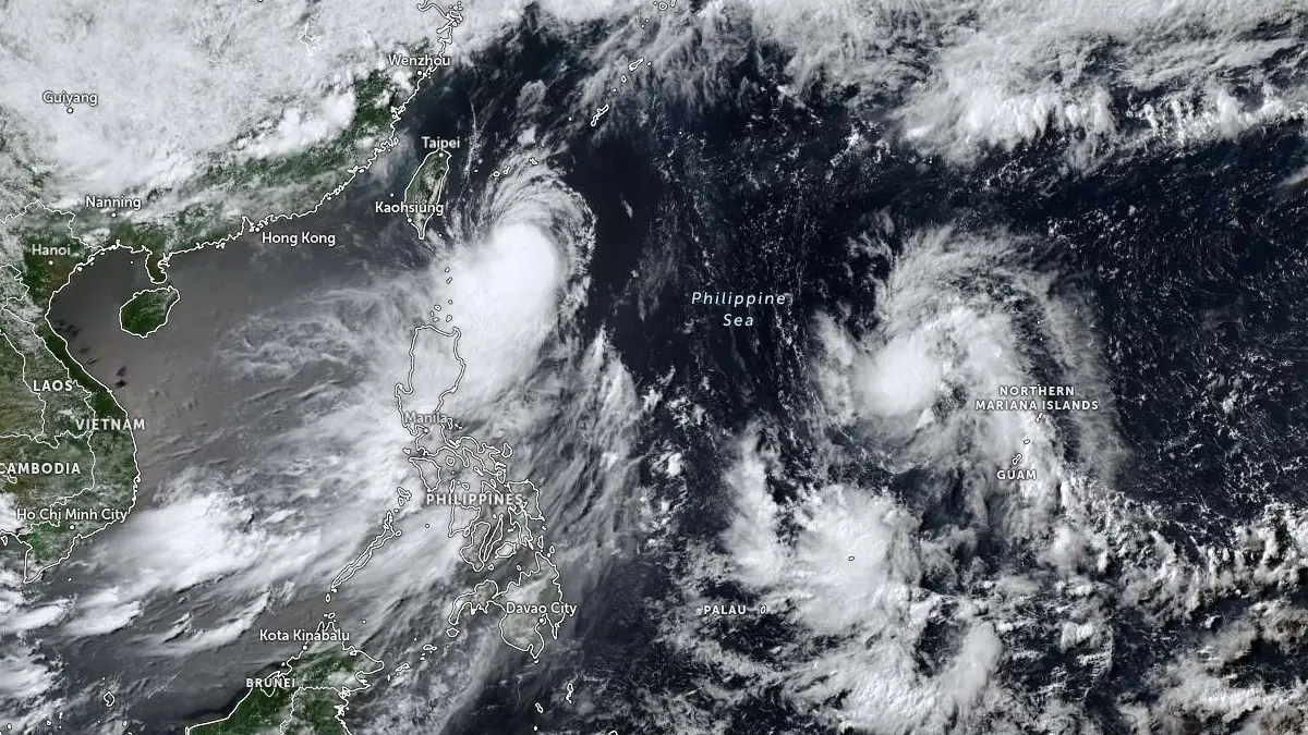
Satellite image of Typhoon Mekkhala and Tropical Depression Higos at 06:40 UTC on June 24, 2026. Credit: JMA/Himawari-9, Zoom Earth, The Watchers
Two tropical cyclones swirling south of Japan are forecast to bring severe weather across much of the country this week. The first is Typhoon Mekkhala, and the second is Tropical Depression Higos.
The Japan Meteorological Agency (JMA) forecasts that Mekkhala will maintain severe tropical storm strength as it approaches the Nansei Islands and moves close to southern Japan from June 24 through 27.
The system was located approximately 604 km (375 miles) south-southwest of Kadena Air Base in Okinawa at 09:00 UTC on June 24, according to the Joint Typhoon Warning Center (JTWC). One-minute maximum sustained winds reached 130 km/h (81 mph), and the system was moving northward at 17 km/h (11 mph). The estimated minimum central pressure was 975 hPa at the time, according to JMA.
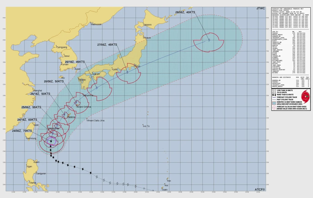
While Mekkhala is not forecast to make landfall, it will continue moving northward, following a track parallel to the northwestern coast of Okinawa through June 25, and then recurve toward the northeast by June 26.
The system will continue accelerating as it moves close to the southeastern coast of Honshu on June 26. Severe weather impacts could extend to the Kanto Plain as the storm moves close to Tokyo Bay.
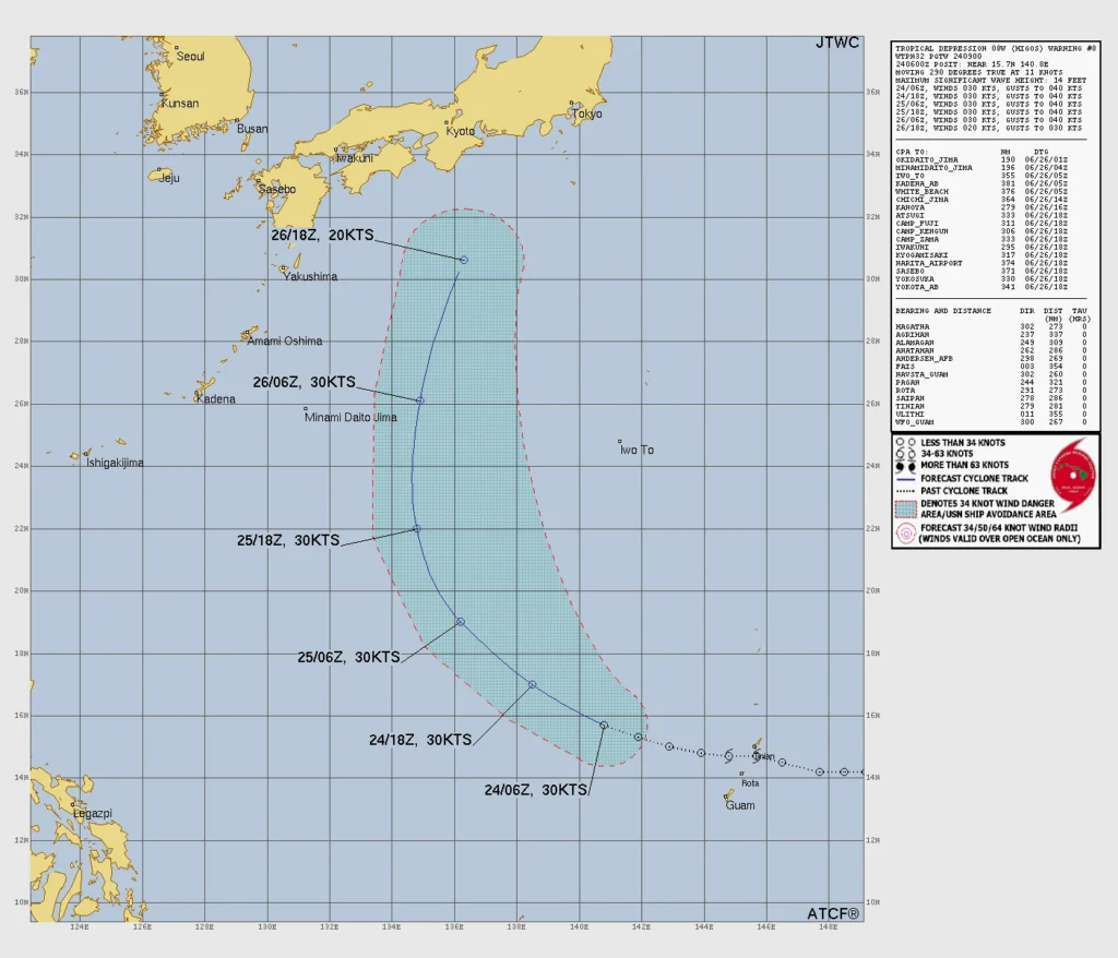
Higos is a tropical depression located 493 km (306 miles) west-northwest of Andersen Air Force Base in Yigo, Guam, at 09:00 UTC on June 24. It had one-minute sustained winds of 56 km/h (35 mph) and was moving west-northwest at 20 km/h (12 mph). The estimated minimum central pressure was 1 000 hPa, according to the JMA.
The system is forecast to merge with Mekkhala south of Honshu on June 26, according to the JTWC.
Marine conditions around Okinawa are expected to deteriorate as Mekkhala approaches. JMA forecasts wave heights of 5 m (16.4 feet) on June 24, increasing to 7 m (23 feet) on June 25 and 26, accompanied by swells.
Rainfall totals in Okinawa are expected to reach up to 60 mm (2.4 inches) during the 24-hour period ending 21:00 UTC on June 25, equivalent to 06:00 JST on June 26. An additional 150 mm (5.9 inches) of rain is forecast during the following 24-hour period.
Authorities warned that the expected rainfall may trigger landslides, flooding in low-lying areas, and rising river levels.
Even before Mekkhala’s closest approach, moist air associated with the seasonal rain front has been producing heavy rainfall across parts of western Japan. Heavy rain warnings and evacuation orders were issued in Kagoshima and Miyazaki prefectures, while several landslides have already been reported in Kagoshima Prefecture.
References:
1 Prognostic Reasoning for Typhoon 07W (Mekkhala), Warning No. 23 – JTWC – June 24, 2026
2 JTWC Prognostic Reasoning for Tropical Depression 08W (Higos), Warning No. 008 – JTWC – June 24, 2026
3 Double barrage of storms to hit Japan this week – The Japan Times – June 24, 2026

I am an Assistant Editor and Severe Weather & Science Journalist at The Watchers, specializing in real-time severe weather coverage, geophysical event reporting, and research-driven scientific analysis. You can reach me at rishav(at)watchers(.)news.
Commenting rules and guidelines
We value the thoughts and opinions of our readers and welcome healthy discussions on our website. In order to maintain a respectful and positive community, we ask that all commenters follow these rules.