
Typhoon Bavi to bring extreme rain to Taiwan before landfall in eastern China
Typhoon Bavi continued to weaken gradually on July 9, 2026, while tracking toward northern Taiwan and eastern China. Taiwan’s Central Weather Administration warned of up to 900 mm (35 inches) of rain in northern mountainous areas through Sunday, while Chinese authorities forecast landfall along the Fujian–Zhejiang coast on the evening of July 11.
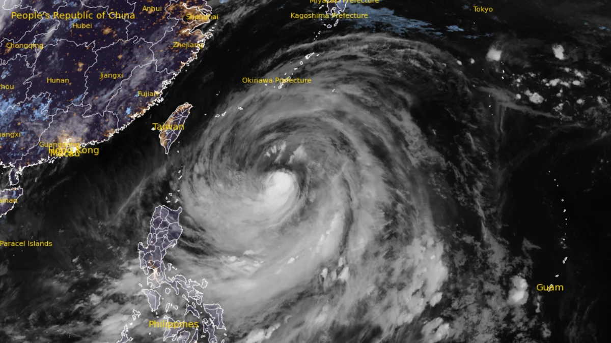
Satellite image of typhoon Bavi at 17:40 UTC on July 9, 2026
Typhoon Bavi was located approximately 817 km (508 miles) south of Kadena at 15:00 UTC on July 9, according to the Joint Typhoon Warning Center (JTWC). The system had 1-minute maximum sustained winds of 185 km/h (115 mph) and was moving north-northwest at 10 km/h (6 mph).
Taiwan’s Central Weather Administration (CWA) reported that Bavi had an estimated minimum central pressure of 930 hPa at 15:00 UTC on July 9. Maximum sustained winds near the center were estimated at 173 km/h (107 mph), with gusts reaching 209 km/h (130 mph).
The cyclone was moving northwest at 21 km/h (13 mph) and was forecast to accelerate slightly over the following 24 hours.
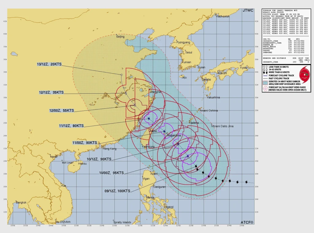
The ongoing eyewall replacement cycle had likely been interrupted by persistent vertical wind shear, preventing the secondary eyewall from fully consolidating, according to the JTWC.
Despite the gradual weakening of the inner core, JTWC expects Bavi to maintain a very large wind field as it tracks northwestward.
Gale-force winds are forecast to affect a broad area extending from Taiwan through the Ryukyu Islands to Okinawa before the cyclone approaches eastern China.
Track guidance remains tightly clustered through the pre-landfall period, and JTWC continues to forecast landfall along the eastern coast of China shortly after 48 hours, with high confidence in the track forecast through 72 hours.
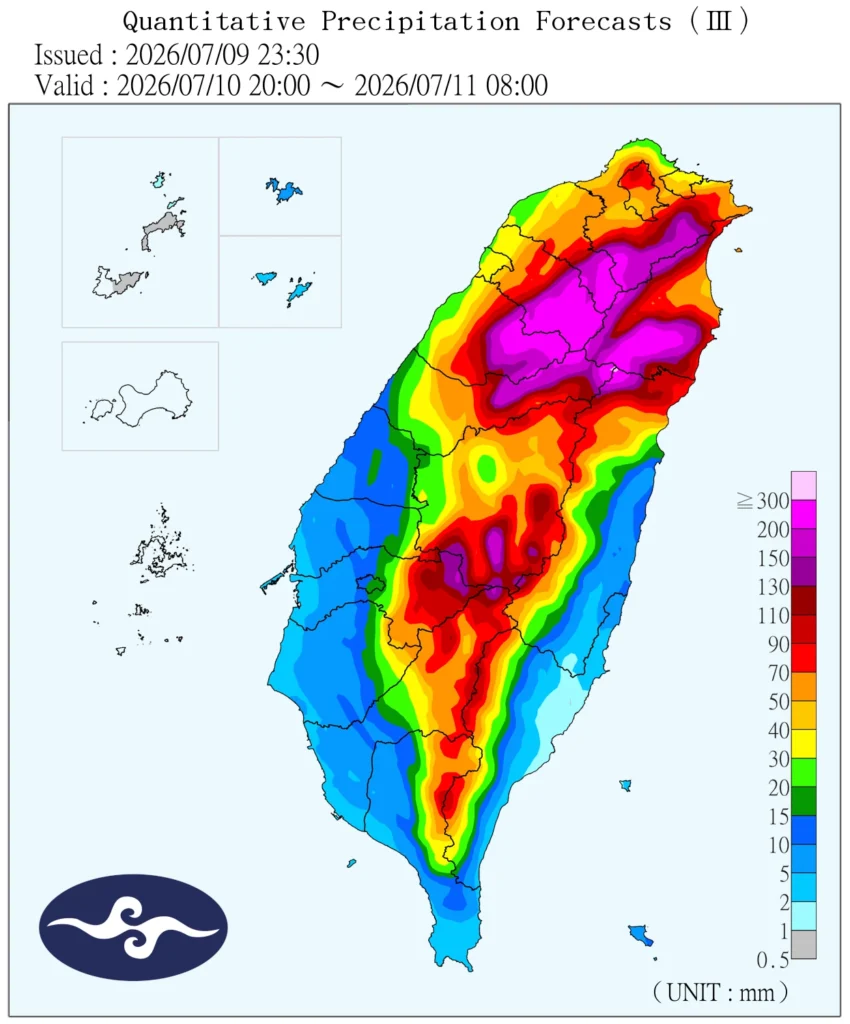
CWA said Bavi is forecast to pass through waters north of Taiwan, although slight shifts in the track mean landfall on the island cannot yet be ruled out.
The CWA forecast 600–900 mm (24–35 inches) of rain in mountainous areas of New Taipei, Taoyuan, Hsinchu County, and Miaoli County through Sunday. Low-lying areas of New Taipei could receive 500–700 mm (20–28 inches), while Hsinchu and Miaoli counties could receive 400–600 mm (16–24 inches).
The agency also warned of dangerous seas, with waves exceeding 6 m (20 feet) expected along parts of Taiwan’s coast. Waves up to 7 m (23 feet) had already been observed off Taitung and Orchid Island by Thursday evening.
Authorities in Taiwan expanded preparedness measures ahead of the storm, with approximately 29 000 military personnel placed on standby for disaster response. In addition, 24 helicopters, 3 355 rescue vehicles and vessels, and 2 664 water pumps are pre-positioned nationwide.
Chinese authorities also intensified preparations ahead of the expected landfall. China’s Ministry of Emergency Management said Bavi was forecast to make landfall on the evening of July 11 along the coast from Fuqing in Fujian Province to Wenling in Zhejiang Province.
The ministry said parts of Zhejiang and Fujian could see heavy rain, very heavy rain, and locally extreme rainfall from July 11, with additional heavy rainfall possible from July 12 in Jiangxi, Hubei, Anhui, Henan, Hebei, and Shandong.
Heavy rainfall, destructive winds, dangerous seas, coastal flooding, and landslides remain the primary hazards as Bavi approaches Taiwan and eastern China.
References:
1 Prognostic Reasoning for Typhoon 09W (Bavi), Warning No. 035 – JTWC – July 9, 2026
2 Typhoon Bavi Sea Typhoon Warning – CWA – July 9, 2026

I am an Assistant Editor and Severe Weather & Science Journalist at The Watchers, specializing in real-time severe weather coverage, geophysical event reporting, and research-driven scientific analysis. You can reach me at rishav(at)watchers(.)news.

Commenting rules and guidelines
We value the thoughts and opinions of our readers and welcome healthy discussions on our website. In order to maintain a respectful and positive community, we ask that all commenters follow these rules.