
El Niño develops, NOAA estimates 63% chance of a very strong event in 2026–27 winter
El Niño conditions have developed in the tropical Pacific Ocean and are expected to strengthen through the Northern Hemisphere winter of 2026-27, according to the National Oceanic and Atmospheric Administration (NOAA). The Climate Prediction Center (CPC) issued an El Niño Advisory on June 11, 2026, after oceanic and atmospheric conditions shifted into an El Niño pattern.
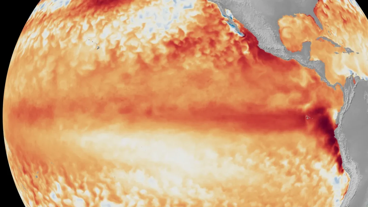
Satellite imagery showing the difference from average sea surface temperatures at the equator in the tropical Pacific Ocean. Credit: NOAA
According to NOAA’s latest ENSO Diagnostic Discussion, above-average sea surface temperatures expanded across the central and eastern equatorial Pacific during the past month.
The latest weekly Niño-3.4 index reached +0.7°C (+1.3°F), while the Niño-4 and Niño-1+2 regions measured +0.7°C (+1.3°F) and +2.1°C (+3.8°F), respectively.
NOAA said atmospheric conditions also changed in ways that are consistent with El Niño. These changes included low-level westerly wind anomalies, upper-level easterly wind anomalies, increased thunderstorm activity over parts of the central and east-central equatorial Pacific, and negative Southern Oscillation Index values. Together, these indicators show that the ocean and atmosphere are now working together in a coupled El Niño state.
The CPC’s ENSO Alert System status is now El Niño Advisory. NOAA said the North American Multi-Model Ensemble forecast shows El Niño strengthening through late 2026 and into the Northern Hemisphere winter of 2026-27. Forecasters said confidence in the outlook remains high, partly because ocean heat content across the equatorial Pacific remains unusually high.
Forecasters estimate a 63% chance that El Niño will reach very strong intensity during the November 2026 through January 2027 period.
If that occurs, the event would rank among the strongest El Niño episodes in the historical record dating back to 1950. NOAA noted that even very strong El Niño events do not produce expected impacts in every location, although stronger events generally increase the probability of typical El Niño-related climate patterns.
El Niño is the warm phase of the El Niño-Southern Oscillation (ENSO), a natural climate pattern that affects weather and ocean conditions around the world. Its effects are usually strongest during the Northern Hemisphere winter, when changes in tropical Pacific temperatures can influence large-scale weather patterns.
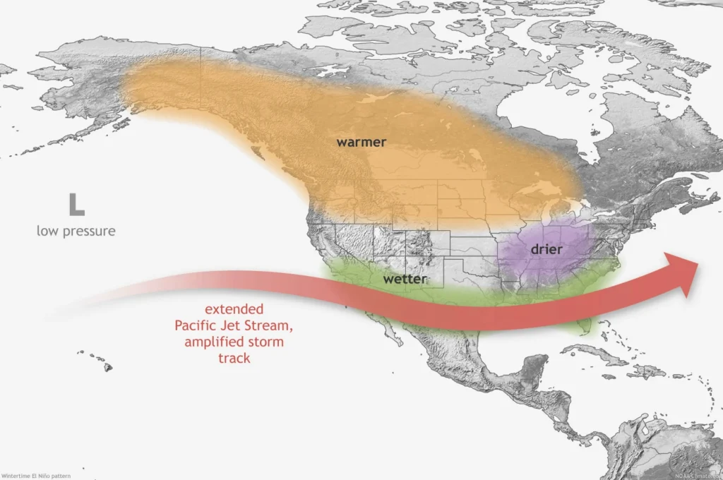
Typical El Niño winter shifts the Pacific jet stream farther south. This often brings a more active storm track across the southern United States, increasing the chances of rain and snow in some areas.
At the same time, drier conditions often develop across parts of the Northern Rockies and portions of the Ohio and Tennessee valleys. Much of the northern United States also tends to experience warmer-than-average winter temperatures during El Niño years.
El Niño can also affect tropical cyclone activity. NOAA said stronger upper-level winds associated with El Niño often suppress hurricane development in the Atlantic basin. In contrast, conditions can become more favorable for tropical cyclone development across parts of the eastern and central Pacific Ocean.
The climate pattern can also affect coastal areas and marine ecosystems. NOAA said high-tide flooding risk can increase in some locations, especially along parts of the U.S. West Coast.
Warmer ocean temperatures can also change the distribution of marine species, allowing some warm-water species to move farther poleward while cold-water species retreat toward cooler waters.
NOAA emphasized that every El Niño event is different. The exact impacts depend on the strength, duration, timing, and evolution of the event. Additional NOAA outlooks later in 2026 are expected to provide updated assessments as El Niño continues to develop.
References:
1 El Nino forms, expected to strengthen, say NOAA forecasters – NOAA – June 11, 2026
2 El Niño/Southern Oscillation (ENSO) diagnostic discussion – NOAA/CPC – June 10, 2026

I am an Assistant Editor and Severe Weather & Science Journalist at The Watchers, specializing in real-time severe weather coverage, geophysical event reporting, and research-driven scientific analysis. You can reach me at rishav(at)watchers(.)news.
Commenting rules and guidelines
We value the thoughts and opinions of our readers and welcome healthy discussions on our website. In order to maintain a respectful and positive community, we ask that all commenters follow these rules.