
Strengthening El Niño and Atlantic cold anomaly in focus for Winter 2026–27 outlook
A strengthening El Niño and a persistent cool sea-surface-temperature anomaly in the subpolar North Atlantic, associated with the feature known in climate research as the North Atlantic warming hole, may influence large-scale atmospheric circulation during early Winter 2026–27 across North America and Europe, according to seasonal forecast guidance from major international forecasting centers.

Image credit: NASA
Forecasters are monitoring a persistent region of below-average sea-surface temperatures in the northern Atlantic Ocean, often referred to informally as the Atlantic cold anomaly or North Atlantic “cold blob.”
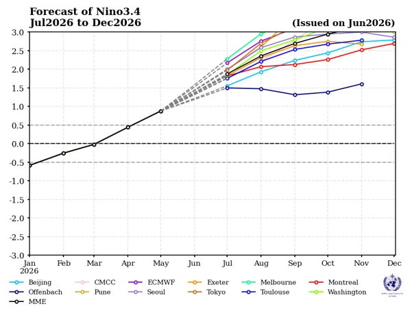
Meanwhile, the World Meteorological Organization (WMO) and the U.S. National Oceanic and Atmospheric Administration’s (NOAA) Climate Prediction Center (CPC) indicate that El Niño conditions are expected to persist and strengthen during the second half of 2026.
Current multi-model guidance suggests the event could become strong by autumn, although its eventual peak intensity remains uncertain.
The cold anomaly combined with the strengthening El Niño, could alter the position and strength of the jet stream during the early stages of Winter 2026–27.
Such changes may influence storm tracks and temperature patterns across parts of North America and Europe, although the precise regional impacts remain uncertain several months in advance.
Large-scale pressure patterns could favor a more amplified jet stream across the Northern Hemisphere, according to seasonal guidance from the European Center for Medium-Range Weather Forecasts (ECMWF).
Similar broad signals appear in other long-range forecasting systems, although individual models differ in the placement and intensity of regional temperature and precipitation anomalies.
ECMWF and other seasonal forecast systems show an increased probability of colder-than-average conditions across portions of the central and eastern U.S. during the early part of winter, while warmer-than-average conditions may prevail across western Canada and parts of the western U.S.
These projections represent seasonal probabilities rather than forecasts of individual cold outbreaks, winter storms, or snowfall events.
The evolving atmospheric pattern could also influence the distribution of winter storms across North America. Depending on how the Pacific jet stream and North Atlantic circulation develop during the season, some regions may experience increased storm activity while others remain comparatively mild. Frecasters note that confidence in regional details remains limited at this time.
ECMWF and other seasonal models indicate that the interaction between El Niño and the North Atlantic circulation could favor contrasting conditions between the northern and southern parts of Europe.
Some models suggest periods of enhanced Atlantic storm activity over northwestern Europe, while others indicate relatively milder conditions across portions of central and western Europe. Confidence in specific regional winter outcomes, however, remains lower than confidence in the broader large-scale climate signals.
Researchers are also closely monitoring the Atlantic cold anomaly because previous studies have associated similar sea-surface temperature patterns with changes in the North Atlantic Oscillation (NAO), one of the primary drivers of winter weather across Europe and eastern North America.
Updated seasonal outlooks issued during autumn are expected to provide greater confidence in regional temperature, precipitation, and storm-track projections as ocean temperatures, atmospheric circulation, and other climate indicators become better defined.
Although confidence is increasing that El Niño will become one of the dominant climate drivers heading into Winter 2026–27, meteorological agencies emphasize that seasonal outlooks should be interpreted as projections of probable climate patterns rather than forecasts of specific weather events.
References:
1 A Cold Atlantic Anomaly Returns as Super El Niño Shapes Winter 2026/2027 Early Forecast Signals – SWE – July 3, 2026
2 El Niño is forecast to intensify, increasing the likelihood of extreme weather – WMO – July 3, 2026

I am an Assistant Editor and Severe Weather & Science Journalist at The Watchers, specializing in real-time severe weather coverage, geophysical event reporting, and research-driven scientific analysis. You can reach me at rishav(at)watchers(.)news.

Commenting rules and guidelines
We value the thoughts and opinions of our readers and welcome healthy discussions on our website. In order to maintain a respectful and positive community, we ask that all commenters follow these rules.