
Rare Atlantic Niña develops as strengthening El Niño points to quieter 2026 Atlantic hurricane season
A rare Atlantic Niña has developed across the equatorial Atlantic while El Niño continues strengthening in the tropical Pacific. Although Atlantic Niña events are relatively uncommon, forecasters say the developing pattern could reinforce atmospheric conditions that typically suppress tropical cyclone formation across the Atlantic basin.
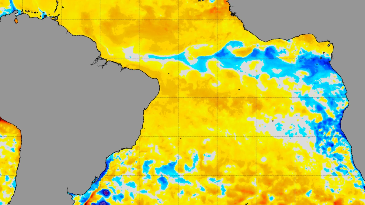
NOAA coral reef watch 5 km SST July 16, 2026 shows a developing cold anomaly in the Atlantic. Credit: NOAA
A rare Atlantic Niña has developed across the equatorial Atlantic while a rapidly strengthening El Niño continues to intensify in the tropical Pacific.
The combination of these opposing ocean temperature anomalies could influence atmospheric circulation over North America during the remainder of the 2026 Atlantic hurricane season and into the coming winter.
Atlantic Niña is characterized by below-average sea surface temperatures in the eastern equatorial Atlantic Ocean and typically develops during the Northern Hemisphere summer.
Sea surface temperatures across parts of the eastern equatorial Atlantic are currently between 1 and 3°C (1.8 to 5.4°F) below average. The broad area of cold anomalies is consistent with an Atlantic Niña event, according to an analysis by Andrej Flis of Severe Weather Europe.
“Atlantic Niña events are not unprecedented, but strong summer events are relatively rare. If the current cooling persists and the seasonal anomaly ends below −0.5°C (−0.9°F), the 2026 event would become only the sixth such Atlantic Niña in more than 40 years of historical data,” Andrej Flis od Severe Weather Europe said.
A strengthening “Super El Niño,” combined with the Atlantic Niña, could create an “atmospheric shield” over the United States by favoring conditions that suppress tropical cyclone development across the Atlantic basin.
During an Atlantic Niña, the number of tropical cyclones is about 50% lower than during an Atlantic Niño, including storms making landfall in the United States.
The developing Atlantic Niña may further reinforce changes in tropical convection by reducing thunderstorm activity over the eastern tropical Atlantic and modifying the position and strength of the Atlantic subtropical high. Together, these changes can reshape atmospheric circulation across the Atlantic basin and influence the environments through which tropical disturbances travel.
The Pacific component of this year’s climate pattern is already well established. NOAA announced in June that El Niño had officially developed and forecast that it would strengthen to at least moderate or strong intensity during the second half of 2026.
Current forecasts show exceptionally high confidence that El Niño will persist into early 2027, with an 81% probability of becoming a very strong event by late autumn and a 97% probability that El Niño conditions will continue through early spring 2027.
Strong El Niño events have historically been associated with fewer Atlantic hurricanes because they enhance vertical wind shear across the Main Development Region, where many long-track tropical cyclones originate.
El Niño also alters the Walker circulation across the tropical Pacific and strengthens upper-level westerly winds over the tropical Atlantic.
These stronger winds increase vertical wind shear—the change in wind speed and direction with height—which disrupts the organization of developing tropical cyclones and generally reduces Atlantic hurricane activity.
The effects are already reflected in NOAA’s below-normal outlook for the 2026 Atlantic hurricane season.
NOAA’s outlook for the 2026 Atlantic hurricane season, which runs from June 1 through November 30, gives a 35% probability of a near-normal season, a 10% probability of an above-normal season, and a 55% probability of a below-normal season.
The agency forecasts 8 to 14 named storms, with sustained winds of at least 63 km/h (39 mph). Of those, 3 to 6 are expected to become hurricanes, with sustained winds of at least 119 km/h (74 mph).
These include 1 to 3 major hurricanes (Category 3, 4, or 5) with sustained winds of at least 179 km/h (111 mph). NOAA assigns a 70% confidence to these ranges. An average season produces 14 named storms, including 7 hurricanes, of which 3 become major hurricanes.
“Although El Niño’s impact in the Atlantic basin can often suppress hurricane development, there is still uncertainty in how each season will unfold,” said National Weather Service (NWS) Director Ken Graham. “That is why it is essential to review your hurricane preparedness plan now. It only takes one storm to make for a very bad season.”
It is worth noting that the effects of interactions between Atlantic Niña and El Niño remain an active area of research because Atlantic Niña events are relatively rare.
Forecasters will continue monitoring both the rapidly strengthening Pacific El Niño and the unusually cool waters developing across the equatorial Atlantic.
References:
1 A Rare Atlantic Niña Emerges, Joins Super El Niño to Build an Atmospheric Shield for the U.S. – SWE – July 16, 2026
2 NOAA predicts below-normal 2026 Atlantic hurricane season – NOAA – May 21, 2026

I am an Assistant Editor and Severe Weather & Science Journalist at The Watchers, specializing in real-time severe weather coverage, geophysical event reporting, and research-driven scientific analysis. You can reach me at rishav(at)watchers(.)news.

Commenting rules and guidelines
We value the thoughts and opinions of our readers and welcome healthy discussions on our website. In order to maintain a respectful and positive community, we ask that all commenters follow these rules.