
Flood threat expands along Gulf Coast as Potential Tropical Cyclone One nears Louisiana
Heavy rainfall, flash flooding, storm surge, and isolated tornadoes are expected across portions of the Gulf Coast as Potential Tropical Cyclone One tracks along the Texas coast on June 17, 2026. While the system is unlikely to develop into a tropical cyclone, it could bring rainfall totals of up to 500 mm (20 inches) to some areas along with the severe weather.
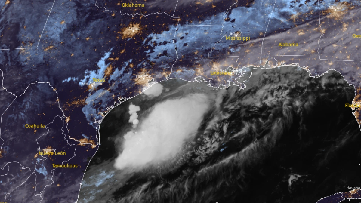
Satellite image of Potential Tropical Cyclone 1 at 09:00 UTC on June 17, 2026. Credit: NOAA/GOES-19, RAMMB/CIRA, The Watchers
Potential Tropical Cyclone One is bringing the threat of potentially life-threatening flash flooding across parts of the Gulf Coast and Southeast United States, as it moves northeastward along the Middle Texas coast.
At 04:00 CDT (09:00 UTC), the system was located about 55 km (35 miles) southwest of Port O’Connor, Texas, and 410 km (255 miles) southwest of Lake Charles, Louisiana. It was moving northeast at 9 km/h (6 mph) with 1-minute maximum sustained winds of 45 km/h (30 mph) and a minimum central pressure of 1 003 hPa.
The National Hurricane Center (NHC) forecasts rainfall totals of 125 to 250 mm (5 to 10 inches) for portions of the Mid and Upper Texas coast east-northeast into Louisiana, Mississippi, Alabama, western Georgia, and the Florida Panhandle through early June 19. Isolated totals of up to 500 mm (20 inches) of rain remain likely.
Forecasters warned that potentially life-threatening flash flooding and urban flooding are likely through June 18, with ongoing heavy rainfall capable of extending the flood threat into the weekend.
“The interaction between the tropical moisture associated with PTC1 and the fast-moving weather pattern to the north continues to support a multiday heavy rainfall event across the Gulf Coast states,” the Weather Prediction Center said.
Tropical Storm Warnings remain in effect from Sabine Pass, Texas, to Morgan City, Louisiana, while a Tropical Storm Watch covered the coastline from Sargent, Texas, to Sabine Pass.
Storm surge was forecast to raise water levels 0.6 to 1.2 m (2 to 4 feet) above normally dry ground from Port Bolivar, Texas, to Morgan City, Louisiana, if peak surge coincided with high tide.
The worst flooding could occur near and east of the system’s landfall location, where large and dangerous waves are expected. Minor to moderate coastal flooding was also forecast along portions of the Upper Texas and Louisiana coasts.
A couple of tornadoes are possible through June 18 from the Upper Texas Coast into southern Louisiana, Mississippi, Alabama, and the western Florida Panhandle. Dangerous surf and rip current conditions were also expected along portions of the northwestern Gulf Coast.
While the system is triggering severe weather across the southern states, it is unlikely to develop into a tropical storm.
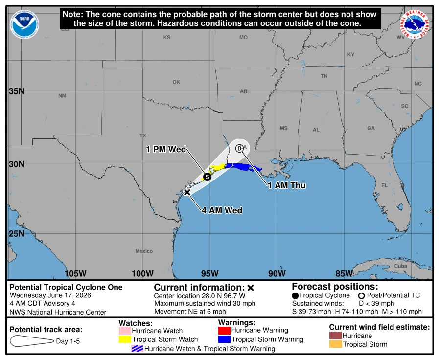
The forecast track called for the low-pressure area to continue moving along the Texas coast before shifting inland over southwestern Louisiana by the evening of June 17. Forecasters said the circulation was unlikely to remain over Gulf waters long enough to organize significantly.
Despite those unfavorable conditions, the NHC forecasts a 60% probability of tropical cyclone formation during both the next 48 hours and the next seven days.
References:
1 Potential Tropical Cyclone One Discussion Number 4 – NOAA/NHC – June 17, 2026
2 Potential Tropical Cyclone One Advisory Number – NOAA/NHC – June 17, 2026
3 Short Range Forecast Discussion – NWS/WPC – June 17, 2026

I am an Assistant Editor and Severe Weather & Science Journalist at The Watchers, specializing in real-time severe weather coverage, geophysical event reporting, and research-driven scientific analysis. You can reach me at rishav(at)watchers(.)news.
What is the difference between a Tropical Storm and a Tropical Cyclone?