
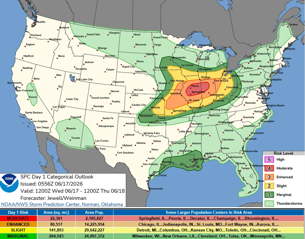
SPC issues Moderate Risk for severe storms from Missouri to Indiana, tornadoes and destructive winds possible
A Moderate Risk (Level 4 of 5) for severe thunderstorms has been issued for parts of Indiana and Illinois through June 17, 2026. Wind gusts of over 120 km/h (75 mph), damaging hail and multiple tornadoes are forecast across the region as the storm system moves through the Midwest.
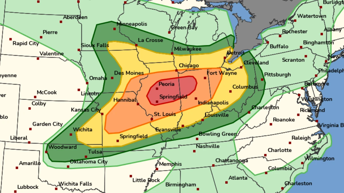
Image credit: NOAA/SPC
The Storm Prediction Center (SPC) has placed portions of Illinois and Indiana under a Moderate Risk (Level 4 of 5) for severe thunderstorms on June 17.
Several intense tornadoes, damaging wind gusts of over 120 km/h (75 mph), and damaging hail are possible as a powerful storm system moves across the Midwest.
The Moderate Risk area covers portions of Illinois and Indiana, while severe weather threats extend into parts of Missouri, Iowa, Ohio, and neighboring states.
An intense mid- and upper-level jet is forecast to overspread the Midwest, with a leading disturbance moving from Iowa into Illinois through the morning hours.
Forecasters expect this feature to support an initial round of severe thunderstorms capable of producing damaging winds across eastern Iowa and northern and central Illinois.
A strengthening southwesterly low-level jet is forecast to reach approximately 110 km/h (60 kt), rapidly transporting warm, moisture-rich air into the region. This influx of instability is expected to support organized severe convection during the day, while remnants of the morning thunderstorms move eastward into Indiana.
Farther east, a warm front is expected to lift northward through Indiana and Ohio. Forecasters indicate that new thunderstorms may develop along and north of this boundary or evolve from residual convective activity moving out of Illinois.
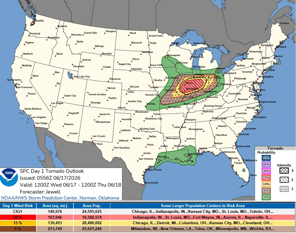
Wind profiles across the region are forecast to be exceptionally strong, creating an environment favorable for rotating thunderstorms capable of producing tornadoes if sufficient instability develops. The SPC notes that isolated tornadic supercells may form across northern Indiana and northwestern Ohio.
The greatest concern for severe weather extends from northern Missouri through Illinois into central and western Indiana. Strong southwesterly flow is expected to transport a corridor of Gulf moisture northward, with dew point temperatures forecast to reach 18 to 21°C (65 to 70°F).
Combined with daytime heating and strong wind fields throughout the lower and middle atmosphere, conditions are expected to support rapid destabilization during the afternoon and evening.
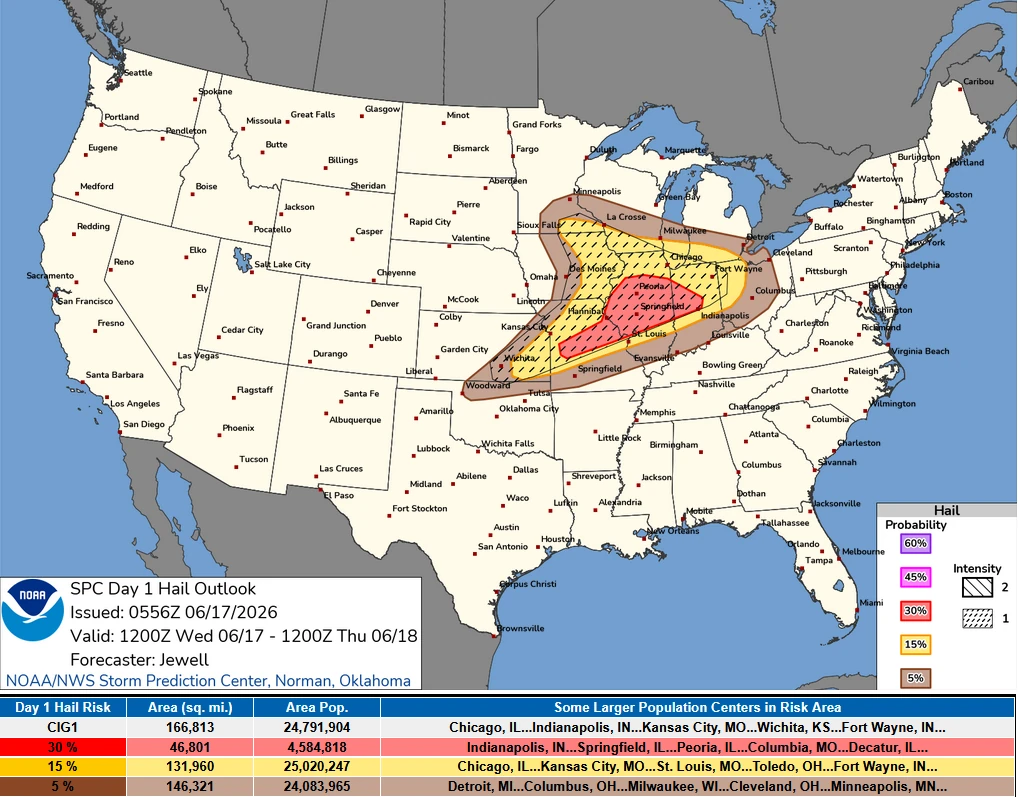
In addition to the tornado threat, forecasters are monitoring the potential for severe thunderstorms to evolve into fast-moving bowing segments capable of producing widespread damaging winds.
Wind gusts exceeding 120 km/h (75 mph) may occur within the most intense storms, creating the potential for widespread damaging winds across portions of the Moderate Risk area.
The severe weather threat is expected to continue through the afternoon and evening before shifting eastward overnight. Residents across Illinois, Indiana, and surrounding states should closely monitor forecasts, watches, and warnings issued by the National Weather Service throughout the day as conditions evolve.
References:
1 Day 1 Convective outlook – SPC – June 17, 2026

I am an Assistant Editor and Severe Weather & Science Journalist at The Watchers, specializing in real-time severe weather coverage, geophysical event reporting, and research-driven scientific analysis. You can reach me at rishav(at)watchers(.)news.
Commenting rules and guidelines
We value the thoughts and opinions of our readers and welcome healthy discussions on our website. In order to maintain a respectful and positive community, we ask that all commenters follow these rules.