
Weak La Niña to end as ocean warming signals new El Niño phase in 2026
Forecast models suggest that El Niño conditions are likely to develop during 2026, marking a shift from the ongoing weak La Niña. The transition is expected to influence jet stream patterns and temperature anomalies across the United States, Canada, and Europe, potentially reshaping rainfall distribution and winter storm activity in the Northern Hemisphere.

Image credit: NASA
Current long-range climate outlooks indicate that the tropical Pacific is moving toward a new El Niño phase in 2026, following the current weak La Niña phase.
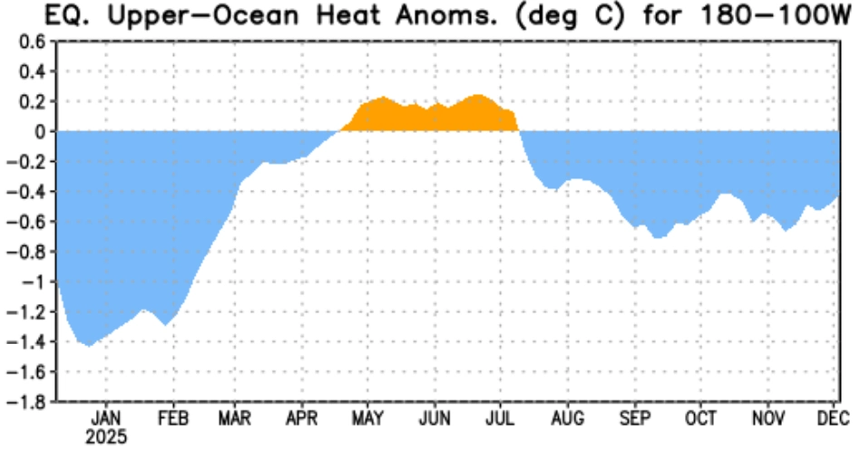
Seasonal forecast systems, including the European Centre for Medium-Range Weather Forecasts (ECMWF), show a gradual warming of central and eastern equatorial Pacific sea-surface temperatures through mid-2026. If this persists, El Niño could strengthen during the second half of the year and extend into the 2026/2027 ENSO cycle.
El Niño and La Niña represent opposite phases of the El Niño–Southern Oscillation (ENSO), which is a major driver of global climate.
While La Niña features below-average sea-surface temperatures in the equatorial Pacific, El Niño is characterized by sustained ocean warming that disrupts atmospheric circulation across the tropics and mid-latitudes. These temperature fluctuations affect the position and strength of the Pacific jet stream, producing systematic patterns of precipitation and temperature anomalies across continents.
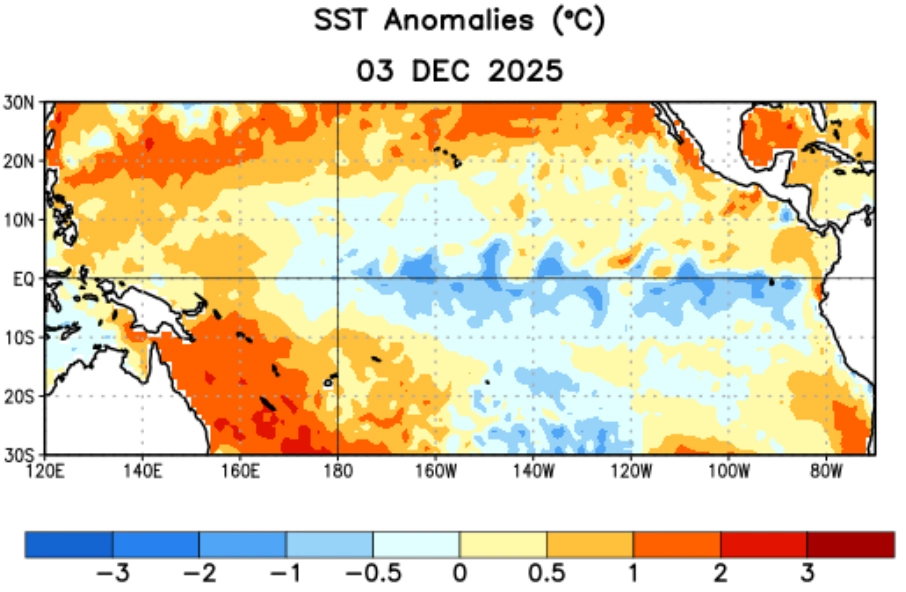
In late 2025, atmospheric conditions still show La Niña influence, with enhanced trade winds and cooler-than-normal tropical Pacific waters. This configuration led to colder winter outbreaks across parts of North America, intensified snowfalls in interior Canada, and stronger polar vortex interactions over the Northern Hemisphere.
However, ocean-atmosphere coupling is expected to weaken during the first half of 2026, allowing surface warming to emerge in the central Pacific. If El Niño fully develops, its impacts on the United States and Canada are expected to include significant changes to jet stream alignment.
Historically, El Niño winters produce a stronger, more zonal Pacific jet stream, steering storms across the southern and eastern U.S. and bringing above-average precipitation to the Gulf Coast and Southeast regions.
Northern states and western Canada generally experience milder, drier conditions compared with La Niña winters, while southern Canada and the Great Lakes region may see periods of enhanced storm activity.
Forecast confidence remains moderate. ENSO predictions made more than six months ahead carry substantial uncertainty due to model divergence and the complexity of ocean-atmosphere feedbacks.
Nonetheless, the persistence of sub-surface warm anomalies and weakening trade winds support a transition toward positive ENSO conditions by mid-2026.
Monitoring by the National Oceanic and Atmospheric Administration (NOAA) and the World Meteorological Organization (WMO) will continue through the first half of the year to confirm the onset and strength classification once sea-surface anomalies exceed 0.5°C (32.9°F) for a sustained period.
References:
1 El Niño Watch 2026: Latest Forecasts Show El Niño Returning with Global Weather Impacts – SWE – December 15, 2025
2 El Niño/Souther Oscillation (Enso) Diagnostic Discussion – NOAA/CPC – December 11, 2025

I am an Assistant Editor and Severe Weather & Science Journalist at The Watchers, specializing in real-time severe weather coverage, geophysical event reporting, and research-driven scientific analysis. You can reach me at rishav(at)watchers(.)news.
Commenting rules and guidelines
We value the thoughts and opinions of our readers and welcome healthy discussions on our website. In order to maintain a respectful and positive community, we ask that all commenters follow these rules.