
The role of ENSO in shaping global rainfall, storms and temperature patterns
The El Niño–Southern Oscillation (ENSO) is one of the primary drivers of year-to-year climate variability, influencing rainfall, monsoons, heat extremes and storm patterns worldwide. Late 2025 observations indicated a weak La Niña, with many climate models projecting a transition toward neutral conditions early in 2026.

Image credit: NNVL
ENSO shapes atmospheric circulation on a global scale because temperature anomalies in the central Pacific influence where heat and moisture rise into the atmosphere. When convection zones shift east or west, they change how energy is distributed across the planet. These changes alter the position of planetary-scale waves that guide storm tracks in both hemispheres.
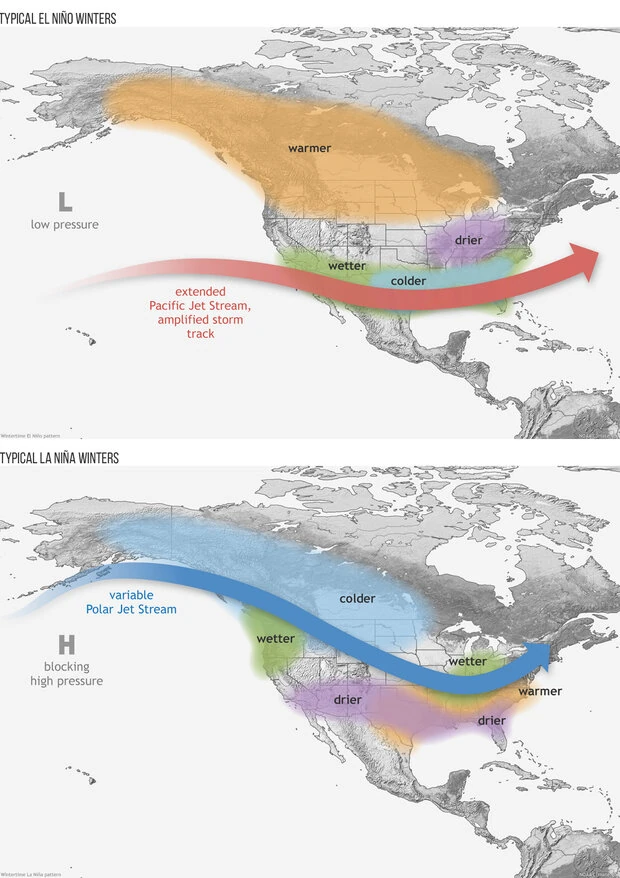
The strength and location of the subtropical jet stream often respond to ENSO conditions. During many El Niño events, the jet stream strengthens and shifts, bringing wetter winters to parts of the southern United States and influencing storm behavior in East Asia and Europe. During La Niña, the jet can weaken or shift, altering rainfall distribution across the subtropics and midlatitudes.
Regions with monsoon-driven rainfall are particularly sensitive to these shifts. South Asia, East Africa, and parts of South America rely on seasonal monsoon systems that can strengthen or weaken depending on the ENSO phase. Reduced convection in certain areas during El Niño can weaken monsoons, while enhanced convection during La Niña can amplify them.
ENSO also influences high-latitude circulation. By affecting upper-atmospheric wave patterns, ENSO can increase the likelihood of colder or milder winters across the Northern Hemisphere, depending on regional interactions with other climate modes. These effects vary by event but contribute to broader seasonal tendencies.
The scale of these atmospheric adjustments is why ENSO influences everything from local drought risk to large-scale storm sequences. It forms the backbone of many seasonal forecasts issued for agriculture, disaster risk reduction, and water management.
What ENSO is and how scientists identify its phases
ENSO is a coupled ocean–atmosphere system defined by interactions among sea surface temperatures, atmospheric pressure patterns, and trade wind strength. Its phases shift as the ocean and atmosphere reinforce or weaken each other, producing irregular oscillations that recur every two to seven years.
The most widely used monitoring index is the Niño 3.4 region, which averages sea surface temperature anomalies over a section of the central Pacific. A three-month running mean greater than about +0.5°C usually signals El Niño, while values below about −0.5°C indicate La Niña. These thresholds help ensure that short-term weather fluctuations do not trigger false classifications.
Atmospheric indicators complement sea surface temperature observations. The Southern Oscillation Index measures changes in atmospheric pressure between Tahiti and Darwin. When pressure differences shift consistently, they confirm whether the atmosphere is responding to the underlying ocean anomalies and whether a phase transition is underway.
ENSO neutral occurs when temperatures remain near average. These periods often feature complex regional climate behavior because other climate modes, such as the Indian Ocean Dipole or Arctic-related patterns, become more influential. Forecast accuracy during neutral phases can be lower because ENSO does not provide a dominant global signal.
Scientists track ENSO continuously using satellites, ocean buoys, ship-based observations, and profiling floats. This global observing network allows agencies to detect early warning signs of phase changes and issue probabilistic forecasts months in advance.
How ENSO works beneath the surface
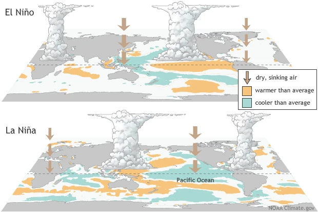
ENSO is driven by a feedback loop in which trade winds, sea surface temperatures, and ocean upwelling reinforce one another. Under normal conditions, the trade winds push warm surface water westward, piling it up in the western Pacific and allowing cooler water to rise from depths of more than 100 m (330 feet) in the east. This pattern produces a strong temperature contrast that supports the Walker circulation.
When the trade winds weaken for several weeks, the warm pool shifts eastward. Upwelling decreases along the South American coast, allowing the upper ocean to warm. As sea surface temperatures rise, atmospheric convection shifts eastward, further weakening the winds. This positive feedback leads to El Niño.
If the trade winds strengthen instead, colder water rises to the surface more efficiently, producing La Niña. The temperature gradient becomes steeper and convection shifts toward the western Pacific. This pattern enhances the Walker circulation and maintains the cool phase.
Subsurface ocean dynamics help control phase transitions. Eastward-moving Kelvin waves transport warm anomalies across the Pacific, often marking the onset of an event. Westward-moving Rossby waves and thermocline adjustments help terminate events by redistributing heat. These processes explain why ENSO can change rapidly after appearing stable for months.
The thermocline’s shape influences how heat is stored and released. A deeper thermocline during El Niño reduces the amount of cold water reaching the surface, while a shallower thermocline during La Niña cools the surface quickly. The role of the thermocline makes subsurface observations critical for early prediction.
How the ENSO phases affect weather around the world
El Niño brings warmer waters to the central and eastern Pacific. On average, this leads to wetter winters in the southern United States, increased rainfall along the Pacific coast of South America, and reduced rainfall in Australia and Indonesia. These impacts arise because tropical convection shifts eastward, changing where rising air drives storm formation.
El Niño often alters the behavior of tropical cyclones. Increased vertical wind shear in the Atlantic tends to reduce hurricane formation, while the eastern Pacific may see increased cyclone activity. These responses vary from event to event because local atmospheric conditions can amplify or diminish ENSO’s influence.
La Niña creates the opposite pattern. Cooler central Pacific waters shift convection westward, favoring wetter conditions in Indonesia, northern Australia, and parts of East Africa. The southern United States often becomes drier. In the Atlantic, reduced wind shear supports the development of more frequent tropical cyclones.
ENSO-neutral periods are characterized by weaker Pacific forcing. When the Pacific remains near its long-term average, other climate patterns become more prominent, making seasonal forecasts more challenging. Outcomes can be influenced by the Indian Ocean Dipole, Arctic circulation shifts, or regional sea surface temperature anomalies.
The strength of an ENSO event influences its global footprint. Strong El Niño or La Niña events can affect rainfall across several continents, increase flood or drought risk, and alter storm frequencies. Weaker events produce more modest but still meaningful shifts in climate patterns.
Why ENSO influences food security, oceans, and society
ENSO drives major swings in agricultural outcomes. Regions prone to drought during El Niño or La Niña use seasonal forecasts to adjust planting dates and crop choices. Crops such as maize, rice, and wheat respond differently depending on local rainfall patterns, which influence global food supply and market prices.
Marine ecosystems depend on upwelling processes that change during ENSO phases. El Niño reduces nutrient availability along the South American coast, affecting fish populations such as anchoveta. Coral reefs across the Pacific face higher thermal stress during warm events. La Niña often restores nutrient-rich upwelling and increases biological productivity.
Humanitarian consequences can escalate during strong ENSO phases. El Niño-related droughts have contributed to food insecurity in regions such as southern Africa. La Niña-related flooding has displaced communities in Southeast Asia and East Africa. Relief agencies use ENSO forecasts to prepare early interventions.
Energy production and water management are closely tied to ENSO. Hydropower systems rely on predictable rainfall and streamflow. ENSO-driven anomalies can reduce reservoir inflow or increase it beyond planned levels. Snowpack-dependent regions experience altered water availability when winter precipitation is shifted by ENSO.
Public health outcomes shift with ENSO-related climate anomalies. Mosquito-borne diseases respond to changes in rainfall and temperature. Some regions experience an increased risk of dengue or malaria during specific ENSO phases due to changes in breeding conditions.
How predictable ENSO is and why forecasts matter
ENSO offers relatively high predictability compared to many other climate systems because warm or cool anomalies often persist for several months. Seasonal forecasting centers use this stability to anticipate regional impacts and issue outlooks well before critical seasons begin.
Dynamical models simulate the ocean and atmosphere to project how the Pacific will evolve. These models draw on satellite observations, buoy networks, and deep ocean profiling systems. Statistical models analyze historical data to estimate how current conditions resemble past events.
Forecast skill is not uniform throughout the year. The period from March to May is known as the spring predictability barrier because ENSO becomes harder to forecast. During this time, the Pacific responds more strongly to short-term atmospheric variability, reducing model agreement.
Forecasts are expressed as probabilities. Agencies estimate the likelihood of El Niño, La Niña, or neutral conditions for future seasons. Users are encouraged to interpret these probabilities as ranges of possible outcomes rather than fixed predictions.
Regional climate impacts depend on the interaction between ENSO and other climate drivers. Two El Niño events can produce different regional outcomes depending on how they interact with local atmospheric conditions. This complexity underscores the need for ongoing updates.
What happened during the 2024 to 2025 ENSO cycle
Late 2025 monitoring showed a weak La Niña underway. Sea surface temperatures in the Niño 3.4 region were slightly below average, and trade winds were occasionally stronger than normal. These conditions supported periodic upwelling along the South American coastline and maintained the cool phase.
Model ensembles suggested that this weak La Niña would persist in the short term. Many projections indicated a gradual return to neutral conditions early in 2026. Subsurface warming at depth suggested that the cool anomalies were weakening.
The event’s modest intensity produced moderate global effects. Southeast Asia experienced wetter conditions typical of La Niña, while the southern United States saw drier periods. Other regions displayed mixed signals because additional climate drivers shaped local weather.
The approach of the spring predictability barrier increased uncertainty surrounding early 2026 outlooks. Climate agencies stressed the importance of updated assessments as new observations became available.
Seasonal risk managers, agricultural planners, and emergency agencies were encouraged to track forecast updates closely. Even weak ENSO events can interact with regional patterns to produce significant impacts, making continuous monitoring essential.
References:
1 What is the El Niño–Southern Oscillation (ENSO) in a nutshell? – NOAA – May 5, 2024
2 ENSO Forecast – IRI – November 19, 2025

I’m a science journalist and researcher at The Watchers, contributing to the Epicenter edition, where I cover peer-reviewed scientific research and emerging discoveries across Earth and space sciences. With a background in astronomy and a passion for environmental science, I’ve worked in shark and coral conservation in Fiji, conducting reef and shark-behavior research, contributing to mangrove restoration, and earning PADI Open Water and Coral Reef Certifications. I bring a blend of scientific rigor and storytelling to illuminate the discoveries shaping our planet and beyond.
Commenting rules and guidelines
We value the thoughts and opinions of our readers and welcome healthy discussions on our website. In order to maintain a respectful and positive community, we ask that all commenters follow these rules.