
One dead, hundreds of thousands without power after tornadoes and severe storms hit Midwest and Northeast
Severe storms that produced damaging tornadoes outside Chicago killed one person in Iowa, damaged communities in Illinois and Indiana, and left hundreds of thousands without power across the Midwest and Northeast on Thursday, June 11, 2026. As of 03:00 CDT (08:00 UTC) on Friday, more than 650 000 customers were without power across 8 states, including at least 250 000 in Illinois and 170 000 in Indiana.
Severe storms and tornadoes damaged communities in Illinois and Indiana on Thursday, June 11, tearing roofs from buildings, downing trees and power poles, blocking roads, and leaving over 680 000 customers without power across 8 U.S. states early Friday. The largest outage totals were reported in Illinois, Indiana, and Michigan, while storm impacts extended from the Midwest into parts of the Northeast.
At 03:00 CDT (08:00 UTC), PowerOutage reported 253 424 customers without service in Illinois, 178 161 in Indiana, 95 456 in Michigan, 33 586 in Virginia, 18 474 in Ohio, 18 286 in Wisconsin, and 18 272 in Pennsylvania.
At least three tornadoes battered communities outside Chicago, damaging homes, toppling trees and power poles, and disrupting flights. In Merrillville, Indiana, downed trees and power lines blocked streets, homes were damaged, and part of a high school roof was torn away. In Streator, Illinois, officials opened a reunification center and Red Cross shelter after tornado damage, while Mayor Tara Bedei said there were no reported deaths there.
The Storm Prediction Center’s (SPC) storm-report database for June 11 shows tornadoes extended from central Illinois into northwest Indiana. Reports included a large tornado near Streator at 22:42 UTC, structural damage on the south side of Streator at 22:51 UTC, tornadoes east of Streator and near Ransom and Dwight, and later tornado reports near Hebron, Boone Grove, Kouts, and Wanatah in Indiana.
Reports from northwest Indiana showed roof damage to Andrean High School in Merrillville and broken large branches nearby. Farther east, a house shifted off its foundation, and windows were blown out near Wabash, Indiana, with several trees down in the area.
The Des Moines police said a 54-year-old man died after a tree broke apart and fell during strong storms in Iowa. Local reports said first responders found him at a homeless encampment on the 3300 block of Martin Luther King Jr. Parkway in Des Moines’ Prospect Park neighborhood around 08:00 LT on June 11.
NIPSCO, the Northern Indiana electric and natural gas utility, said severe storms brought rain, lightning, damaging winds and multiple tornadoes that touched down across portions of its service territory on June 11, causing widespread power outages. The utility reported more than 45 000 customers without power after about 95% of 21 500 customers affected by the previous day’s storm had been restored before Thursday’s storms began.
The company said it could not determine a restoration estimate at that time and warned customers to stay away from downed power lines, damaged poles, and other hazardous situations. The restoration will begin with large transmission and distribution lines serving the largest numbers of customers, including critical customers such as hospitals and emergency response.
SPC wind reports included a semi-truck blown over and multiple vehicles in a ditch near Deer Creek, Illinois, another semi-truck blown over near the I-74/I-55 interchange southwest of Bloomington, two broken power poles near Waynesville, and six snapped power poles west of Rantoul. Wind gusts of 115 km/h (70 mph) were reported west of Washington, Illinois, about 115 km/h (72 mph) south of Ames, Iowa, and about 120 km/h (75 mph) in Illinois.
The June 11 tornadoes followed a destructive windstorm one day earlier that FOX Weather described as a 560 km (350 miles) derecho across the Midwest. FOX Weather reported that its Forecast Center confirmed the system as a powerful derecho that started in Iowa before moving through Illinois, Wisconsin, Michigan and Indiana, knocking out power to at least 500 000 customers and producing gusts above 130 km/h (80 mph) across Illinois and Wisconsin, including 151 km/h (94 mph) at Oshkosh, Wisconsin.
Ground stops were reported at Chicago O’Hare International Airport, Midway International Airport, and John F. Kennedy International Airport at various points on Wednesday and Thursday, with more than 1 000 flights into and out of Chicago delayed or canceled, according to FlightAware.
SPC’s Day 2 outlook placed an Enhanced Risk from eastern Kansas into west-central Illinois for Saturday, June 13, into early Sunday, June 14, with one or more bowing mesoscale convective systems expected and isolated gusts of 115–130 km/h (70–80 mph) possible.
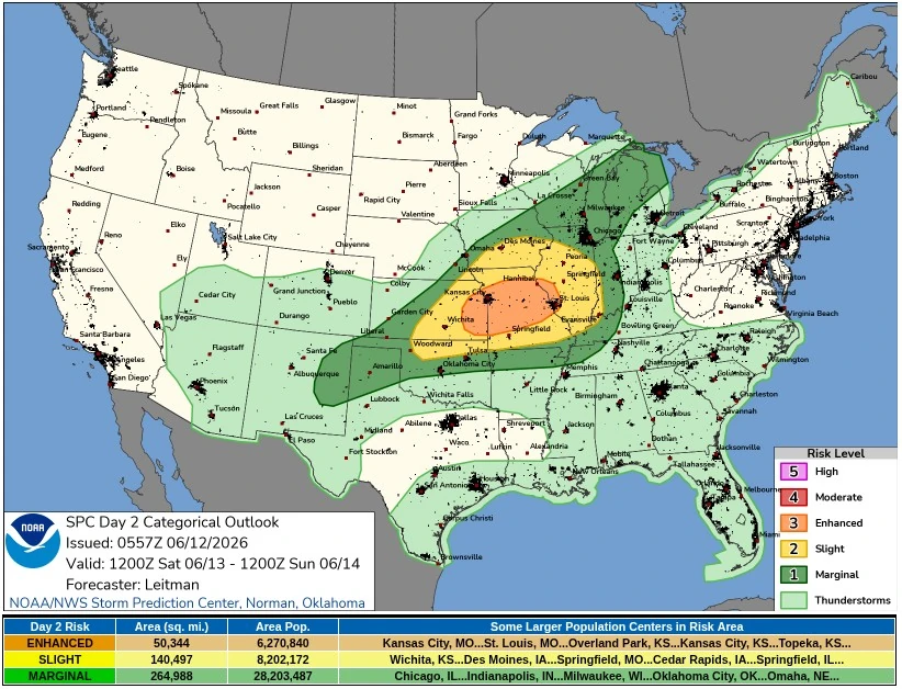
One or two thunderstorm clusters may develop across parts of the central Great Plains and lower Missouri Valley from Saturday afternoon through Saturday night, June 13 into early June 14, with strong damaging wind gusts as the primary hazards, according to SPC. Large to very large hail is also possible early in storm development from Kansas into Iowa, before storms organize into one or more bowing mesoscale convective systems (MCSs).
Storm development is most likely near the surface front from eastern Kansas into Iowa during the afternoon. Initial supercells are possible, with large to very large hail favored early because of steep lapse rates, strong instability, and elongated forecast hodographs. Low-level shear is expected to remain modest, but the combination of rich moisture and strong instability could still support a couple of tornadoes.
By late afternoon and evening, storms are expected to grow upscale as the surface front moves southeast, with one or more bowing MCSs posing a scattered damaging-wind threat. Isolated gusts of 115–130 km/h (70–80 mph) are possible as the activity moves southeast across the lower Missouri Valley toward the Ozarks through the evening and overnight.
Farther north, isolated thunderstorms are expected near Lake Michigan along the advancing cold front during the afternoon and early evening. Across the southern Plains, isolated to scattered storms may form near a dryline from southwest Kansas into eastern New Mexico, where deep mixing and temperatures in the 30s°C (90s°F) will favor higher-based storms capable of isolated strong wind gusts and some hail.
References:
1 NWS Local Storm Reports – NWS/SPC – June 12, 2026
2 Day 2 Convective Outlook – NWS/SPC – June 12, 2026
Featured image: Tornado near Farnum, Nebraska, in 2019. Credit: Morgan Schneider, OU CIMMS/NOAA NSSL
I'm a dedicated researcher, journalist, and editor at The Watchers. With over 20 years of experience in the media industry, I specialize in hard science news, focusing on extreme weather, seismic and volcanic activity, space weather, and astronomy, including near-Earth objects and planetary defense strategies. You can reach me at teo /at/ watchers.news.
Commenting rules and guidelines
We value the thoughts and opinions of our readers and welcome healthy discussions on our website. In order to maintain a respectful and positive community, we ask that all commenters follow these rules.