
Flash flooding prompts emergency declarations and evacuations in western Manitoba, Canada
Up to 150 residents were displaced after flash flooding struck communities across western Manitoba, Canada, following an extreme rainfall event that dropped nearly 150 mm (6 inches) of rain in parts of the Swan Valley region from late June 7 into the early hours of June 8, 2026. Local authorities declared states of emergency as floodwaters damaged roads, washed out sections of Highways and bridges, and threatened dam failure near Harvey Lake.
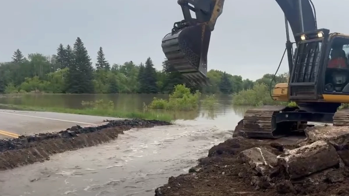
Section of Highway 10 being cut to control flooding of Swan River in Minitonas, Manitoba on June 9, 2026. Credit: Lance Jacobson
Up to 150 residents were displaced after flash flooding struck communities in western Manitoba following an extreme rainfall event that dropped nearly 150 mm (6 inches) of rain within a few hours in some areas from late June 7 into the early hours of June 8.
The heaviest rainfall was reported in Minitonas, a community in the Swan Valley region, approximately 370 km (230 miles) northwest of Winnipeg, where up to 148 mm of rain fell through the night of June 7 into the morning of June 8. The rainfall produced flash flooding across parts of Swan Valley West and neighboring communities.
Swan Valley West declared a local state of emergency as conditions deteriorated. The town of Swan River also issued an emergency declaration due to a potential dam break in the Alpine Area, which holds back Harvey Lake.

“Flooding is affecting communities across the Parkland and Swan Valley region, and severe weather warnings are in effect in parts of southern Manitoba,” said Premier Wab Kinew.
Premier Kinew reported that the flooding had reached a point where authorities had to cut the highway to let the water through and control flooding in the Swan River.
“We’ve got a few feet of dam left there before it fails. Should it fail, that entire lake will drain into the Roaring River system, which will then further increase flood levels in Swan River Valley,” area reeve Bill Gade said.
“The water is already over the top here, and the highway may fail on its own. But we’re going to do that in a controlled way … just to relieve the pressure,” Gade added. “We’ve got a lot of homes and businesses in Swan River being flooded, and we need to get the water down.”
Multiple roads and bridges in Minitonas were severely damaged, including a section of Highway 83 that was completely washed out.
Minitonas resident Peter Fleming says there’s a “sense of panic” in the community on June 9, with flooding that’s made cellphone service unreliable and cut off power, along with water being turned off in the area.
“It’s kind of like a war zone, I’ve got people actually standing out on my street right now because there’s one spot where you can get a little bit of service … coming off of another tower,” Fleming said.

Manitoba Transportation and Infrastructure’s Hydrologic Forecast Centre continues to monitor flood activity as another precipitation system is expected to move across the province beginning the evening of June 10 and continuing through June 12.
Forecasters said western Manitoba, including the Parkland region, and southeastern Manitoba, including the Whiteshell lakes area, could receive up to 70 mm (2.8 inches) of additional rainfall.
Meanwhile, most other areas of southern, eastern, and central Manitoba, including the Interlake region, could receive between 30 and 50 mm (1 and 2 inches). Some forecast models also indicate thunderstorms could produce localized rainfall totals exceeding 70 mm (3 inches).

A Flood Warning remains in effect for western Manitoba, including the Parkland region, while an overland flood watch has been issued for parts of western, central and southeastern Manitoba outside areas already under flood warning.
Officials said overland flooding occurs when high-intensity rainfall generates runoff that exceeds the capacity of ditches, drains and natural waterways, causing water to flow across normally dry areas. Residents are advised to monitor conditions closely and prepare for localized flooding, road washouts, and water accumulation in low-lying areas.
The Manitoba Emergency Management Organization continues to work with local authorities and emergency management partners to support response and recovery efforts. Several communities across the province remain affected by high water levels, with reported impacts including flooded properties, damaged infrastructure, and loss of road access. Authorities urged residents to watch for road closures, obey all detours, and avoid traveling on closed roads.
Damage assessments were continuing as emergency crews worked to restore access, evaluate transportation infrastructure, and monitor ongoing flood conditions. Flood forecasters continue to monitor precipitation amounts and assess impacts on flows and water levels.
References:
1 Spring Flood Bulletin #5 – Government of Manitoba – June 9, 2026
2 ‘Like a war zone,’ resident says as western Manitoba flooding washes out roads, cuts off power – CBC – June 10, 2026

Rishav Kothari is Editor-in-Chief of The Watchers, where he runs the newsroom and covers earthquakes, volcanoes, severe weather and space weather.
Published in the last 24 hours
- Hawaii's largest freshwater lake was 200 feet deep at 10 a.m. on June 2, 2018. By that afternoon, lava from Kilauea had boiled it away Epicenter
- Flying glass cut a teacher in Russia but none of her 44 pupils, because when a meteor flashed across the sky in 2013, she told them to get under their desks Epicenter
- A South Dakota man put the widest and heaviest hailstone on US record in his freezer, and a power cut melted part of it before NOAA measured it at 8 inches across and nearly 2 pounds in 2010 Epicenter
- Black kites and brown falcons in northern Australia have been seen snatching smoldering sticks from wildfires, flying them into unburned grass and dropping them, starting new fires that send lizards, rodents and insects running straight toward the waiting birds Epicenter
