
Severe thunderstorm outbreak forecast across Midwest and Great Lakes
A severe thunderstorm outbreak is forecast across parts of the Midwest and Great Lakes this afternoon and evening, with the highest risk focused on northern Illinois, far eastern Iowa, and far southern Wisconsin.
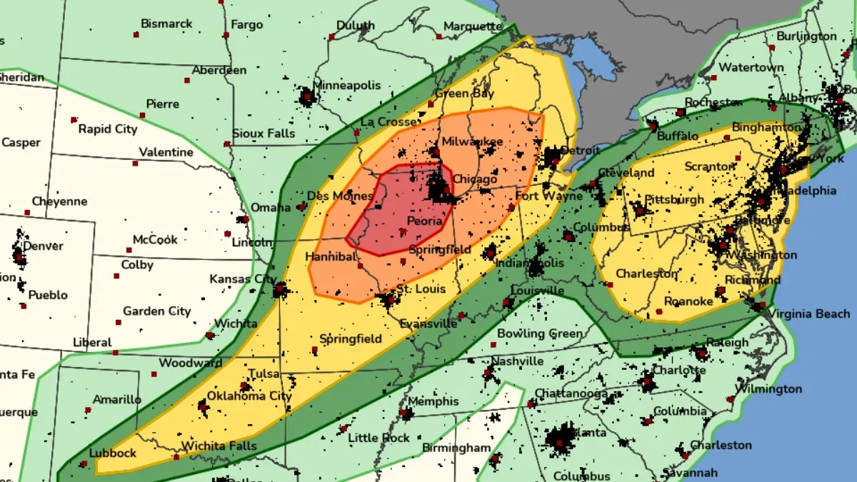
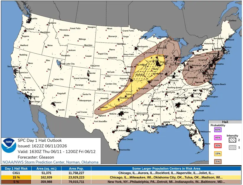
Day 1 Convective Outlook valid from 16:30 UTC on June 11 to 12:00 UTC on June 12, 2026. Credit: NWS/SPC
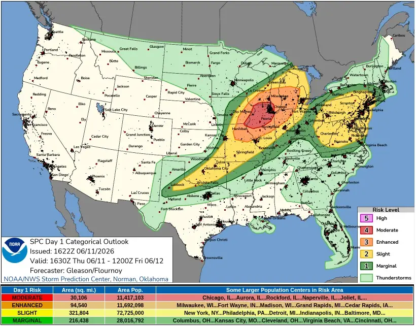
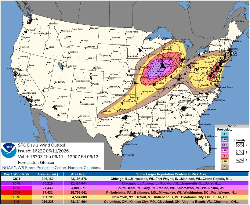
The Storm Prediction Center (SPC) issued a Moderate Risk for severe thunderstorms across northern Illinois, far eastern Iowa, and far southern Wisconsin on June 11, as an outbreak-level severe weather setup develops across parts of the Midwest and Great Lakes. Widespread damaging winds, large hail, and several tornadoes, some strong to intense, are forecast this afternoon and evening.
SPC’s updated Public Severe Weather Outlook, issued at 16:30 UTC, places far eastern Iowa, northern and central Illinois, southern Wisconsin, northern Indiana, northern Missouri, and Lower Michigan as the main exposed areas. The agency warned of widespread damaging winds, some hurricane force, several tornadoes with a couple intense, and isolated large hail up to baseball size.
Widespread severe thunderstorms are expected from far eastern Iowa, northern Missouri, northern and central Illinois, and southern Wisconsin into Lower Michigan and northern Indiana, with damaging winds over 120 km/h (75+ mph), large hail, and several tornadoes, some strong to intense.
According to SPC, an ongoing bowing cluster across southeastern Iowa, northwestern Illinois, southwestern Wisconsin, and nearby areas may continue to pose at least some severe wind threat and a threat for embedded tornadoes while moving east-northeast this afternoon. Ahead of the cluster, air mass recovery is underway across central and northern Illinois, northern Indiana, and parts of southern Lower Michigan, where surface heating is occurring.
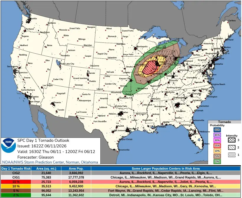
The later severe weather risk depends on redevelopment along the southern and western flank of the ongoing convection from northern Illinois into northeast Missouri. If semi-discrete supercells are maintained, several tornadoes and multiple strong to intense tornadoes rated EF2/EF3+ are possible, with isolated large to very large hail from sustained supercells.
Additionally, numerous to potentially widespread severe and damaging winds can be expected from northern and central Illinois into southern Lower Michigan and northern Indiana, with some gusts again forecast to exceed 120 km/h (75 mph). Thunderstorms are also forecast along the trailing cold front from eastern Kansas and southern Missouri into parts of the Southern Plains this afternoon and evening.
Tornado Watch 311 remains in effect until 20:00 UTC for southern and eastern Iowa, northwest Illinois, and far northern Missouri. SPC said a few tornadoes and a couple of intense tornadoes are possible, widespread damaging winds are likely with isolated significant gusts to 130 km/h (80 mph), and scattered large hail with isolated very large hail to 5.1 cm (2 inches) in diameter.
Hail and wind reports had already been submitted to SPC from Iowa and Missouri. Hail reports included 4.4 cm (1.75 inches) hail near Attica, Osceola, Knoxville, Harvey, and Bussey in Iowa, while wind reports included tree damage, a tree blocking IA-141 north-northeast of Grimes, a 108 km/h (67 mph) gust west of Chariton, a 116 km/h (72 mph) gust south of Ames, and a 98 km/h (61 mph) gust south-southwest of Knoxville.
The National Weather Service (NWS) Chicago/Romeoville office issued a Level 4 of 5 damaging wind risk for north-central Illinois, northeast Illinois, and northwest Indiana, with wind gusts up to 130 km/h (80 mph). The outlook included a Level 3 of 5 tornado risk, a Level 2 of 5 isolated large hail risk with hail up to 5.1 cm (2 inches) in diameter, an elevated flooding risk, and a second wave of more substantial storms expected from 16:00 to 22:00 CDT (21:00–03:00 UTC).
The Chicago forecast office said storms this afternoon and evening will be capable of producing tornadoes and destructive winds, some possibly significant. Flash flooding may occur where thunderstorms repeatedly move over the same area.
Southeast Michigan remains in the late evening and overnight severe weather corridor. NWS Detroit/Pontiac said a Slight to Enhanced Risk is in place mainly between 20:00 and 03:00 EDT (00:00–07:00 UTC on June 12), with damaging winds, large hail, and spin-up tornadoes possible.
The office said a storm line is expected near the terminal corridor between 02:00 and 06:00 UTC, with uncertainty over how much strength it maintains into southeast Michigan.
The line could become a high-impact severe weather event if it maintains full strength, with bowing segments capable of winds over 110 km/h (70+ mph) and embedded tornadic circulations. The office also noted low predictability on where or whether the line weakens as it crosses southeast Michigan overnight.
A separate severe weather area is developing across parts of the Mid-Atlantic and central Appalachians. SPC’s Mesoscale Discussion 1087, issued at 16:27 UTC, covers western Pennsylvania, eastern Ohio, western Maryland, north-central Virginia, and much of West Virginia, with a 60% probability of watch issuance and a main risk of severe wind gusts, along with some hail. Most probable peak wind gusts are 90–115 km/h (55–70 mph), and hail size is up to 3 cm (1.25 inches).
References:
1 Day 1 Convective Outlook – NWS/SPC – June 11, 2026
I'm a dedicated researcher, journalist, and editor at The Watchers. With over 20 years of experience in the media industry, I specialize in hard science news, focusing on extreme weather, seismic and volcanic activity, space weather, and astronomy, including near-Earth objects and planetary defense strategies. You can reach me at teo /at/ watchers.news.
Commenting rules and guidelines
We value the thoughts and opinions of our readers and welcome healthy discussions on our website. In order to maintain a respectful and positive community, we ask that all commenters follow these rules.