
Typhoon Mekkhala tracks northward east of Batanes, enhancing the southwest monsoon over the Philippines
Typhoon Mekkhala weakened and continued moving slowly northward east of Batanes on June 23, 2026, after reaching Super Typhoon strength on June 22. Its circulation enhanced southwest monsoon conditions across the Philippines, bringing the threat of localized flooding, landslides, hazardous marine conditions, and strong winds over a broad area of the country.
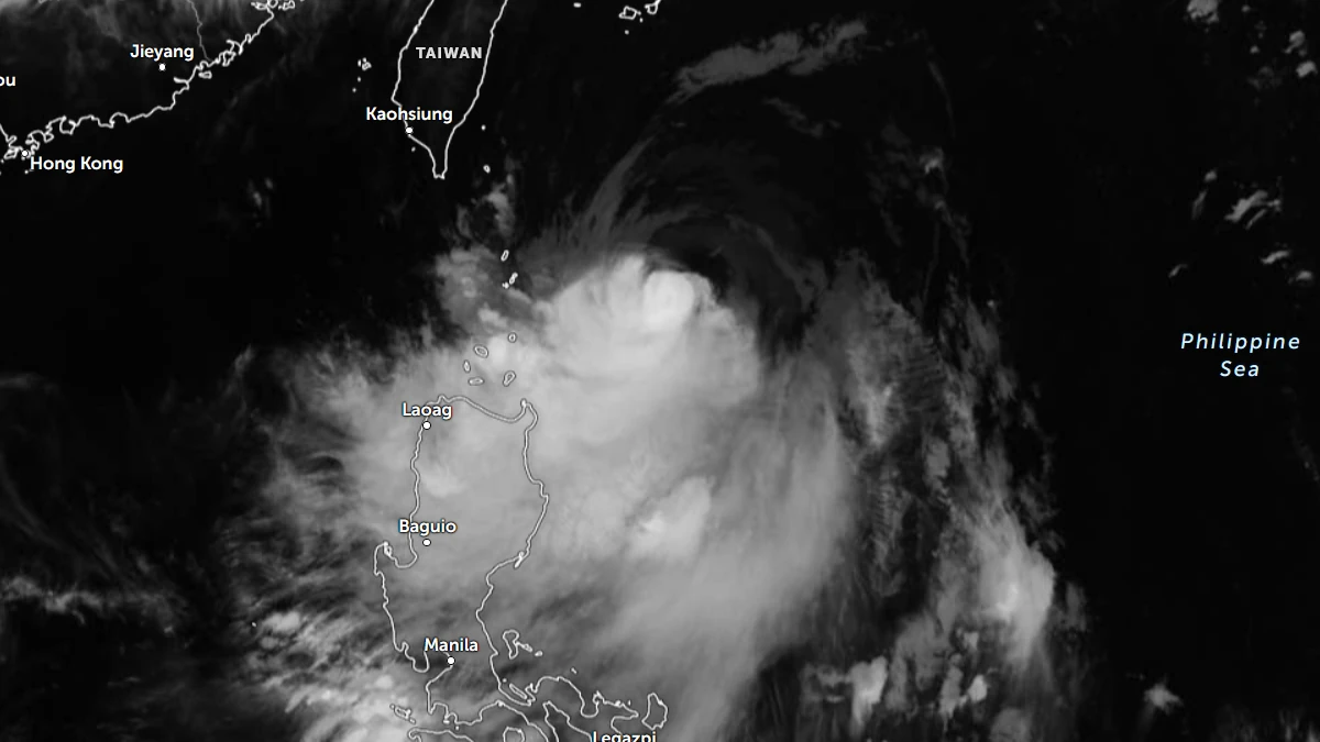
Satellite image of Typhoon Mekkhala at 19:10 UTC on June 23, 2026. Credit: JMA/Himawari-9, Zoom Earth, The Watchers
Typhoon Mekkhala, locally named Typhoon Mekkhala, continued moving slowly northward east of Batanes on June 23, as its circulation enhanced southwest monsoon conditions across the Philippines, bringing the threat of localized flooding, landslides, hazardous marine conditions, and strong winds over a broad area of the country.
The storm was approximately 320 km (199 miles) east of Calayan, Cagayan, with maximum sustained winds of 165 km/h (103 mph), gusts up to 205 km/h (127 mph), and a minimum central pressure of 945 hPa. Strong to typhoon-force winds extended up to 360 km (224 miles) from the center, at 23:00 LT (15:00 UTC) on June 23.
Earlier, the system had reached Super Typhoon strength at 22:00 LT on June 22, when it touched 10-minute sustained winds of 185 km (115 mph) with gusts of 230 km/h (142 mph). The estimated minimum central pressure at the time was 940 hPa.
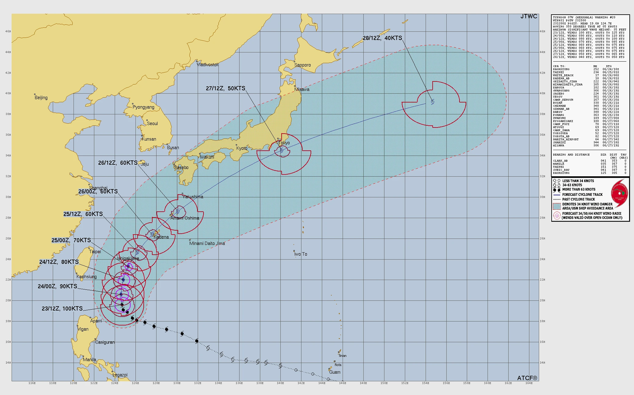
The cyclone was moving slowly northward and had begun a gradual weakening trend. PAGASA noted that Mekkhala had slightly weakened while decelerating east of extreme northern Luzon. The typhoon is forecast to continue northward through June 24 before turning north-northeastward and then northeastward toward the Ryukyu Islands and the waters south of mainland Japan.
The system was forecast to remain a typhoon throughout its stay inside the PAR before weakening to a severe tropical storm after moving farther northeast.
According to PAGASA’s forecast track, the center was expected to pass about 300 km (186 miles) east of Itbayat, Batanes by 08:00 LT on June 24 and 350 km (217 miles) east-northeast of Itbayat by 20:00 LT the same day.
By June 25, the typhoon was forecast to move 470 km (292 miles) northeast of Itbayat in the morning and 610 km (379 miles) northeast of the island by evening. PAGASA projected that Mekkhala would move outside the PAR by the evening of June 25 or the morning of June 26, reaching approximately 1 100 km (684 miles) northeast of extreme northern Luzon by the evening of June 26.
PAGASA maintained Tropical Cyclone Wind Signal No. 1 over Batanes and the northeastern portion of Cagayan, including Gonzaga, Santa Ana, and the Babuyan Islands. Areas under Signal No. 1 faced expected wind speeds of 39 to 61 km/h (24 to 38 mph), with minimal to minor impacts on life and property possible. PAGASA noted that the likelihood of raising Signal No. 2 had decreased as the typhoon began moving northward away from northern Luzon.
Although the center was forecast to remain offshore, the typhoon continued to pose rainfall hazards to the northern Philippines.
50 to 100 mm (2 to 3.9 inches) of rainfall is forecast over Batanes and Cagayan through June 24, with an additional 50 to 100 mm over Batanes through June 25.
Localized flooding was possible in urbanized and low-lying areas, while landslides were possible in areas highly susceptible to slope failures. PAGASA also warned that rainfall totals could be higher in mountainous and elevated terrain and that impacts could be aggravated by antecedent rainfall.
The cyclone also enhanced southwest monsoon conditions over western sections of the Philippines. PAGASA forecast 50 to 100 mm (2 to 3.9 inches) of rainfall over Palawan, Occidental Mindoro, and Antique through June 24, shifting to Palawan, Occidental Mindoro, and Bataan through June 25, and then to Occidental Mindoro, Zambales, and Bataan through June 26. These areas faced the potential for localized flooding and landslides, particularly in urbanized, low-lying, riverine, and landslide-prone locations.
In addition to rainfall hazards, PAGASA warned that the southwest monsoon and the outer circulation of Mekkhala would bring strong to gale-force gusts across much of Luzon and Visayas.
On June 23, these gusts were forecast over most of Luzon, most of Visayas, Zamboanga Peninsula, Northern Mindanao, Dinagat Islands, Davao Occidental, and Davao Oriental. Similar conditions were expected on June 24, while strong gusts were forecast to persist over most of Luzon, Panay Island, Negros Occidental, and Northern Samar on June 25.
Marine conditions remained hazardous across northern Philippine waters. PAGASA’s Gale Warning covered the northern and eastern seaboards of Northern Luzon.
Very rough seas reaching up to 4.5 m (14.8 feet) were forecast along the eastern seaboards of Batanes and the Babuyan Islands and along the northeastern coast of mainland Cagayan. Rough seas of up to 3.5 m (11.5 feet) were expected elsewhere around Batanes and the Babuyan Islands, while seas up to 3 m (9.8 feet) were forecast along the remaining coastlines of Cagayan and Isabela. PAGASA advised all mariners to remain in port or seek safe harbor until conditions improved.
Moderate to rough seas were also forecast along a broad stretch of the Philippine coastline. Wave heights of up to 2.5 m (8.2 feet) were expected along the coasts of Aurora, northern Ilocos Norte, the Polillo Islands, Catanduanes, Camarines Norte, Camarines Sur, and Davao Oriental.
Seas of up to 2 m (6.6 feet) were forecast along northern Quezon, the Kalayaan Islands, Northern Samar, Albay, Sorsogon, Eastern Samar, Dinagat Islands, Surigao del Sur, and southwestern Palawan. PAGASA advised operators of motorbancas and similarly sized vessels to exercise caution and avoid navigation when possible.
The Joint Typhoon Warning Center (JTWC) forecast the typhoon to continue moving northward for approximately 36 hours before turning northeastward toward Okinawa. The closest approach to Kadena Air Base on Okinawa was forecast around June 26.
Beyond the Ryukyu Islands, the cyclone was projected to accelerate northeastward and pass south of Tokyo before undergoing extratropical transition near the end of the forecast period. JTWC expected weakening to continue through approximately 48 hours as high vertical wind shear persisted and the storm moved over progressively cooler waters.
Mekkhala developed from a tropical disturbance over the western North Pacific before strengthening into Tropical Depression 07W and later Tropical Storm Mekkhala. After entering the PAR on June 20, PAGASA assigned the local name Mekkhala. The cyclone intensified over the Philippine Sea before beginning a gradual weakening trend east of northern Luzon.
References:
1 Tropical Cyclone Bulletin No. 13 – PAGASA – June 23, 2026
2 Prognostic Reasoning for Typhoon 07W (Mekkhala), Warning No. 20. – JTWC – June 23, 2026

I am an Assistant Editor and Severe Weather & Science Journalist at The Watchers, specializing in real-time severe weather coverage, geophysical event reporting, and research-driven scientific analysis. You can reach me at rishav(at)watchers(.)news.
Commenting rules and guidelines
We value the thoughts and opinions of our readers and welcome healthy discussions on our website. In order to maintain a respectful and positive community, we ask that all commenters follow these rules.